- Mirny, Arkhangelsk Oblast
-
For other uses, see Mirny (disambiguation).
Mirny (English)
Мирный (Russian)- Town[1] -
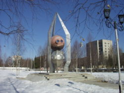
Monument in Mirny, featuring a genuine spacecraft capsule, commemorating the Kosmos-2000 spacecraft launch from Plesetsk Cosmodrome on February 2, 1989
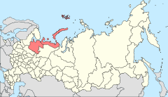
Location of Arkhangelsk Oblast in RussiaCoordinates: 62°46′N 40°20′E / 62.767°N 40.333°ECoordinates: 62°46′N 40°20′E / 62.767°N 40.333°E Administrative status Country Russia Federal subject Arkhangelsk Oblast Administratively subordinated to Mirny Town of Oblast Significance[2] Administrative center of Mirny Town of Oblast Significance[1] Municipal status Urban okrug Mirny Urban Okrug[3] Statistics Population (2010 Census,
preliminary)30,259 inhabitants[4] Population (2002 Census) 30,502 inhabitants[5] Time zone MSD (UTC+04:00)[6] Founded November 23, 1960[7] Town status since February 2, 1966[7] Official website Mirny (Russian: Ми́рный, lit. peaceful) is a closed town in the west of Arkhangelsk Oblast, Russia, serving the Plesetsk Cosmodrome. Administratively, it is incorporated as a town of oblast significance, while municipally, it is incorporated as Mirny Urban Okrug of Arkhangelsk Oblast.[3] Population: 30,259 (2010 Census preliminary results);[4] 30,502 (2002 Census).[5]
Mirny's closed town status means that there is no access to it without a special permit.
The town is located 9 kilometers (5.6 mi) from the urban-type settlement of Plesetsk and is connected to it by a road and a railway. Gorodskaya railway station is located within the town being a terminus to cosmodrome's vast railway system. Plestsy Airport is also located nearby.
Contents
History
In 1957, an area for the settlement for ballistic missile launch site workers was designated. In 1958, the population of the area, about 4,000, was resettled; the same year the construction started. On November 23, 1960 the settlement of Mirny was established. In 1966, with the development of the cosmodrome, it was designated a closed town. Mirny was never mentioned in the media before 1983.[7]
Location and geography
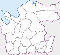
The area administered by the town borders with Kholmogorsky District in the north, Vinogradovsky District in the east, and Plesetsky District in the south and in the west. The area is elongated from the east to the west and is approximately 50 kilometers (31 mi) long and 20 kilometers (12 mi) wide. The town proper is located in the extreme southwestern end of the area. The Yemtsa River flows in the north of the area, whereas the Mekhrenga River crosses it south to north in the eastern part. The whole area belongs to the Northern Dvina River basin. Except for the military installations, it is covered by coniferous forest (taiga).
References
- ^ a b Государственный комитет Российской Федерации по статистике. Комитет Российской Федерации по стандартизации, метрологии и сертификации. №ОК 019-95 1 января 1997 г «Общероссийский классификатор объектов административно-территориального деления. Код 11 525 007», в ред. изменения №168/2011 от 1 октября 2011 г. (State Statistics Committee of the Russian Federation. Committee of the Russian Federation on Standardization, Metrology, and Certification. #OK 019-95 January 1, 1997 Russian Classification of Objects of Administrative Division . Code 11 525 007, as amended by the Amendment #168/2010 of October 1, 2011. ).
- ^ Law #65-5-OZ
- ^ a b Архангельское областное Собрание депутатов. Областной закон №258-внеоч.-ОЗ от 23 сентября 2004 г. «О статусе и границах территорий муниципальных образований в Архангельской области (текст в ред. от 15 февраля 2010 г.)», в ред. Областного закона №309-23-ОЗ от 7 июля 2011 г «О внесении изменений и дополнений в отдельные Областные законы в сфере организации и осуществления местного самоуправления». Вступил в силу со дня официального опубликования. Опубликован: "Волна", №38, 8 октября 2004 г. (Arkhangelsk Oblast Council of Deputies. Oblast Law #258-vneoch.-OZ of September 23, 2004 On the Status and Borders of the Territories of the Municipal Formations in Arkhangelsk Oblast (text of rev. of February 15, 2010), as amended by the Oblast Law #309-23-OZ of July 7, 2011 On Amending and Supplementing Several Oblast Laws on the Subject of Organization and Implementation of the Local Self-Government. Effective as of the day of the official publication).
- ^ a b Федеральная служба государственной статистики (Federal State Statistics Service) (2011). "Предварительные итоги Всероссийской переписи населения 2010 года (Preliminary results of the 2010 All-Russian Population Census)" (in Russian). Всероссийская перепись населения 2010 года (All-Russia Population Census of 2010). Federal State Statistics Service. http://www.perepis-2010.ru/results_of_the_census/results-inform.php. Retrieved 2011-04-25.
- ^ a b Федеральная служба государственной статистики (Federal State Statistics Service) (2004-05-21). "Численность населения России, субъектов Российской Федерации в составе федеральных округов, районов, городских поселений, сельских населённых пунктов – районных центров и сельских населённых пунктов с населением 3 тысячи и более человек (Population of Russia, its federal districts, federal subjects, districts, urban localities, rural localities—administrative centers, and rural localities with population of over 3,000)" (in Russian). Всероссийская перепись населения 2002 года (All-Russia Population Census of 2002). Federal State Statistics Service. http://www.perepis2002.ru/ct/doc/1_TOM_01_04.xls. Retrieved 2010-03-23.
- ^ Правительство Российской Федерации. Постановление №725 от 31 августа 2011 г. «О составе территорий, образующих каждую часовую зону, и порядке исчисления времени в часовых зонах, а также о признании утратившими силу отдельных Постановлений Правительства Российской Федерации». Вступил в силу по истечении 7 дней после дня официального опубликования. Опубликован: "Российская Газета", №197, 6 сентября 2011 г. (Government of the Russian Federation. Resolution #725 of August 31, 2011 On the Composition of the Territories Included into Each Time Zone and on the Procedures of Timekeeping in the Time Zones, as Well as on Abrogation of Several Resolutions of the Government of the Russian Federation. Effective as of after 7 days following the day of the official publication).
- ^ a b c "Information on Mirny on the official website" (in English). Mirny Urban Settlement. http://www.mirniy.ru/official/cityinfo/14-english.html. Retrieved 16 August 2011.
External links
- "Муниципальное образование Мирный" (in Russian). Mirny Urban Settlement. http://mirniy.ru/. Retrieved 15 August 2011.
- "Information on Mirny on the official website" (in English). Mirny Urban Settlement. http://www.mirniy.ru/official/cityinfo/14-english.html. Retrieved 15 August 2011.
Administrative divisions of Arkhangelsk Oblast Administrative center: Arkhangelsk Cities and towns Arkhangelsk · Kargopol · Koryazhma · Kotlas · Mezen · Mirny · Naryan-Mar · Novodvinsk · Nyandoma · Onega · Severodvinsk · Shenkursk · Solvychegodsk · Velsk

Districts (raions) Kargopolsky · Kholmogorsky · Konoshsky · Kotlassky · Krasnoborsky · Lensky · Leshukonsky · Mezensky · Novaya Zemlya · Nyandomsky · Onezhsky · Pinezhsky · Plesetsky · Primorsky · Shenkursky · Solovetsky · Ustyansky · Velsky · Verkhnetoyemsky · Vilegodsky · VinogradovskyBolshoy Kamen · Fokino · Gadzhiyevo · Krasnoznamensk · Lesnoy · Mezhgorye · Mirny · Norilsk · Novouralsk · Omutninsk · Ostrovnoy · Ozyorsk · Polyarny · Raduzhny · Sarov · Severomorsk · Seversk · Shikhany · Snezhinsk · Snezhnogorsk · Tryokhgorny · Uglegorsk · Vilyuchinsk · Zaozyorsk · Zarechny · Zelenogorsk · Zheleznogorsk · Znamensk
 Categories:
- Closed cities
- Cities and towns in Arkhangelsk Oblast
- Cities and towns built in the Soviet Union
- Populated places established in 1957
- Naukograds
Wikimedia Foundation. 2010.


