- Onezhsky District
-
Onezhsky District (English)
Онежский район (Russian)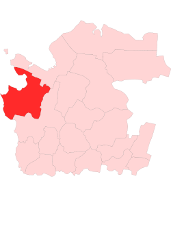
Location of Onezhsky District within Arkhangelsk OblastCoordinates: 63°43′N 37°27′E / 63.717°N 37.45°ECoordinates: 63°43′N 37°27′E / 63.717°N 37.45°E 

Coat of Arms of Onezhsky District Flag of Onezhsky District Administrative status Country Russia Federal subject Arkhangelsk Oblast Administrative center town of Onega[1] # of cities/towns 0[1] # of urban-type settlements 1[1] # of selsoviets 13[1] Municipal status (as of July 2011) Municipally incorporated as Onezhsky Municipal District[2] - # of urban settlements 2[2] - # of rural settlements 6[2] Statistics Area 23,740 km2 (9,170 sq mi)[3] Population (2010 Census,
preliminary)14,016 inhabitants[4] Population (2002 Census) 16,791 inhabitants[5] - Urban population 18.8% - Rural population 81.2% Density 1 /km2 (2.6 /sq mi)[6] Time zone MSD (UTC+04:00)[7] Established July 15, 1929 Official website Onezhsky District (Russian: Онежский райо́н) is an administrative district (raion), one of the twenty-one in Arkhangelsk Oblast, Russia.[8] Municipally, it is incorporated as Onezhsky Municipal District.[2] It is located in the northwest of the oblast and borders with Primorsky District in the northeast, Plesetsky District in the southeast, Pudozhsky, Medvezhyegorsky, and Segezhsky Districts of the Republic of Karelia in the southwest, and Belomorsky District of the Republic of Karelia in the west. From the north, the district borders the White Sea. Its administrative center is the town of Onega.[1] District's population: 14,016 (2010 Census preliminary results);[4] 16,791 (2002 Census);[5] 22,269 (1989 Census).[9]
The town of oblast significance of Onega is administratively separate from the district, but municipally is a part of it (incorporated as Onega Urban Settlement).
Contents
History
The area was originally populated by the Finno-Ugric peoples and then colonized by the Novgorod Republic. It was located at the trading route connecting central and northern Russia, from Moscow to the White Sea along the Onega River. After the fall of Novgorod, the area became a part of the Grand Duchy of Moscow. The descendants of the Novgorod population are the Pomors who inhabit the White Sea coast and traditionally are engaged in fishery. Many villages in the district along the coast, such as Unezhma (now abandoned),[10] have historical significance as old Pomor villages. The western coast of the Onega Bay is known as Pomor Coast (Pomorsky Bereg).
In the course of the administrative reform carried out in 1708 by Peter the Great, the area was included into Archangelgorod Governorate. In 1780, the governorate was abolished and transformed into Vologda Viceroyalty, and Onega was granted town rights. In 1796, the area was transferred to Arkhangelsk Governorate. The current territory of the district was included into Onezhsky Uyezd. In 1929, several governorates were merged into Northern Krai.
On July 15, 1929, the uyezds were abolished, the governorates merged into Northern Krai, and Onezhsky District was established among others. It became a part of Arkhangelsk Okrug of Northern Krai.[11]
In the following years, the first-level administrative division of Russia kept changing. In 1930, the okrug was abolished, and the district became subordinate to the central administration of Northern Krai. In 1936, the krai itself was transformed into Northern Oblast. In 1937, Northern Oblast was split into Arkhangelsk Oblast and Vologda Oblast. Onezhsky District remained in Arkhangelsk Oblast ever since.
Between July 15, 1929 and July 31, 1931, Chekuyevsky District with the center in the selo of Chekuyevo existed and was part of Northern Krai. In 1931, the district was abolished, and its area divided between Plesetsky and Onezhsky Districts.[12]
On December 17, 1940, Belomorsky District was established on the Onega Peninsula, on the areas which previously were parts of Primorsky and Onezhsky Districts. The administrative center of the district was established in the selo of Pertominsk. On September 30, 1958, Belomorsky District was abolished, with its area shared between Primorsky and Onezhsky Districts.[12]
Location and geography
The district occupies the lower course of the Onega River and the White Sea coast around the Onega Bay, including the western part of the Onega Peninsula (which it shares with Primorsky District. The area of the district drains to the Onega and short rivers of the Onega Bay basin. The main tributaries of the Onega within the district limits are the Kodina River and the Kozha River. The exception is the southwestern part of the district which drains into the Ileksa River, a tributary of Lake Vodlozero, in the Baltic Sea basin. The divide between Arctic and Atlantic Oceans thus runs through the district. There are many lakes throughout the district; the biggest one being Lake Kozhozero, the source of the Kozha, a left tributary of the Onega. The islands in the Onega Bay are also administered by Onezhsky District. The biggest island of the Onega Bay is Kiy Island.
Vodlozersky National Park was established in 1991 in the river valley of the Ileksa to protect the taiga coniferous forests. Since 2001, the National Park has the status of the UNESCO Biosphere Reserve, the first one in Russia. The park is shared between Onezhsky District of Arkhangelsk Oblast and Pudozhsky District of the Republic of Karelia.[13] It was planned that one more national park, Onezhskoye Pomorye National Park, would be opened at the coast of the Onega Peninsula to protect pristine forests; however, the creation of the park was delayed and is not currently on the agenda.[14]
Divisions
Administrative divisions
Administratively, the district is divided into thirteen selsoviets and one urban-type settlement (Maloshuyka).[1] Two other localities which previously had a urban-type settlement status were downgraded to rural localities in 2002. These are Kodino and Mudyuga.[1] The following selsoviets have been established (the administrative centers are given in parentheses):
- Chekuyevsky (Antsiferovsky Bor);
- Khachelsky (Khachela);
- Kodinsky (Kodino);
- Kokorinsky (Porog);
- Mudyuzhsky (Mudyuga);
- Nimengsky (Nimenga);
- Posadny (Posad);
- Priluksky (Priluki);
- Purnemsky (Purnema);
- Sulozersky (Zolotukha);
- Tamitsky (Tamitsa);
- Ust-Kozhsky (Ust-Kozha);
- Vekhneozersky (Vekhneozersky).
Municipal divisions
Municipally, the district is divided into two urban settlements and six rural settlements (the administrative centers are given in parentheses):[2]
- Maloshuyskoue Urban Settlement (Maloshuyka);
- Onezhskoye Urban Settlement (Onega);
- Chekuyevskoye Rural Settlement (Antsiferovsky Bor);
- Kodinskoye Rural Settlement (Kodino);
- Nimengskoye Rural Settlement (Nimenga);
- Pokrovskoye Rural Settlement (Pokrovskoye);
- Porozhskoye Rural Settlement (Porog);
- Zolotukhskoye Rural Settlement (Zolotukha).
Economy
Industry
The economy of the district is based on timber industry. There is also production of construction materials.[15]
Agriculture
Fishery was a traditional occupation of Pomors on the White Sea coast. There are still two fishing collective farms. Inland, there is production of milk and meat as well as potatoes and vegetables.[15]
Transport
The only railway line in the district branches off in Obozerskaya railway station from the railroad between Moscow and Arkhangelsk and runs west to Onega and Belomorsk where it joins the railroad between Petrozavodsk and Murmansk. It was built during the World War II to secure the transport of goods from the harbor of Murmansk to central Russia.
Onega is connected to Severodvinsk by a road. There are no all-seasonal roads on the left bank of the Onega River within the district.
The Onega is navigable downstream from the selo of Porog; there is regular passenger navigation. There is also limited passenger service on the Onega Bay.
Onega is served by the Onega Airport which has weekly passenger flights to Arkhangelsk and to the selo of Purnema on the Onega Peninsula.
Culture and recreation
Onezhsky District has a very high concentration of historical, archaeological, and architectural monuments. The district contains thirty-two objects classified as cultural and historical heritage by Russian Federal law, and additionally eighteen objects classified as cultural and historical heritage of local importance.[16] Most of these are wooden churches and chapels located in the area.
The monuments classified as historical and architectural heritage are the following:
- The Ascention Church in the village of Kusheretskaya (17th century) — has been moved to the Malye Korely open air museum;
- The ensemble of Makaryinsky Pogost (St. Makarius Church, the Church of the Erection of the Cross, and the bell-tower, 17th and 18th century) in the village of Makaryinskaya — burnt down in 1985 and does not exist any more;
- The wooden St. Nicholas church in the village of Nizhmozero — burnt down in 1970s;
- The wooden St. Iliya Church in the village of Vazentsy — destroyed in 1970s;
- The ensemble of Verkhnemudyugsky Pogost (the Church of the Entrance to Jerusalem, the Church of the Tikhvin icon of the Virgin, and the bell-tower, 18th century) in the village of Verkhovye — burnt down in 1997 and does not exist any more;
- The ensemble of the former monastery on Kiy Island;
- The ensemble of the Maloshuyka Pogost, consisting of wooden St. Nicholas Church (1638), the Presentation of Jesus at the Temple (1873), and the bell-tower (1825), located in the village of Abramovskaya;
- The chapel of the Erection of the Cross (18th century) in the village of Matveevka;
- The chapel of St. George in the village of Nermushi;
- The ensemble of the Piyala Pogost, consisting of the Ascencion Church (1654) and the bell-tower (1700);
- The ensemble of the Purnema Pogost, consisting of the St. Nicholas Church (1618) and the Nativity Church (1860);
- The ensemble of the Turchasovsky Pogost, consisting of the Transfiguration Church (1786) and the bell-tower (1908).
The most notable wooden churches are triple church ensembles, which consist of two churches (a bigger, not heated, church used in the summer, a smaller, heated church used in the winter, and a bell-tower). Not more than a dozen of these triple wooden ensembles survived intact, and two of them (the Piyala Pogost and the ensemble in the selo of Vorzogory) are located in Onezhsky District, in the village of Abramovskaya. Two more, Makaryinsky Pogost and Verkhnemudyugsky Pogost, burned down in 1985 and 1997, respectively.
The Kozheozersky Monastery, founded in 1560, has a great historical value. Nikon, the future patriarch of Moscow and reformer of Russian Orthodox Church, was an abbot of the monastery from 1643 to 1646. The monastery is located on a peninsula (formerly an island) on Lake Kozhozero and can only be accessed by hiking up the Kozha River for several days.
The only state museum in the district is the Onega Historical Museum.[17]
References
Notes
- ^ a b c d e Государственный комитет Российской Федерации по статистике. Комитет Российской Федерации по стандартизации, метрологии и сертификации. №ОК 019-95 1 января 1997 г «Общероссийский классификатор объектов административно-территориального деления. Код 11 246», в ред. изменения №168/2011 от 1 октября 2011 г. (State Statistics Committee of the Russian Federation. Committee of the Russian Federation on Standardization, Metrology, and Certification. #OK 019-95 January 1, 1997 Russian Classification of Objects of Administrative Division . Code 11 246, as amended by the Amendment #168/2010 of October 1, 2011. ).
- ^ a b c d Law #258-vneoch.-OZ
- ^ "Онежский район" (in Russian). Двина-Информ. http://www.dvinainform.ru/clients/21/. Retrieved 6 August 2011.
- ^ a b Федеральная служба государственной статистики (Federal State Statistics Service) (2011). "Предварительные итоги Всероссийской переписи населения 2010 года (Preliminary results of the 2010 All-Russian Population Census)" (in Russian). Всероссийская перепись населения 2010 года (All-Russia Population Census of 2010). Federal State Statistics Service. http://www.perepis-2010.ru/results_of_the_census/results-inform.php. Retrieved 2011-04-25.
- ^ a b Федеральная служба государственной статистики (Federal State Statistics Service) (2004-05-21). "Численность населения России, субъектов Российской Федерации в составе федеральных округов, районов, городских поселений, сельских населённых пунктов – районных центров и сельских населённых пунктов с населением 3 тысячи и более человек (Population of Russia, its federal districts, federal subjects, districts, urban localities, rural localities—administrative centers, and rural localities with population of over 3,000)" (in Russian). Всероссийская перепись населения 2002 года (All-Russia Population Census of 2002). Federal State Statistics Service. http://www.perepis2002.ru/ct/doc/1_TOM_01_04.xls. Retrieved 2010-03-23.
- ^ The value of density was calculated automatically by dividing the 2010 Census population by the area specified in the infobox. Please note that this value may not be accurate as the area specified in the infobox does not necessarily correspond to the area of the entity proper or is reported for the same year as the population.
- ^ Правительство Российской Федерации. Постановление №725 от 31 августа 2011 г. «О составе территорий, образующих каждую часовую зону, и порядке исчисления времени в часовых зонах, а также о признании утратившими силу отдельных Постановлений Правительства Российской Федерации». Вступил в силу по истечении 7 дней после дня официального опубликования. Опубликован: "Российская Газета", №197, 6 сентября 2011 г. (Government of the Russian Federation. Resolution #725 of August 31, 2011 On the Composition of the Territories Included into Each Time Zone and on the Procedures of Timekeeping in the Time Zones, as Well as on Abrogation of Several Resolutions of the Government of the Russian Federation. Effective as of after 7 days following the day of the official publication).
- ^ Архангельское областное Собрание депутатов. Областной закон №65-5-ОЗ от 23 сентября 2009 г. «Об административно-территориальном устройстве Архангельской области», в ред. Областного закона №150-12-ОЗ от 4 мая 2010 г «О внесении изменений и дополнений в отдельные областные законы». Вступил в силу через десять дней со дня официального опубликования. Опубликован: "Волна", №43, 6 октября 2009 г. (Arkhangelsk Oblast Council of Deputies. Oblast Law #65-5-OZ of September 23, 2009 On the Administrative and Territorial Structure of Arkhangelsk Oblast, as amended by the Oblast Law #150-12-OZ of May 4, 2010 On Amending and Supplementing Certain Oblast Laws. Effective as of the day ten days after the official publication).
- ^ "Всесоюзная перепись населения 1989 г. Численность наличного населения союзных и автономных республик, автономных областей и округов, краёв, областей, районов, городских поселений и сёл-райцентров. (All Union Population Census of 1989. Present population of union and autonomous republics, autonomous oblasts and okrugs, krais, oblasts, districts, urban settlements, and villages serving as district administrative centers.)" (in Russian). Всесоюзная перепись населения 1989 года (All-Union Population Census of 1989). Demoscope Weekly (website of the Institute of Demographics of the State University—Higher School of Economics. 1989. http://demoscope.ru/weekly/ssp/rus89_reg.php. Retrieved 2010-03-23.
- ^ Федосеева, Елена. "Унежма" (in Russian). Страна Наоборот. http://www.strana-naoborot.com/Unezhma/unezhma.htm. Retrieved 16 August 2011.
- ^ "Постановление Президиума ВЦИК от 15 июля 1929 года о составе округов и районов Северного Края и их центрах" (in Russian). consultant.ru. http://base.consultant.ru/cons/cgi/online.cgi?req=doc;base=ESU;n=15910. Retrieved 12 June 2011.
- ^ a b "Административно-территориальное деление Архангельской губернии в XVIII-XX вв. (Справка)" (in Russian). Архивы России. 2000. http://guides.rusarchives.ru/browse/guidebook.html?bid=79&sid=185080. Retrieved 12 August 2011.
- ^ "Водлозерский Биосферный резерват" (in Russian). ООПТ России. http://oopt.info/index.php?oopt=657. Retrieved 17 August 2011.
- ^ Логинова, Марья (2010). "«Онежское Поморье» - ещё можно успеть". Правда Севера. http://www.pravdasevera.ru/print.html?article=1051779954.
- ^ a b "Общие сведения" (in Russian). МО "Онежский район". http://www.onega.ru/economy/date.htm. Retrieved 16 August 2011.
- ^ "Памятники истории и культуры народов Российской Федерации" (in Russian). Russian Ministry of Culture. http://kulturnoe-nasledie.ru/. Retrieved 15 August 2011.
- ^ "Онежский историко-мемориальный музей" (in Russian). Музеи России. http://www.museum.ru/M943. Retrieved 15 August 2011.
Sources
- Архангельское областное Собрание депутатов. Областной закон №65-5-ОЗ от 23 сентября 2009 г. «Об административно-территориальном устройстве Архангельской области», в ред. Областного закона №150-12-ОЗ от 4 мая 2010 г «О внесении изменений и дополнений в отдельные областные законы». Вступил в силу через десять дней со дня официального опубликования. Опубликован: "Волна", №43, 6 октября 2009 г. (Arkhangelsk Oblast Council of Deputies. Oblast Law #65-5-OZ of September 23, 2009 On the Administrative and Territorial Structure of Arkhangelsk Oblast, as amended by the Oblast Law #150-12-OZ of May 4, 2010 On Amending and Supplementing Certain Oblast Laws. Effective as of the day ten days after the official publication).
- Архангельское областное Собрание депутатов. Областной закон №258-внеоч.-ОЗ от 23 сентября 2004 г. «О статусе и границах территорий муниципальных образований в Архангельской области (текст в ред. от 15 февраля 2010 г.)», в ред. Областного закона №309-23-ОЗ от 7 июля 2011 г «О внесении изменений и дополнений в отдельные Областные законы в сфере организации и осуществления местного самоуправления». Вступил в силу со дня официального опубликования. Опубликован: "Волна", №38, 8 октября 2004 г. (Arkhangelsk Oblast Council of Deputies. Oblast Law #258-vneoch.-OZ of September 23, 2004 On the Status and Borders of the Territories of the Municipal Formations in Arkhangelsk Oblast (text of rev. of February 15, 2010), as amended by the Oblast Law #309-23-OZ of July 7, 2011 On Amending and Supplementing Several Oblast Laws on the Subject of Organization and Implementation of the Local Self-Government. Effective as of the day of the official publication).
External links
- "Официальный сайт муниципального образования "Онежский муниципальный район" / Official website of the district" (in Russian). http://www.onega.ru/. Retrieved August 15, 2011.
Administrative divisions of Arkhangelsk Oblast Administrative center: ArkhangelskCities and towns Arkhangelsk · Kargopol · Koryazhma · Kotlas · Mezen · Mirny · Naryan-Mar · Novodvinsk · Nyandoma · Onega · Severodvinsk · Shenkursk · Solvychegodsk · Velsk

Districts (raions) Kargopolsky · Kholmogorsky · Konoshsky · Kotlassky · Krasnoborsky · Lensky · Leshukonsky · Mezensky · Novaya Zemlya · Nyandomsky · Onezhsky · Pinezhsky · Plesetsky · Primorsky · Shenkursky · Solovetsky · Ustyansky · Velsky · Verkhnetoyemsky · Vilegodsky · VinogradovskyCategories:- Districts of Arkhangelsk Oblast


Wikimedia Foundation. 2010.