- Mezensky District
-
Mezensky District (English)
Мезенский район (Russian)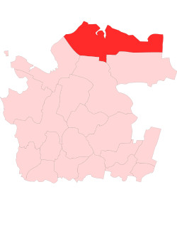
Location of Mezensky District within Arkhangelsk OblastCoordinates: 64°51′N 44°14′E / 64.85°N 44.233°ECoordinates: 64°51′N 44°14′E / 64.85°N 44.233°E 
Coat of Arms of Mezensky District Administrative status Country Russia Federal subject Arkhangelsk Oblast Administrative center town of Mezen[1] # of cities/towns 1[1] # of urban-type settlements 1[1] # of selsoviets 13[1] Municipal status (as of July 2011) Municipally incorporated as Mezensky Municipal District[2] - # of urban settlements 0[2] - # of rural settlements 6[2] Statistics Area 34,400 km2 (13,300 sq mi)[3] Population (2010 Census,
preliminary)10,346 inhabitants[4] Population (2002 Census) 13,124 inhabitants[5] - Urban population 55.2% - Rural population 44.8% Density 0 /km2 (0 /sq mi)[6] Time zone MSD (UTC+04:00)[7] Established July 15, 1929 Official website Mezensky District (Russian: Мезенский райо́н) is an administrative district (raion), one of the twenty-one in Arkhangelsk Oblast, Russia.[8] Municipally, it is incorporated as Mezensky Municipal District.[2] It is located in the northeast of the oblast and borders with Nenets Autonomous Okrug in the northeast, Ust-Tsilemsky District of the Komi Republic in the east, Leshukonsky and Pinezhsky Districts in the south, and Primorsky District in the southwest. From the north, the district borders the White Sea. Its administrative center is the town of Mezen.[1] District's population: 10,346 (2010 Census preliminary results);[4] 13,124 (2002 Census);[5] 17,796 (1989 Census).[9]
Contents
History
The area was originally populated by the Finno-Ugric peoples and then colonized by the Novgorod Republic. After the fall of Novgorod, the area became a part of the Grand Duchy of Moscow. In particular, Komi started moving to the Mezen in the 14th and 15th centuries. First Russian settlements on the Mezen were mentioned in the 16th century. The lower course of the Mezen, the current area of the district, was where Russian culture existed in its original state, not mixing with the Komi culture.[10] The town of Mezen was founded in the 16th century as Okladnikova Sloboda. The area was at the time located on one of the main ways from central Russia to the Pechora River basin and to the Ural Mountains.[11]
In the course of the administrative reform carried out in 1708 by Peter the Great, the area was included into Archangelgorod Governorate. In 1780, the governorate was abolished and transformed into Vologda Viceroyalty, and Mezen got the town rights. In 1796, the area was transferred to Arkhangelsk Governorate. The current territory of the district was included into Mezensky Uyezd. On December 28, 1917, a new Ust-Vashsky Uyezd with the center in Ust-Vashka (currently Leshukonskoye) was established; however, in 1925 it was merged back into Mezensky Uyezd.[12] In 1929, several governorates were merged into Northern Krai. On July 15, 1929 the uyezds were abolished, and Mezensky District was established. It became a part of Arkhangelsk Okrug of Northern Krai. In the following years, the first-level administrative division of Russia kept changing. In 1930, the okrug was abolished, and the district became subordinate to the central administration of Northern Krai. In 1936, the krai itself was transformed into Northern Oblast. In 1937, Northern Oblast was split into Arkhangelsk Oblast and Vologda Oblast. Mezensky District remained in Arkhangelsk Oblast ever since.
Location and geography
 Location of Morzhovets Island
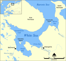
The district is elongated from west to east. The major part of the district belongs to the river basins of the Mezen (with the main tributaries, the Pyoza and the Kimzha) and the Kuloy (with the Nemnyuga and the Soyana), which both end up in the Mezen Bay of the White Sea. Areas on the White Sea coast drain directly into the sea, and some areas in the northeast of the district drain into the Pyosha River and other rivers of the Barents Sea basin.
Almost the whole of the district is covered by coniferous forests (taiga). The northern part of the district is transitional area between taiga and tundra (lesotundra). There are many glacial lakes across the district. The biggest lakes are east of the Mezen, Lake Varsh (shared with Nenets Autonomous Okrug), Lake Pocha, and Lake Vyzhletskoye.
The district also includes Morzhovets Island which separates the Mezen Bay from the entrance of the White Sea. The island is the only part of the district which lies above the Arctic Circle.
The part of the district located east of the Mezen is essentially unpopulated, with the exceptions of the right bank of the river and of several villages in the valley of the Pyoza.
Divisions
Administratively, the district is divided into thirteen selsoviets, one town (Mezen), and one urban-type settlement (Kamenka).[1] The following selsoviets have been established (the administrative centers are given in parentheses):
- Bychensky (Bychye)
- Dolgoshchelsky (Dolgoshchelye)
- Dorogorsky (Dorogorskoye)
- Koydensky (Koyda)
- Kozmogorodsky (Kozmogorodskoye)
- Lampozhensky (Lampozhnya)
- Moseyevsky (Moseyevo)
- Ruchyovsky (Ruchyi)
- Sovpolsky (Chizhgora)
- Soyansky (Soyana)
- Tselegorsky (Tselegora)
- Yolkinsky (Safonovo)
- Zherdsky (Zherd).
Municipal divisions
Municipally, the district is divided into two urban settlements and twelve rural settlements (the administrative centers are given in parentheses):[2]
- Mezenskoye Urban Settlement (Mezen);
- Kamenskoye Urban Settlement (Kamenka);
- Bychenskoye Rural Settlement (Bychye);
- Dolgoshchelskoye Rural Settlement (Dolgoshchelye);
- Dorogorskoye Rural Settlement (Dorogorskoye);
- Koydenskoye Rural Settlement (Koyda);
- Kozmogorodskoye Rural Settlement (Kozmogorodskoye);
- Moseyevskoye Rural Settlement (Moseyevo);
- Ruchyovskoye Rural Settlement (Ruchyi);
- Safonovskoye Rural Settlement (Safonovo);
- Sovpolskoye Rural Settlement (Chizhgora);
- Soyanskoye Rural Settlement (Soyana);
- Tselegorskoye Rural Settlement (Tselegora);
- Zherdskoye Rural Settlement (Zherd).
Restricted access
The northern part of the district is included into border security zone, intended to protect the borders of Russian Federation from unwanted activity. In particular, the town of Mezen, the urban-type settlement of Kamenka, and the whole White Sea coast within the district, including the settlements of Ruchyi, Koyda, and Dolgoshchelye, as well as Morzhovets Island, are included into this restricted area. In order to visit the zone, a permit issued by the local FSB department is required.[13]
Economy
Agriculture
Historically, fishery was the main source of income in the White Sea coast. The selo of Dolgoshchelye in the estuary of the Kuloy River was the main harbor of fishermen. In Soviet times, the fishery in the Arctic Ocean was state-sponsored; after 1990 the funds were cut, and the fishery went into decline.[14]
The special breed of horses, Mezen horse, was bred in the Mezen River valley. The Mezen horses are rather small but suitable for difficult work and easily survive cold winters.[15]
Transport
Both the Mezen and the Kuloy Rivers are navigable within the district limits; however, there is no passenger navigation except for the ferry boats across the rivers. Until 2008, there were no all-seasonal roads in the district. During winter, temporary roads (zimniks) are built in snow; in summer, the air transport is the only means for passenger connections to Arkhangelsk and the rest of the world. Currently, there is one all-seasonal road which connects the selo of Kimzha with Arkhangelsk via Pinega, and two branches from this road along the right bank of the Mezen. One branch runs north to the town of Mezen, whereas the second one runs south to the selo of Leshukonskoye.
There is an airport in Mezen, with several weekly flights to Arkhangelsk. There is also the airport in Kamenka.[16]
The majority of the villages of the district are not connected by all-season roads to the main road network, and the only means of getting to Mezen and Arkhangelsk is by air.
Culture and recreation
The district contains two objects classified as cultural and historical heritage by Russian Federal law, and additionally a number of objects classified as cultural and historical heritage of local importance.[17] The objects under federal protection are the wooden bell tower in the selo of Dolgoshchelye (burnt down in 1994 and does not exist anymore)[14] and the wooden Hodegetria Church in the selo of Kimzha (1709, currently disassembled). The objects under local protection are wooden churches, chapels, windmills, peasant and merchant houses.
The only state museum in the district is the Mezen Regional Museum, located in the town of Mezen.[18]
References
Notes
- ^ a b c d Государственный комитет Российской Федерации по статистике. Комитет Российской Федерации по стандартизации, метрологии и сертификации. №ОК 019-95 1 января 1997 г «Общероссийский классификатор объектов административно-территориального деления. Код 11 242», в ред. изменения №168/2011 от 1 октября 2011 г. (State Statistics Committee of the Russian Federation. Committee of the Russian Federation on Standardization, Metrology, and Certification. #OK 019-95 January 1, 1997 Russian Classification of Objects of Administrative Division . Code 11 242, as amended by the Amendment #168/2010 of October 1, 2011. ).
- ^ a b c d Law #258-vneoch.-OZ
- ^ "МЕЗЕНСКИЙ РАЙОН" (in Russian). Двина-Информ. http://www.dvinainform.ru/clients/36/. Retrieved 3 August 2011.
- ^ a b Федеральная служба государственной статистики (Federal State Statistics Service) (2011). "Предварительные итоги Всероссийской переписи населения 2010 года (Preliminary results of the 2010 All-Russian Population Census)" (in Russian). Всероссийская перепись населения 2010 года (All-Russia Population Census of 2010). Federal State Statistics Service. http://www.perepis-2010.ru/results_of_the_census/results-inform.php. Retrieved 2011-04-25.
- ^ a b Федеральная служба государственной статистики (Federal State Statistics Service) (2004-05-21). "Численность населения России, субъектов Российской Федерации в составе федеральных округов, районов, городских поселений, сельских населённых пунктов – районных центров и сельских населённых пунктов с населением 3 тысячи и более человек (Population of Russia, its federal districts, federal subjects, districts, urban localities, rural localities—administrative centers, and rural localities with population of over 3,000)" (in Russian). Всероссийская перепись населения 2002 года (All-Russia Population Census of 2002). Federal State Statistics Service. http://www.perepis2002.ru/ct/doc/1_TOM_01_04.xls. Retrieved 2010-03-23.
- ^ The value of density was calculated automatically by dividing the 2010 Census population by the area specified in the infobox. Please note that this value may not be accurate as the area specified in the infobox does not necessarily correspond to the area of the entity proper or is reported for the same year as the population.
- ^ Правительство Российской Федерации. Постановление №725 от 31 августа 2011 г. «О составе территорий, образующих каждую часовую зону, и порядке исчисления времени в часовых зонах, а также о признании утратившими силу отдельных Постановлений Правительства Российской Федерации». Вступил в силу по истечении 7 дней после дня официального опубликования. Опубликован: "Российская Газета", №197, 6 сентября 2011 г. (Government of the Russian Federation. Resolution #725 of August 31, 2011 On the Composition of the Territories Included into Each Time Zone and on the Procedures of Timekeeping in the Time Zones, as Well as on Abrogation of Several Resolutions of the Government of the Russian Federation. Effective as of after 7 days following the day of the official publication).
- ^ Архангельское областное Собрание депутатов. Областной закон №65-5-ОЗ от 23 сентября 2009 г. «Об административно-территориальном устройстве Архангельской области», в ред. Областного закона №150-12-ОЗ от 4 мая 2010 г «О внесении изменений и дополнений в отдельные областные законы». Вступил в силу через десять дней со дня официального опубликования. Опубликован: "Волна", №43, 6 октября 2009 г. (Arkhangelsk Oblast Council of Deputies. Oblast Law #65-5-OZ of September 23, 2009 On the Administrative and Territorial Structure of Arkhangelsk Oblast, as amended by the Oblast Law #150-12-OZ of May 4, 2010 On Amending and Supplementing Certain Oblast Laws. Effective as of the day ten days after the official publication).
- ^ "Всесоюзная перепись населения 1989 г. Численность наличного населения союзных и автономных республик, автономных областей и округов, краёв, областей, районов, городских поселений и сёл-райцентров. (All Union Population Census of 1989. Present population of union and autonomous republics, autonomous oblasts and okrugs, krais, oblasts, districts, urban settlements, and villages serving as district administrative centers.)" (in Russian). Всесоюзная перепись населения 1989 года (All-Union Population Census of 1989). Demoscope Weekly (website of the Institute of Demographics of the State University—Higher School of Economics. 1989. http://demoscope.ru/weekly/ssp/rus89_reg.php. Retrieved 2010-03-23.
- ^ Иванова, Т. Г. (2003). К истории региона. Былины Мезени: Север Европейской России.. Былины (Свод русского фольклора). 25. Saint-Petersburg: Наука. pp. 7—11. http://feb-web.ru/feb/byliny/texts/bl3/bl3-0073.htm. Retrieved 5 August 2011.
- ^ Энциклопедия Города России. Moscow: Большая Российская Энциклопедия. 2003. p. 256. ISBN 5-7107-7399-9.
- ^ "Лешуконский район" (in Russian). Лешуконский муниципальный район. http://www.leshukonia.ru/11.html. Retrieved 1 August 2011.
- ^ "Приказ ФСБ РФ от 2 июня 2006 года N 237 "О пределах пограничной зоны на территории Архангельской области"" (in Russian). Rossiyskaya Gazeta 2006. http://www.mccme.ru/putevod/Border/border.html.
- ^ a b Глезеров, Сергей (27 August 2002). "Сказка о потерянном рае, или как живётся в Долгощелье" (in Russian). Невское время (Saint-Petersburg). http://www.nvspb.ru/stories/skazka_o_poteryannom_rae_ili_k/?version=print. Retrieved 6 August 2011.
- ^ Мезенская лошадь. Great Soviet Encyclopedia. http://bse.sci-lib.com/article075114.html.
- ^ "Аэропорт Каменка" (in Russian). МойАрхангельск.Ру. http://myarkhangelsk.ru/adresa/8/394/. Retrieved 5 August 2011.
- ^ "Памятники истории и культуры народов Российской Федерации" (in Russian). Russian Ministry of Culture. http://kulturnoe-nasledie.ru/. Retrieved 5 August 2011.
- ^ "Мезенский историко-краеведческий музей" (in Russian). Российская сеть культурного наследия. http://www.museum.ru/M938. Retrieved 5 August 2011.
Sources
- Архангельское областное Собрание депутатов. Областной закон №65-5-ОЗ от 23 сентября 2009 г. «Об административно-территориальном устройстве Архангельской области», в ред. Областного закона №150-12-ОЗ от 4 мая 2010 г «О внесении изменений и дополнений в отдельные областные законы». Вступил в силу через десять дней со дня официального опубликования. Опубликован: "Волна", №43, 6 октября 2009 г. (Arkhangelsk Oblast Council of Deputies. Oblast Law #65-5-OZ of September 23, 2009 On the Administrative and Territorial Structure of Arkhangelsk Oblast, as amended by the Oblast Law #150-12-OZ of May 4, 2010 On Amending and Supplementing Certain Oblast Laws. Effective as of the day ten days after the official publication).
- Архангельское областное Собрание депутатов. Областной закон №258-внеоч.-ОЗ от 23 сентября 2004 г. «О статусе и границах территорий муниципальных образований в Архангельской области (текст в ред. от 15 февраля 2010 г.)», в ред. Областного закона №309-23-ОЗ от 7 июля 2011 г «О внесении изменений и дополнений в отдельные Областные законы в сфере организации и осуществления местного самоуправления». Вступил в силу со дня официального опубликования. Опубликован: "Волна", №38, 8 октября 2004 г. (Arkhangelsk Oblast Council of Deputies. Oblast Law #258-vneoch.-OZ of September 23, 2004 On the Status and Borders of the Territories of the Municipal Formations in Arkhangelsk Oblast (text of rev. of February 15, 2010), as amended by the Oblast Law #309-23-OZ of July 7, 2011 On Amending and Supplementing Several Oblast Laws on the Subject of Organization and Implementation of the Local Self-Government. Effective as of the day of the official publication).
External links
- "Официальный сайт муниципального образования "Мезенский муниципальный район" / Official website of the district" (in Russian). http://www.mezen.ru/. Retrieved August 3, 2011.
Administrative divisions of Arkhangelsk Oblast Administrative center: ArkhangelskCities and towns Arkhangelsk · Kargopol · Koryazhma · Kotlas · Mezen · Mirny · Naryan-Mar · Novodvinsk · Nyandoma · Onega · Severodvinsk · Shenkursk · Solvychegodsk · Velsk

Districts (raions) Kargopolsky · Kholmogorsky · Konoshsky · Kotlassky · Krasnoborsky · Lensky · Leshukonsky · Mezensky · Novaya Zemlya · Nyandomsky · Onezhsky · Pinezhsky · Plesetsky · Primorsky · Shenkursky · Solovetsky · Ustyansky · Velsky · Verkhnetoyemsky · Vilegodsky · VinogradovskyCategories:- Districts of Arkhangelsk Oblast


Wikimedia Foundation. 2010.