- Northern Dvina River
-
Coordinates: 64°32′00″N 40°29′00″E / 64.5333333°N 40.4833333°E
Northern Dvina
Russian: Се́верная Двина́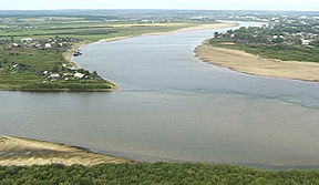
Northern Dvina starts as the confluence of Yug River (on left) and Sukhona River (on top) near Velikiy Ustyug (photo 2001)Origin Yug River and Sukhona River Mouth Dvina Bay Basin countries Russia Length 744 km (462 mi) Mouth elevation 0 Avg. discharge 3,332 cubic metres per second (117,700 cu ft/s)[1] Basin area 357,052 square kilometres (137,859 sq mi) 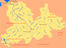 Map of the Northern Dvina basin
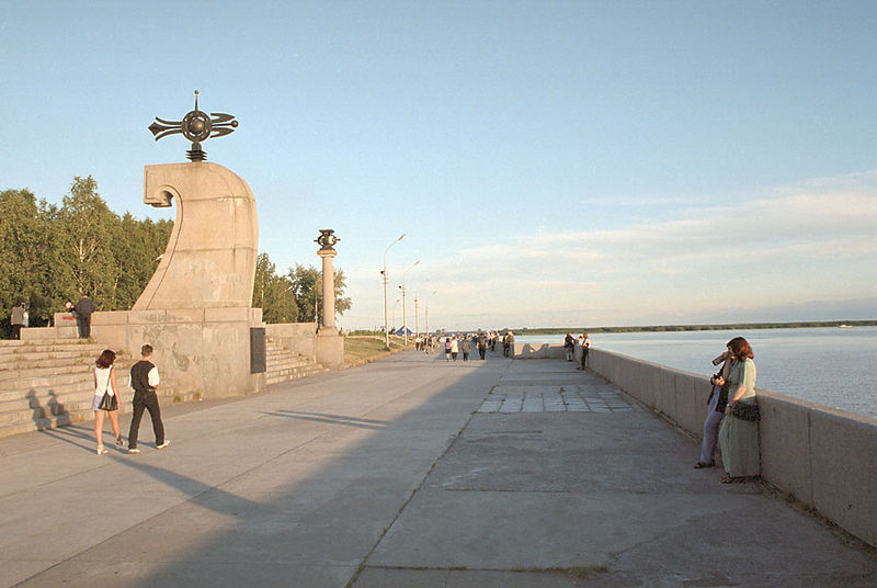
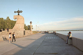 Northern Dvina Quay in Arkhangelsk
The Northern Dvina (Russian: Се́верная Двина́, IPA: [ˈsʲevʲɪrnəjə dvʲɪˈna]) is a river in Northern Russia flowing through the Vologda Oblast and Arkhangelsk Oblast into the Dvina Bay of the White Sea. Along with the Pechora River to the east, it drains most of Northwest Russia into the Arctic Ocean. It should not be confused with Western Dvina.
The principal tributaries of the Northern Dvina are the Vychegda (right), the Vaga (left), and the Pinega (right).
Contents
Etymology
According to the Max Vasmer's Etymological Dictionary, the name of the river has been transferred from the Western Dvina River. The toponym Dvina clearly can not stem originate from Finno-Ugric languages, however, its origin is unclear. Possibly it is an Indo-European word which used to mean river or stream.[2]
Physical geography
River basin
The length of the Northern Dvina is 744 kilometres (462 mi). Together with its major tributary, the Sukhona, it is 1,302 kilometres (809 mi) long – about as long as the Rhine River. The area of its basin is 357,052 square kilometres (137,859 sq mi) – about the size of the state of Montana. The river basin of the Northern Dvina include the major parts of the Vologda and the Arkhangelsk Oblasts, as well as areas in the western part of the Komi Republic and in the northern part of the Kirov Oblast, and minor areas in the north of Yaroslavl and Kostroma Oblasts. The cities of Arkhangelsk and Vologda, as well as many smaller towns, many of those of significant historical importance such as Veliky Ustyug, Totma, Solvychegodsk, and Kholmogory, are located in the river basin of the Northern Dvina.
The Northern Dvina basin is roughly T-shaped. The basin of 558 kilometres (347 mi) long Sukhona River, flowing east and joins the basin of the west-flowing Vychegda River (1,130 kilometres (700 mi) long). The combined stream flows northwest into the White Sea, which it joins near the city of Archangelsk. Looking more closely, the Sukhona flows east and meets the north-flowing Yug River at Veliky Ustyug. The combined stream, now called the Northern Dvina, flows north about 60 km and receives the west-flowing Vychegda at Kotlas and then turns northwest to flow into the White Sea. The Sukhona-Vychegda was an important east–west transportation route while the Northern Dvina-Yug was a north–south route. The upper Sukhona is now connected by the Northern Dvina Canal to the Volga–Baltic Waterway which links Petersburg to Moscow.
River course
The Sukhona River flows east, eventually north-east, joins the north-flowing Yug River at Veliky Ustyug and acquires the name 'Northern Dvina'. The P157 highway connecting Kostroma with Kotlas via Nikolsk and Veliky Ustyug. North of Veliky Ustyg, the highway runs on the left bank of the Northern Dvina. The river flows about 60 kilometres (37 mi) north crossing from the Vologda Oblast into the Arkhangelsk Oblast, where in the city of Kotlas it receives the west-flowing Vychegda River which rises in the northern Ural Mountains. Since at the confluence the length of the Vychegda is bigger than that of the Northern Dvina, the river between the source and the confluence with the Vychegda is sometimes known as the Lesser Northern Dvina (Russian: Малая Северная Двина). Shortly downstream from the confluence, the Northern Dvina is crossed by the railway connecting Konosha with Kotlas and Vorkuta.
The Northern Dvina then turns northwest and receives a number of smaller rivers like the Uftyuga River and the Nizhnyaya Toyma River, both from the northeast. Near the urban type settlement of Bereznik the Vaga River comes in from the south, as does the M8 highway which runs from Moscow through Vologda to Arkhangelsk. The Yomtsa or Yemtsa River and the P1 highway (from Kargopol) join from the southeast. The Pinega River, formerly an important river route, joins from the east. Near the mouth of the Pinega the river splits into several channels, among which is the ancient selo of Kholmogory 75 kilometres (47 mi) southeast of Arkhangelsk. The branches rejoin and pass the modern logging town of Novodvinsk. Downstream from Novodvinsk, the 900 square kilometres (350 sq mi) delta begins. In the upstream part of the delta the great port of Arkhangelsk is located which gradually replaced Kholmogory as the chief town of the region. On the southwest side of the delta is the naval base of Severodvinsk, the second largest city in the region. The delta ends in the Dvina Bay of the White Sea.
The river flows through Velikoustyugsky District of the Vologda Oblast and through Kotlassky, Krasnsoborky, Verkhnetoyemsky, Vinogradovsky, Kholmogorsky, and Primorsky Districts of the Arkhangelsk Oblast. All administrative centers of these districts are located at the banks of the Northern Dvina.
In summer the river is navigable all along and is heavily used for timber floating. The Northern Dvina Canal connects it with the Volga–Baltic Waterway. In the 19th century, a short-lived Northern Ekaterininsky Canal, now abandoned, connected the Northern Dvina basin with the Kama basin as well. In 1926—1928 a canal connecting the Pinega, one of the major tributaries of the Northern Dvina, with the Kuloy, was constructed, however, currently the canal is pretty much neglected.
History
 The Northern Dvina at the city of Kotlas. The picture is taken from the railway bridge; in front, there is the highway bridge
The area was originally populated by Finno-Ugric peoples and then colonized by the Novgorod Republic. The only exception was Veliky Ustyug, which was part of Vladimir-Suzdal Principality. The rest of the Northern Dvina basin was controlled by Novgorod. Veliky Ustyug has been first mentioned in the chronicles in 1207, Shenkursk — in 1315, Solvychegodsk was founded in 14th century. In the 13th century the Novgorod merchants already reached the White Sea. The area was attractive in the first instance because of the fur trading. The main waterway from Novgorod into the Northern Dvina was along the Volga and its tributary, the Sheksna, along the Slavyanka River into Lake Nikolskoye, then the boats were taken by land to Lake Blagoveshchenskoye, from there downstream along the Porozovitsa River into Lake Kubenskoye and further to the Sukhona and the Northern Dvina.[3]
From the Northern Dvina, there were a number of ways into the basin of the Mezen (from where the merchants could get to the basin of the Pechora and the Ob). One was upstream the Vychegda and the Yarenga, and by land into the Vashka. Another one was upstream the Vychegda, the Vym, the Yelva, then by land to the Irva and to the Mezen. Two further options included going upstream the Pinega, and then by land to the Kuloy and to the Mezen, or using the Pukshenga and the Pokshenga Rivers to get to the Pinega, and then from the Yezhuga taking boats by land to the Zyryanskaya Yezhuga and the Vashka.[3] From the Vychegda, the merchants also could get directly to the river basin of the Pechora via either the Cherya and the Izhma, or the Mylva.
From 14th century, Kholmogory was the main trading harbor on the Northern Dvina, but in 17th century it lost this distinction to Arkhangelsk (even though the seat of the Kholmogory and Vaga Eparchy, from 1732 known as Kholmogory and Archangelogorod Eparchy, which had jurisdiction over all Northern Russia including the Solovetsky Monastery, was located in Kholmogory until 1762. Until 1700s, Arkhangelsk was the main trading harbour for the sea trade of Russia and Western Europe, and the Northern Dvina was the main trading route connecting the central Russia with Arkhangelsk. Peter the Great drastically changed the situation, by founding Saint-Petersburg in 1703, thus opening the way for the Baltic Sea trade, and by constructing the highway between Saint-Petersburg and Arkhangelsk via Kargopol. The river quickly lost its role as the leading trading route, which was accelerated by the construction of the railway between Vologda and Arkhangelsk between 1894 and 1897.
The Northern Dvina was scene of several battles during the Russian Civil War, many involving the Entente interventionist army as part of their North Russia Campaign. A special Northern Dvina Flotilla existed during the Civil War.
From 1950s, the Northern Dvina was heavily used for timber rafting. The passenger navigation has been largely disappeared. Only local passenger lines remain. The passenger line connecting Kotlas and Arkhangelsk has been out of operation since 2005.
References
- ^ Dvina – Ust-Pinega
- ^ Фасмер, Макс (in Russian). Этимологический словарь Фасмера. p. 161. http://fasmerbook.com/p161.htm.
- ^ a b Плечко, Л.А. (1985) (in Russian). Старинные водные пути. Moscow: Физкультура и спорт. http://www.skitalets.ru/books/star_puti/.
External links
- Северная Двина. Great Soviet Encyclopedia. http://bse.sci-lib.com/article100524.html.
- A detailed article about Nortnern Dvina in the 1906 Brockhaus and Efron Encyclopedic Dictionary
- "Река Сев. Двина" (in Russian). State Water Register of Russia. http://textual.ru/gvr/index.php?card=158634. Retrieved 1 August 2011.
Categories:- Rivers of Arkhangelsk Oblast
- Rivers of Vologda Oblast
- Northern Dvina basin


Wikimedia Foundation. 2010.