- Nordvest-Spitsbergen National Park
-
Nordvest-Spitsbergen National Park 
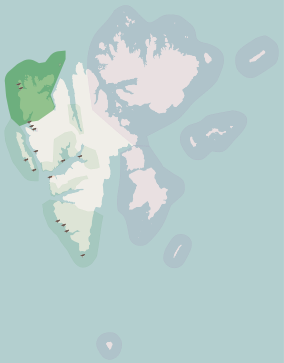
Location Svalbard, Norway Coordinates 79°35′N 11°30′E / 79.583°N 11.5°ECoordinates: 79°35′N 11°30′E / 79.583°N 11.5°E Area 9,914 km² (3,683 land; 6,231 marine) Established 1973 Governing body Directorate for Nature Management Nordvest-Spitsbergen National Park (Norwegian: Nordvest-Spitsbergen nasjonalpark) is located on the Norwegian archipelago of Svalbard and includes parts of northwest Spitsbergen (Albert I Land and Haakon VII Land) and nearby islands such as Danskøya and Moffen. The park was established by royal resolution on June 1, 1973, and contains, among other things, warm springs and remains of volcanoes in Bockfjorden.
The national park also contains innumerable colonies of seabirds, in addition to Svalbard reindeer and arctic fox. It is also a hibernating area for polar bears, and walrus can be found there. There are remains of whaling stations and graves from the 17th century. In addition there are remains of several Arctic expeditions, for instance in Virgohamna, Danskøya, the launching point for Swedish engineer S. A. Andrée's failed 1897 attempt to reach the North Pole in a hydrogen balloon.
Hot springs
The Troll and Jotun hot springs in the park along the edge of the Bockfjorden are the northernmost documented terrestrial hot springs on earth at almost 80 degrees north latitude. The first documentation of these springs was in the late 1800s. Hoel and Haltedahl[1] studied these two hot springs in some detail. They reported that the Jotun hot spring has a temperature of 24.5°C and the Troll hot spring has a temperature of 28.3°C.
External links
References
- ^ Lavadaekkerne, vulkanerne og de varme kilder ved Wood Bay paa Spitsbergen, A. Hoel, O. Haltedahl, Naturen 37, 3-19 (Oslo), 1913.
Svalbard General Politics Settlements Former settlements Bölscheøya · Grumant · Kobbefjorden · Lægerneset · Pyramiden · Smeerenburg · Virgohamna · Ytre NorskøyaEnvironment Islands Barentsøya · Bjørnøya · Edgeøya · Hopen · Kong Karls Land · Kvitøya · Nordaustlandet · Prins Karls Forland · Sjuøyane · Spitsbergen · Tusenøyane · WilhelmøyaLand areas Albert I Land · Andrée Land · Bünsow Land · Dickson Land · Haakon VII Land · Heer Land · James I Land · Nathorst Land · Nordenskiöld Land · Ny-Friesland · Olav V Land · Oscar II Land · Sabine Land · Sørkapp Land · Torell Land · Wedel Jarlsberg LandNational parks Forlandet National Park · Indre Wijdefjorden · Nordenskiöld Land · Nordre Isfjorden Land · Northwest Spitsbergen · Sassen – Bünsow Land · Sør-SpitsbergenCompanies Research Arctic Yellow River Station · Norwegian Polar Institute · Polish Polar Station · Seed Vault · Undersea Cable · University Centre · Himadri StationTransport National parks of Norway Mainland Ånderdalen · Blåfjella–Skjækerfjella · Breheimen · Børgefjell · Dovre · Dovrefjel–Sunndalsfjella · Femundsmarka · Folgefonna · Forollhogna · Gutulia · Hallingskarvet · Hardangervidda · Jostedalsbreen · Jotunheimen · Junkerdal · Langsua · Lierne · Lomsdal–Visten · Møysalen · Øvre Anárjohka · Øvre Dividal · Øvre Pasvik · Rago · Reinheimen · Reisa · Rohkunborri · Rondane · Saltfjellet–Svartisen · Seiland · Sjunkhatten · Skarvan and Roltdalen · Stabbursdalen · Varangerhalvøya · Ytre Hvaler
Svalbard Forlandet · Indre Wijdefjorden · Nordenskiöld Land · Nordre Isfjorden · Nordvest-Spitsbergen · Sassen – Bünsow Land · Sør-SpitsbergenFormer 
This article related to a protected area in Europe is a stub. You can help Wikipedia by expanding it.

