- Milltown Malbay
-
Milltown Malbay
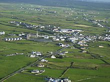
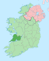
Sráid na Cathrach— Town — Location in Ireland Coordinates: 52°51′N 9°24′W / 52.85°N 9.4°WCoordinates: 52°51′N 9°24′W / 52.85°N 9.4°W Country Ireland Province Munster County County Clare Elevation 20 m (66 ft) Population (2006) - Urban 570 Time zone WET (UTC+0) - Summer (DST) IST (WEST) (UTC-1) Irish Grid Reference R054791 Milltown Malbay (Irish: Sráid na Cathrach, meaning "street of the stone ringfort")[1] is a town and parish in the west of County Clare, Ireland, near Spanish Point.
Contents
Name
There is a townland on the southern edge of the town called Poulawillin or Pollawillin (from Irish: Poll a' Mhuillinn, meaning "hole/pool of the mill"). There is evidence that this name was once applied to the town – for example, in the Parish Namebook of the Ordnance Survey (1839) there is a reference to "Baile an Mhuillinn anciently Poll a’ Mhuillinn, Milltown Malbay".[1]
Malbay is the name of the bay to the west of Milltown. The name Malbay is thought to come from the Irish meall-bhaigh, which roughly means "treacherous coast". It could also stem from the legend of the witch "Mal" who was drowned in the bay by Fionn mac Cumhaill.[citation needed]
Business
The main sources of employment in the area are tourism & hospitality, construction and agriculture.
The town has thirteen good quality pubs. Other businesses are amongst other several supermarkets, a hostel, hardware shop, bridal shop, a bookmaker's office, a Chinese restaurant/takeaway, a pizzeria, a clothes shop, a surf shop and a barber's shop. There are two pharmacies and two restaurants in the town. Lyons Travel is the main coach hire business in the area.
There are two large hotels in the parish, the Armada Hotel and The Bellbridge Hotel. There are numerous B & Bs in Milltown and its surrounding area.
Transport
Milltown Malbay was served by the West Clare Railway, which operated from the 2 July 1887 and finally closed on 1 February 1961.[2]
Spanish Point Airfield
Spanish Point Airfield IATA: none – ICAO: EISP Summary Location Milltown Malbay, Spanish Point,
County Clare, IrelandElevation AMSL 17 ft / 5 m Coordinates 52°51′00″N 09°25′00″W / 52.85°N 9.4166667°W Runways Direction Length Surface m ft 24/06 580 2,165 Grass http://www.gcmap.com/airport/EISP Spanish Point Airfield is an privately owned airfield between Milltown Malbay and Spanish Point. The airfield, located on Sandhill Road in the townland Leagard South, was established by three local pilots in 1991, and the original clubhouse was opened by then Irish Minister for Defense Mr. Brendan Daly that year.
The airfield has a single 580m grass runway (coded: 24/06), that is serviceable for approximately 10 months of the year. It has a clubhouse and hangarage for a number of aircraft. It also possesses two landing pads for rotary winged aircraft. The airfield is mainly used by small aircraft, microlights and helicopters.
Education
There are 4 primary schools and 1 secondary school in the parish. The primary schools are Milltown Malbay National School (in town), Rockmount National School (N.S.), Rineen N.S. and Moy N.S. (gaelscoil). The secondary school is St Joseph's Secondary School, Spanish Point. St Joseph's draws pupils from the parishes of Milltown Malbay, Kilmurry Ibrickane, Doonbeg, Inagh and Cooraclare.
Oidhreacht an Chláir Teo
Oidhreacht an Chláir Teo (English: Clare Institute for Traditional Studies) is a research institution located on Flag Road. Its main field of work is research and stimulation of the traditional culture in County Clare.
Oidhreacht an Chláir Teo tries to reach her goals by the following ways:
“ -the establishment of an institute for education in the traditional culture of Clare, directed primarily towards the higher education and lifelong learning sectors
-the provision of a permanent, easily accessible, archive and library for material relevant to the traditional arts in general and, in particular, to the abundant material of local relevance
-the provision of a performance centre and associated facilities” The main target of the Institute are researchers, local people and students.[4]
GAA
Milltown is home to St. Joseph's Miltown Malbay GAA Club, Clonbony GAA club and Moy GAA club. St. Joseph's are the only senior team in the parish. They have won the County Clare Senior Football Championship on 12 occasions with the latest win in 1990. It has teams in Senior, Junior A, U21, U18, U16, U14, U12, U10 and U8. It also has ladies' teams with Senior, Junior, Minor, U16 and U14.
Willie Clancy
The town is home to the annual Willie Clancy Summer School and Festival. The Willie Clancy Summer School (Irish Scoil Samhraidh Willie Clancy) is Ireland's largest traditional music summer school[5] held annually since 1973 in memory of and to honour the uilleann piper Willie Clancy.
History
The town has only existed since about 1800 but grew rapidly: by 1821 it had a population of 600. During the Great Famine (1844 - 1848) many farmers were evicted by the unpopular landlord Moroney. In the years after the famine the (protestant) Moroney family went on with rack renting and evictions. At one time the population had enough and started a boycott. The government did not like that and imprisoned al pub-owners and shopkeepers who refused to serve the family or their servant. So at the end of 1888 most pub-owners and shopkeepers were in jail.[6]
Milltown is also home to the site of the Rineen Ambush which is located near Rineen on the main road to Lahinch and Ennistymon. On September 22, 1920 a RIC tender was ambushed there by Mid-Clare Brigade IRA mainly in retaliation for the killing of Martin Devitt at Crow's Bridge earlier in the year. The ambush led to the deaths of six policemen. In reprisal for Rineen Ambush, the RIC ran amok in Ennistymon, Lahinch and Milltown Malbay killing six people and burning 26 buildings, including Ennistymon and Lahinch Townhalls.
The Atlantic Hotel was one of the victims of the War of Independence. Owned by the Moroney family and mainly visited by English gentry it had no future and closed down around 1925.[7]
Population
The town had a population of 570 according to the 2006 Census. Including the rural area around the town it counts 1,555 inhabitants.
Historical populations Year Pop. ±% 1821 600 — 1831 726 +21.0% 1841 1,295 +78.4% 1851 1,452 +12.1% 1861 1,339 −7.8% 1871 1,362 +1.7% 1881 1,100 −19.2% 1891 1,267 +15.2% 1901 1,013 −20.0% 1911 995 −1.8% 1926 788 −20.8% 1936 809 +2.7% 1946 732 −9.5% 1951 668 −8.7% 1956 782 +17.1% 1961 700 −10.5% 1966 721 +3.0% 1971 677 −6.1% 1981 726 +7.2% 1986 719 −1.0% 1991 615 −14.5% 1996 626 +1.8% 2002 562 −10.2% 2006 570 +1.4% <[8][9][10][11][12][13] Notable people
- Aindrias Mac Cruitín (Andrew MacCurtin) (c.1670–1738) - poet and scribe.
- Dr. Patrick Hillery - President of Ireland 1976-1990, was born at Spanish Point near Milltown Malbay in 1923.
- Matthew Joseph Kenny - lawyer and politician
- Chief Superintendent Anthony McMahon - founder and former head of the Murder Squad of An Garda Siochana and Irish Liaison to Interpol was born in Milltown Malbay. He was responsible for the hiring of the country's first State Pathologist, Dr John Harbison.
- Seán Óg - Singer and musician
- Colonel Noel S. Walsh (1935) was Commanding Officer of the First Battalion of the Irish Army and former Chairman of the Munster Council of the Gaelic Athletic Association
- musicians and singers
- Willie Clancy - (1918–1973), uilleann piper
- Junior Crehan - fiddler player
- Kitty Hayes - concertina player
- Nonie Lynch - traditional singer
Trivia
- In 2009 Andrea Corr from The Corrs got married to Brett Desmond in St. Joseph's Church.
Gallery
See also
References
- ^ a b Placenames Database of Ireland: Milltown Malbay/Sráid na Cathrach
- ^ "Miltown Malbay station". Railscot - Irish Railways. http://www.railscot.co.uk/Ireland/Irish_railways.pdf. Retrieved 2007-11-04.
- ^ About OaC
- ^ About OaC
- ^ Festival in danger due to cutbacks Last visited 21-11-2009.
- ^ Milltown Malbay Historical Background
- ^ Paddy Casey, lecture for the "Kilfarboy Historical Society, 13-10-2009.
- ^ For 1653 and 1659 figures from Civil Survey Census of those years, Paper of Mr Hardinge to Royal Irish Academy March 14, 1865.
- ^ Census for post 1821 figures.
- ^ http://www.histpop.org
- ^ http://www.nisranew.nisra.gov.uk/census
- ^ Lee, JJ (1981). "On the accuracy of the Pre-famine Irish censuses". In Goldstrom, J. M.; Clarkson, L. A.. Irish Population, Economy, and Society: Essays in Honour of the Late K. H. Connell. Oxford, England: Clarendon Press.
- ^ Mokyr, Joel; O Grada, Cormac (November). "New Developments in Irish Population History, 1700-1850". The Economic History Review Volume 37 (Issue 4): 473–488. doi:10.1111/j.1468-0289.1984.tb00344.x. http://www3.interscience.wiley.com/journal/120035880/abstract
Places in County Clare County town: Ennis Towns Villages Ardnacrusha · Aughinish · Ballynacally · Ballyvaughan · Barefield · Bodyke · Bridgetown · Broadford · Cahiracon · Carrigaholt · Clarecastle · Clonlara · Cloonanaha · Connolly · Cooraclare · Coore · Corofin · Cratloe · Cree · Cross · Crusheen · Doolin · Doonaha · Doonbeg · Ennistymon · Fanore · Feakle · Hurlers Cross · Inagh · Ivarstown · Kilbaha · Kildysart · Kilfenora · Kilkishen · Killaloe · Killimer · Kilmihil · Kilnamona · Knock · Labasheeda · Lahinch · Liscannor · Lisdoonvarna · Lisseycasey · Meelick · Milltown Malbay · Mountshannon · Mullagh · Murroogh · Newmarket-on-Fergus · O'Brien's Bridge · O'Callaghans Mills · Parteen · Quilty · Quin · Ruan · Scarriff · Sixmilebridge · Spancill Hill · Spanish Point · Tuamgraney · Tulla · WhitegateTownlands Ardsallis · Ballaghline · Burren · Coolmeen · Deer Island · Drumcliff · Inis Cathaig (or Scattery Island) · Ogonnelloe · TulligList of townlands in County Clare · Category:Mountains and hills of County Clare · Category:Rivers of County Clare · Category:Geography of County Clare Categories:- Towns and villages in County Clare
Wikimedia Foundation. 2010.


