- Shannon, County Clare
Infobox Irish Place
name = Shannon
gaeilge = An tSionna
crest
motto =
map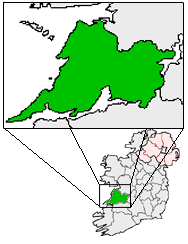
pin coords = left: 110px; top: 90px
north coord = 52.713731
west coord = 8.868628
irish grid = R402624
area =
elevation = sea level
province =Munster
county =County Clare
town pop = 9,222
rural pop =
census yr = 2006
web = www.shannon.ie
|Shannon or Shannon Town ("An tSionna" in Irish), named after the river near which it stands, is a
new town located inCounty Clare and is one of only three planned towns on the island ofIreland , the others being theNorthern Ireland town ofCraigavon and the Mayo village of Westport. It was given town status on 1 January 1982. The town is located just off theN19 road , a spur of theN18 road betweenLimerick andEnnis .The town is administered at a local level by Shannon
Town Council , known prior to 2001 as Shannon Town Commissioners. [http://www.shannon.ie/stcmeetings/stc_origins.html] In addition, prior to September 2004,Shannon Development , a state-sponsored body had charge of many services normally provided by local authorities in theRepublic of Ireland . This gave Shannon a unique status in local governance. In September 2004 its situation was regularised when Shannon Development transferred its local government functions toClare County Council . [http://www.shannondevelopment.ie/NewsReleases/Documents/filename,2304,en.pdf] . The company retains responsibility for theShannon Free Zone .The town was built on reclaimed
marshland alongside the newly establishedShannon Airport , along with theShannon Free Zone industrial estate . The town itself was intended as a home for the thousands of workers at the airport, surrounding industries and support services. Population growth was never as fast as planned throughout the first few decades of the town's existence. This was partly due to the proximity of 'friendly' places to live, such asEnnis andLimerick City , or even the nearby village ofNewmarket-on-Fergus .The 'planned' nature of this town did not necessarily result in a successful town. Until 2003 the main
dual-carriageway to the airport divided the town, as well as cutting it off from the surrounding countryside. Much of the town layout was car-oriented, with straight roads and rigidly laid out housing, rather than people-friendly design. As well as generally lacking in facilities, the town'sshopping centre was also of dubious design. Shops fronted onto pedestrian malls that were originally uncovered, allowing estuary winds and rain to strike at shoppers. There is a marked difference too between the early low-cost housing (tower block flats located inDrumgeely near the airport and terraced housing) and high-cost housing (large detached housing) located on the outskirts inBallycasey towardsLimerick City .The future for the town is brighter than it has been for many years. The recently completed bypass of
Newmarket on Fergus also includes a spur to Shannon airport, resulting in a bypass of the town for most traffic to and from Ennis and Limerick. The population grew significantly in the 1990s, and new modern housing developments continue to be built. As a result, facilities in the town are slowly improving; for example, a second majorsupermarket opened, with the shopping centre being expanded by the addition of the modern "Skycourt" complex. The main road through Shannon was remodelled following the opening of the bypass. New units continue to open in the industrial estates (despite some others closing or changing hands). There is also a lobby forrailway services connecting to Shannon, from the existing Ennis-Limerick route. In theory this would benefit the local community as well as the airport.ee also
*
List of towns in the Republic of Ireland External links
* [http://www.shannon.ie Official site]
Wikimedia Foundation. 2010.