- Microregion of Birigüi
-
Microregion of
Birigüi— Microregion — Location of the Microregion of Birigüi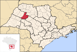
Coordinates: 21°17′19″S 50°20′24″W / 21.28861°S 50.34°WCoordinates: 21°17′19″S 50°20′24″W / 21.28861°S 50.34°W Country  Brazil
Region Southeast State  São Paulo
Mesoregion Araçatuba Area – Total 4,510.9 km2 (1,741.7 sq mi) Population (2010/IBGE) – Total 257,531 – Density 57.09/km2 (147.9/sq mi) Time zone UTC-3 (UTC-3) – Summer (DST) UTC-2 (UTC-2) Postal Code 16200-000 Area code(s) +55 18 The Microregion of Birigüi (Portuguese: Microrregião de Birigüi) is located on the northwest of São Paulo state, Brazil, and is made up of 18 municipalities. It belongs to the Mesoregion of Araçatuba.
The population of the Microregion is 257,531 inhabitants, in an area of 4,510.9 km²[1]
Municipalities
Cities and population (IBGE/2010)[2]
- Alto Alegre: 4,102
- Avanhandava: 11,310
- Barbosa: 6,593
- Bilac: 7,048
- Birigüi: 108,728
- Braúna: 5,021
- Brejo Alegre: 2,573
- Buritama: 15,418
- Clementina: 7,065
- Coroados: 5,238
- Gabriel Monteiro: 2,708
- Glicério: 4,565
- Lourdes: 2,128
- Luiziânia: 5,030
- Penápolis: 58,510
- Piacatu: 5,287
- Santópolis do Aguapeí: 4,277
- Turiúba: 1,930
References
- ^ "2010 Census of the IBGE - Synopsis - Tables 761 and 1301" (in Portuguese). IBGE.gov.br. http://www.sidra.ibge.gov.br/cd/cd2010sp.asp?o=3&i=P. Retrieved 29 July 2011.
- ^ "2010 Census of the IBGE - Population - Table 2.1.20". IBGE.gov.br. http://www.ibge.gov.br/home/estatistica/populacao/censo2010/tabelas_pdf/Sao_paulo.pdf. Retrieved 29 July 2011.
Mesoregions Araçatuba • Araraquara • Assis • Bauru • Campinas • Itapetininga • Litoral Sul Paulista • Macro Metropolitan Paulista • Marília • Metropolitan São Paulo • Piracicaba • Presidente Prudente • Ribeirão Preto • São José do Rio Preto • Vale do Paraíba PaulistaMicroregions Adamantina • Amparo • Andradina • Araçatuba • Araraquara • Assis • Auriflama • Avaré • Bananal • Barretos • Batatais • Bauru • Birigui • Botucatu • Bragança Paulista • Campinas • Capão Bonito • Campos do Jordão • Caraguatatuba • Catanduva • Dracena • Fernandópolis • Franca • Franco da Rocha • Guaratinguetá • Guarulhos • Itanhaém • Itapecerica da Serra • Itapetininga • Itapeva • Ituverava • Jaboticabal • Jales • Jaú • Jundiaí • Limeira • Lins • Marília • Mogi das Cruzes • Mogi-Mirim • Nhandeara • Novo Horizonte • Osasco • Ourinhos • Paraibuna e Paraitinga • Paulínia • Piedade • Piracicaba • Pirassununga • Presidente Prudente • Registro • Ribeirão Preto • Rio Claro • Santos • São Carlos • São João da Boa Vista • São Joaquim da Barra • São José dos Campos • São José do Rio Preto • São Paulo • Sorocaba • Tatuí • Tupã • VotuporangaDemographics of Brazil Economic and social Apartheid · Attractions · Law · Crime · Education · GDP · Health · Human Development · Human Rights (LGBT Rights) · Immigration · Languages · People · Politics · Poverty · Races · Religions · Traditions · Wealth
Ethnic groups BrazilAfricaAmericasNorth AmericaCaribbeanHaitianSouth AmericaBy EthnicityBy Country
or RegionEasternSouthernEast IndianWesternEuropeBy EthnicityBy Country
or RegionNorthernWesternCentralSouthernBalkanEasternCategories:- Microregions of São Paulo (state)


Wikimedia Foundation. 2010.