- Microregion of São Carlos
-
Microregion of
São Carlos— Microregion — Location of the Microregion of São Carlos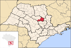
Coordinates: 22°01′04″S 47°53′27″W / 22.01778°S 47.89083°WCoordinates: 22°01′04″S 47°53′27″W / 22.01778°S 47.89083°W Country  Brazil
Region Southeast State  São Paulo
Mesoregion Araraquara Area - Total 3,185.4 km2 (1,229.9 sq mi) Population (2010/IBGE) - Total 308,777 - Density 96.94/km2 (251.1/sq mi) Time zone UTC-3 (UTC-3) - Summer (DST) UTC-2 (UTC-2) Postal Code 14000-000 Area code(s) +55 16 The Microregion of São Carlos (Portuguese: Microrregião de São Carlos) is located on the east-center of São Paulo state, Brazil, and is made up of 6 municipalities. It belongs to the Mesoregion of Araraquara.
The population of the Microregion is 308,777 inhabitants, in an area of 3,185.4 km²[1]
Municipalities
Cities and population (IBGE/2010)[2]
- Analândia: 4,293
- Descalvado: 31,056
- Dourado: 8,609
- Ibaté: 30,734
- Ribeirão Bonito: 12,135
- São Carlos: 221,950
References
- ^ "2010 Census of the IBGE - Synopsis - Tables 761 and 1301" (in Portuguese). IBGE.gov.br. http://www.sidra.ibge.gov.br/cd/cd2010sp.asp?o=3&i=P. Retrieved 22 July 2011.
- ^ "2010 Census of the IBGE - Population - Table 2.1.20". IBGE.gov.br. http://www.ibge.gov.br/home/estatistica/populacao/censo2010/tabelas_pdf/Sao_paulo.pdf. Retrieved 22 July 2011.
Mesoregions Araçatuba • Araraquara • Assis • Bauru • Campinas • Itapetininga • Litoral Sul Paulista • Macro Metropolitan Paulista • Marília • Metropolitan São Paulo • Piracicaba • Presidente Prudente • Ribeirão Preto • São José do Rio Preto • Vale do Paraíba PaulistaMicroregions Adamantina • Amparo • Andradina • Araçatuba • Araraquara • Assis • Auriflama • Avaré • Bananal • Barretos • Batatais • Bauru • Birigui • Botucatu • Bragança Paulista • Campinas • Capão Bonito • Campos do Jordão • Caraguatatuba • Catanduva • Dracena • Fernandópolis • Franca • Franco da Rocha • Guaratinguetá • Guarulhos • Itanhaém • Itapecerica da Serra • Itapetininga • Itapeva • Ituverava • Jaboticabal • Jales • Jaú • Jundiaí • Limeira • Lins • Marília • Mogi das Cruzes • Mogi-Mirim • Nhandeara • Novo Horizonte • Osasco • Ourinhos • Paraibuna e Paraitinga • Paulínia • Piedade • Piracicaba • Pirassununga • Presidente Prudente • Registro • Ribeirão Preto • Rio Claro • Santos • São Carlos • São João da Boa Vista • São Joaquim da Barra • São José dos Campos • São José do Rio Preto • São Paulo • Sorocaba • Tatuí • Tupã • VotuporangaDemographics of Brazil Economic and social Apartheid · Attractions · Law · Crime · Education · GDP · Health · Human Development · Human Rights (LGBT Rights) · Immigration · Languages · People · Politics · Poverty · Races · Religions · Traditions · Wealth
Ethnic groups BrazilAfricaAmericasNorth AmericaCaribbeanHaitianSouth AmericaBy EthnicityBy Country
or RegionEasternSouthernEast IndianWesternEuropeBy EthnicityBy Country
or RegionNorthernWesternCentralSouthernBalkanEasternCategories:- Microregions of São Paulo (state)


Wikimedia Foundation. 2010.