- Microregion of Caraguatatuba
-
Microregion of
Caraguatatuba— Microregion — Location of Microregion of Caraguatatuba in the state of São Paulo
Country  Brazil
Region Southeast State  São Paulo
Mesoregion Mesoregion of Vale do Paraíba Paulista Time zone UTC-3 (UTC-3) - Summer (DST) UTC-2 (UTC-2) 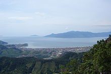 Caraguatatuba (foreground) and the northern half of Ilhabela (background): two cities of Litoral Norte.
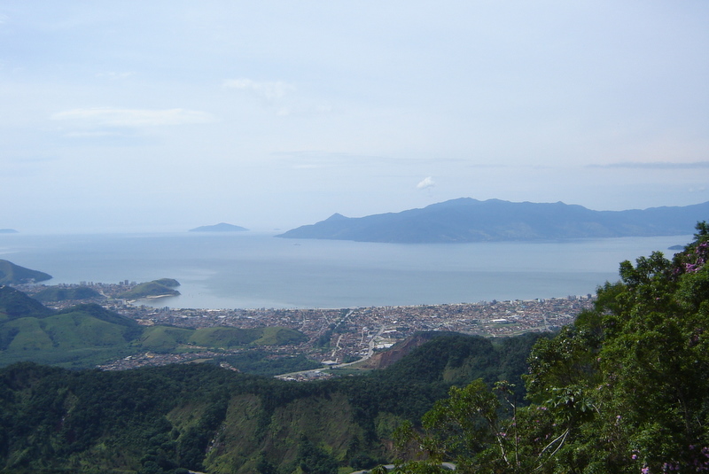
The Microregion of Caraguatatuba (Portuguese: Microrregião de Caraguatatuba), often referred as Litoral Norte (Northern Coastline), is a microregion in the easternmost coastal part of São Paulo State, Brazil, and comprises the cities of Caraguatatuba, Ilhabela, São Sebastião, Ubatuba. The microregion is bordered by the state of Rio de Janeiro to the east. It is a famous touristic destination, mainly because of the 160 beaches. According to IBGE, Caraguatatuba microregion has a GDP of R$2.019.943.048,00 and a population of 281.532 people spread over an area of 1.947,702 km², which means that the density is 144,5/km². The population main increase considerably during the summer, because of the tourists.
Contents
History
The first city to be settled was São Sebastião, in 1636. Ubatuba came next, in 1637, and then Ilhabela in 1805. Caraguatatuba was the last one, in 1857. However, it is important to note that the channel between Ilhabela and São Sebastião had already been sailed by the Portuguese in 1502.
All four cities relied on agriculture and fishing as its main economic activities for most of the 17th, 18th and 19th centuries, whereas São Sebastião served as a major sugar cane, coffea and tobacco production site. In the second half of the 20th century, the cities started to receive several tourists, mostly from São Paulo and nearby cities. This made it possible for the region to make money out of tourism, via hotels, restaurants, handicraft stores and nightclubs.
Geography
The Serra do Mar mountain range dominates the landscape of the microregion. Urbanization took place in the plains between the mountains and the sea. The highest point is the Pico de São Sebastião (Saint Sebastian's Peak), in Ilhabela, at 1.378m above sea level. The Oceanic climate sets the temperatures around the region between 20º-30ºC for most of the year. Rain falls moderately, but it falls more frequently particularly in Ubatuba, which is the reason of the city's nickname Ubachuva (lit. Ubarain).
Transportation
Highways
The only road crossing all the microregion (except for the non-continental municipality Ilhabela) is the BR-101, which runs near the sea and serves as the main connection between the cities. São Sebastião is the only city not to have a connection to the countryside. Caraguatatuba is connected to São José dos Campos via the Rodovia dos Tamoios. From Ubatuba, it is possible to reach Taubaté via the Rodovia Oswaldo Cruz.
As of Ilhabela, the island is only accessible via the ferry boats departing from São Sebastião. The crossing takes 15 minutes, although sometimes people must wait more than an hour to take the boat.
Air
Ubatuba Airport is the only one in the microregion. It operates from sunrise to sunset only, and it's used mainly for non-commercial flights. It has a single 930m asphalt 09/27 runway. [1]
References
- ^ Airport information for SDUB at World Aero Data. Data current as of October 2006.
Mesoregions Araçatuba • Araraquara • Assis • Bauru • Campinas • Itapetininga • Litoral Sul Paulista • Macro Metropolitan Paulista • Marília • Metropolitan São Paulo • Piracicaba • Presidente Prudente • Ribeirão Preto • São José do Rio Preto • Vale do Paraíba PaulistaMicroregions Adamantina • Amparo • Andradina • Araçatuba • Araraquara • Assis • Auriflama • Avaré • Bananal • Barretos • Batatais • Bauru • Birigui • Botucatu • Bragança Paulista • Campinas • Capão Bonito • Campos do Jordão • Caraguatatuba • Catanduva • Dracena • Fernandópolis • Franca • Franco da Rocha • Guaratinguetá • Guarulhos • Itanhaém • Itapecerica da Serra • Itapetininga • Itapeva • Ituverava • Jaboticabal • Jales • Jaú • Jundiaí • Limeira • Lins • Marília • Mogi das Cruzes • Mogi-Mirim • Nhandeara • Novo Horizonte • Osasco • Ourinhos • Paraibuna e Paraitinga • Paulínia • Piedade • Piracicaba • Pirassununga • Presidente Prudente • Registro • Ribeirão Preto • Rio Claro • Santos • São Carlos • São João da Boa Vista • São Joaquim da Barra • São José dos Campos • São José do Rio Preto • São Paulo • Sorocaba • Tatuí • Tupã • VotuporangaCategories:- Microregions of São Paulo (state)

Wikimedia Foundation. 2010.