- São Sebastião, São Paulo
Infobox City
official_name = São Sebastião
native_name =
nickname = "São Sebá"
motto = "Pavlistarvm - Vigilarivs"
imagesize =
image_caption = Maresias Beach
image_
mapsize =
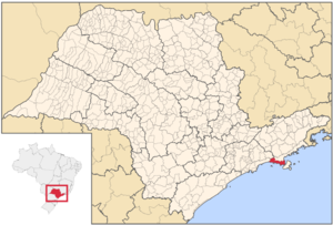
map_caption = Location in the state of São Paulo andBrazil
subdivision_type = Country
subdivision_name =Brazil
subdivision_type1 = Region
subdivision_name1 = Southeast
subdivision_type2 = State
subdivision_name2 = São Paulo
leader_title =Mayor
leader_name = Juan Manoel Pons Garcia (PPS)
established_title = Settled
established_date =1636
area_magnitude =
area_total_km2 = 403,336
area_total_sq_mi = 108.2
area_land_km2 =
area_land_sq_mi =
area_water_km2 =
area_water_sq_mi =
area_water_percent =
area_urban_km2 =
area_urban_sq_mi =
area_metro_km2 = 2373
area_metro_sq_mi = 916.2
population_as_of = 2006
population_note =
population_total = 75,886
population_footnotes = [http://www.ibge.gov.br/home/estatistica/populacao/estimativa2006/POP_2006_DOU.pdf]
population_density_km2 = 188.1
population_density_sq_mi =
population_metro =
population_density_metro_km2 =
population_density_metro_sq_mi =
population_urban =
timezone =UTC-3
utc_offset = -3
timezone_DST =UTC-2
utc_offset_DST = -2
latd= 23|latm= 50|lats= 46|latNS=S
longd= 46|longm= 37|longs= 47|longEW=W
elevation_m =
elevation_ft =
postal_code_type =
postal_code =
website = [http://www.saosebastiao.sp.gov.br Prefeitura Municipal de São Sebastião]
footnotes =São Sebastião (Portuguese for
Saint Sebastian ) is aBrazil ian city, located on the southeast coast of Brazil, in the state of São Paulo. The population in2003 is 65,477, its density is 162.47/km² and the area is 403 km². TheTropic of Capricorn lies 25 km north. The municipality existed since1636 and formed a part of the old hereditary captaincy of Santo Amaro. The urban area is on the Atlantic coast, much of the area are heavily forested to the north and makes upSerra do Mar with no accessible roads to the north.The island of São Sebastião which is part of the municipality of
Ilhabela is located in the west coast of São Sebastião. The coast is located in the commercial centre of the city. Between the city and the island is the São Sebastião canal with 30kilometre s in length, and variable width (7km being the shortest crossing).The canal by its port are a refinery that is owned by
Transpetro , a subsidiary ofPetrobrás , apetroleum company, that makes up 80% of the Brazilian combustible exports.The city is famous for its beaches and tourism. Beaches include (from north to south) Preta, Grande (or dos Trabalhadores), Pitangueiras, Cabelo Gordo,
Barequeçaba , Guaecá, Brava de Guaecá, Toque-Toque Grande, Toque-Toque Pequeno, Calhetas, Santiago, Paúba, Maresias, Brava de Maresias, Boiçucanga, Camburi, Baleia, Barra do Sahy, Conchas, Juquehy, Barra do Una, Juréia, e Boracéia. Near the boundary with Bertioga there is a small Amerindian village.ister City
São Sebastião has one sister city designed by Sister Cities International:
*flagicon|United States
Fort Lauderdale, Florida References
External links
* [http://www.transpetro.com.br Transpetro] (in English, Portuguese and Spanish)
* http://www.saosebastiao.sp.gov.br
* [http://www.citybrazil.com.br/SP/saosebastiao citybrazil.com.br]Geographic Location
Centre = São Sebastião
North =Caraguatatuba
Northeast =Salesópolis
East =Ilhabela
Southeast =
South =Atlantic Ocean
Southwest =
West =Bertioga
Northwest =Salesópolis

Wikimedia Foundation. 2010.