- Marabá Airport
-
Marabá Airport
Aeroporto de Marabá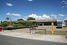
IATA: MAB – ICAO: SBMA Summary Airport type Public Operator Infraero Serves Marabá Elevation AMSL 109 m / 357 ft Coordinates 05°22′07″S 049°08′17″W / 5.36861°S 49.13806°WCoordinates: 05°22′07″S 049°08′17″W / 5.36861°S 49.13806°W Website Map Location in Brazil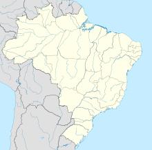
 MAB
MABRunways Direction Length Surface m ft 07/25 2,000 6,562 Asphalt Statistics (2010) Passengers 242,415 Aircraft Operations 11,708 Metric tonnes of cargo 1,725 Statistics: Infraero [1]
Sources: Airport Website[2]Marabá Airport (IATA: MAB, ICAO: SBMA) is the airport serving Marabá, Brazil.
It is operated by Infraero.
Contents
History
The airport was inaugurated on May 20, 1978.
Airlines and destinations
Airlines Destinations Gol Airlines Belém-Val de Cães, Brasília SETE Linhas Aéreas Altamira, Araguaína, Belém-Val de Cães, Carajás, Conceição do Araguaia, Goiânia, Ourilândia do Norte, Palmas, Redenção TAM Airlines Belém-Val de Cães, Brasília TRIP Linhas Aéreas Belém-Val de Cães, Carajás Accidents and incidents
- 3 September 1989: a Varig Boeing 737-241 registration PP-VMK operating flight 254 flying from São Paulo-Guarulhos to Belém-Val de Cães with intermediate stops, crashed near São José do Xingu while on the last leg of the flight between Marabá and Belém due to a pilot navigational error, which led to fuel exhaustion and a subsequent belly landing into the jungle, 450 miles (724 km) southwest of Marabá. Out of 54 occupants, there were 13 fatalities, all of them passengers. The survivors were discovered two days later.[3]
- 14 February 1997: a Varig Boeing 737-241 registration PP-CJO operating flight 265, flying from Marabá to Carajás while on touch-down procedures at Carajás during a thunderstorm, had its right main gear collapsed rearwards causing the aircraft to veer off the right of the runway. The aircraft ended in the forest. One crew member died.[4]
Access
The airport is located 5 km (3 mi) from downtown Marabá.
See also
References
- ^ Infraero Statistics for the Airport
- ^ Airport Official Website
- ^ "Accident description PP-VMK". Aviation Safety Network. http://aviation-safety.net/database/record.php?id=19890903-0. Retrieved 25 June 2011.
- ^ "Accident description PP-CJO". Aviation Safety Network. http://aviation-safety.net/database/record.php?id=19970214-0. Retrieved 17 June 2011.
External links
- Airport information for SBMA at World Aero Data. Data current as of October 2006.Source: DAFIF.
- Airport information for SBMA at Great Circle Mapper. Source: DAFIF (effective Oct. 2006).
- Current weather for SBMA at NOAA/NWS
- Accident history for MAB at Aviation Safety Network
- Marabá Airport Photo Archive at airliners.net
Lists of airports By IATA code - A
- B
- C
- D
- E
- F
- G
- H
- I
- J
- K
- L
- M
- N
- O
- P
- Q
- R
- S
- T
- U
- V
- W
- X
- Y
- Z
By ICAO code - A
- B
- C
- D
- E
- F
- G
- H
- I
- J
- K
- L
- M
- N
- O
- P
- Q
- R
- S
- T
- U
- V
- W
- X
- Y
- Z
By traffic Other lists - Airports by country
- Airport eponyms
- Airline destinations
- Military installations
Lists relating to aviation General Aircraft (manufacturers) · Aircraft engines (manufacturers) · Airlines (defunct) · Airports · Civil authorities · Museums · Registration prefixes · Rotorcraft (manufacturers) · TimelineMilitary Accidents/incidents Records  Brazil
History First inhabitants · Colonization · Empire · Old Republic · Vargas Era · Second Republic · Military rule · ContemporaryGeography Regions · States · Mesoregions · Microregions · Municipalities · Islands · Coastline · Climate · Environment · Extreme points · Protected areas · CapitalsGovernment Constitution · Federal government · President · National Congress · Foreign relations · Law · Law enforcement · MilitaryPolitics Economy Society Demographics · People · Languages · Religion · Immigration · Education · Health · Crime · Social issues · Largest cities · ApartheidCulture


Wikimedia Foundation. 2010.