- Dutch Mills, Arkansas
-
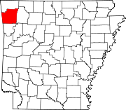
Dutch Mills, Arkansas — Unincorporated community — Turn off to Dutch Mills on AR 59 Dutch Mill's position in Arkansas. Coordinates: 35°52′32″N 94°29′30″W / 35.87556°N 94.49167°WCoordinates: 35°52′32″N 94°29′30″W / 35.87556°N 94.49167°W Country  United States
State  Arkansas
County Washington Township Dutch Mills First settled early 1850s Hermannsburg post office established September 1853 Elevation 313 m (1,027 ft) Time zone Central (CST) (UTC-6) – Summer (DST) CDT (UTC-5) Zip code 72744 Area code(s) 479 GNIS feature ID 71480 U.S. Geological Survey Geographic Names Information System: Dutch Mills, Arkansas Dutch Mills is an unincorporated community in Dutch Mills Township, Washington County, Arkansas, United States. Dutch Mills is on Arkansas Highway 59 about 6 miles (9.7 km) south of U.S. Route 62 and 1 mile (1.6 km) east of the Oklahoma border.
Since Dutch Mills is a small rural community, it receives mail delivery from Lincoln (ZIP code 72744). The population of the Lincoln ZCTA was 4,571[1] at the 2000 census. It is part of the Fayetteville–Springdale–Rogers, AR-MO Metropolitan Statistical Area.
Contents
History
Dutch Mills was originally called Hermannsburg, named after its first documented settler, Johann H. Hermann, a German immigrant and former student at the University of Heidelberg. In the early 1850s, Johann Hermann and his brother, Karl F. Hermann acquired the property of the town, built a mill, laid out the lots, and acquired the rights to a United States post office. The brothers operated the mill, a small store, and both served as Postmaster (Johann in 1856 and Karl in 1859). Multiple German families moved there, following the Hermanns.[2]
Hermannsburg was located at a dangerous crossroads between The North and The South during the American Civil War. Bushwackers from both sides of the conflict regularly pillaged the town and conditions worsened after the Battle of Wilson's Creek. Renegade Missouri Governor Claiborne Jackson and his Confederate militia commandeered the Hermann home in Hermannsburg for the night while on their flight to Texas. Because many German immigrants sided with the Union cause, Southern bushwackers would often target them for robbery and even murder. In December 1862, the last 19 German immigrants who remained in the town, including the Hermann brothers and their families, fled Hermannsburg under the cover of night for the safety of the larger German community in St. Louis.[3]
After the Civil War, the name of Hermannsburg was changed to Dutch Mills. The name change was likely intended as subtle insult, or perhaps a statement of indifference, by the English descended residents who didn't care to differentiate between the Germans and the Dutch.[4]
Buried treasure story
Before the Hermann brothers fled the town during the Civil War, they buried four gallon sized jars of gold coins for hiding because of the liklihood of being robbed while traveling. After the end of the war, Karl Hermann returned to Hermannsburg to retrieve his gold, but the landscape had changed due to the effects of war, and he was limited to having to secretely dig at night for his own security. He was only able to find two of his four jars which he brought back to St. Louis. The other two jars are unaccounted for, and may still be buried somewhere in Dutch Mills today.[5]
Education
Dutch Mills is located within the Lincoln Consolidated Public School District.
Notes
- ^ U.S. Census Bureau Fact Finder Fact Sheet for Zip Code Tabulation Area 72744
- ^ Lemke, W.J. The Hermanns of Old Hermannsburg. Washington County Historical Society, 1965.
- ^ Lemke, W.J. The Hermanns of Old Hermannsburg. Washington County Historical Society, 1965.
- ^ Lemke, W.J. The Hermanns of Old Hermannsburg. Washington County Historical Society, 1965.
- ^ Lemke, W.J. The Hermanns of Old Hermannsburg. Washington County Historical Society, 1965.
Municipalities and communities of Washington County, Arkansas Cities Elkins | Elm Springs‡ | Farmington | Fayetteville | Greenland | Johnson | Lincoln | Prairie Grove | Springdale‡ | Tontitown | West Fork | Winslow
Town Townships Boston | Brush Creek | Cane Hill | Center | Cove Creek | Crawford | Durham | Dutch Mills | Elkins | Elm Springs | Farmington | Fayetteville | Goshen | Greenland | Harmon | Illinois | Johnson | Lee's Creek | Lincoln | Litteral | Marrs Hill | Morrow | Prairie | Prairie Grove | Reed | Rhea's Mill | Richland | Springdale | Starr Hill | Tontitown | Valley | Vineyard | Wedington | West Fork | White River | Winslow | Wyman
Unincorporated
communitiesAppleby | Arnett | Baldwin | Banyard | Beav-O-Rama | Black Oak | Blackburn | Blue Springs Village | Brentwood | Canehill | Cincinnati | Clyde | Durham | Dutch Mills | Evansville | Fayette Junction | Floss | Gulley | Habberton | Harmon | Harris | Hazel Velley | Hicks | Hogeye | Hubbard | Mayfield | McNair | Morrow | Mount Olive | Oak Grove | Odell | Onda | Pilgrim's Rest | Pitkin Corner | Rhea | Rochelle Riviera | Savoy | Shady Grove | Skylight | Sonora | Spring Valley | Starks | Steele | Strain | Strickler | Sulphur City | Summers | Sunset | Suttle | Tolu | Tuttle | Viney Grove | Walnut Grove | War Eagle Cove | Wedington | Wedington Woods | Wheeler | White Rock | Woolsey | Wyman | Wyola
Ghost towns Barbara | Blewford | Carter | Cross Roads | Jabur | McGuire | Porter's Store | Rickert | Rucker's Grove | Sexton | Summit | Sydenham
Footnotes ‡This populated place also has portions in an adjacent county or counties
Categories:- Populated places in Washington County, Arkansas
- Fayetteville–Springdale–Rogers metropolitan area
- Unincorporated communities in Arkansas
- Populated places established in 1853
Wikimedia Foundation. 2010.


