- Cove Creek Township, Washington County, Arkansas
-
Township of Cove Creek — Township — Location of Cove Creek Township in Washington County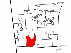 Location of Washington County in Arkansas
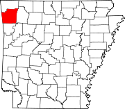
Coordinates: 35°49′00″N 94°18′00″W / 35.8166667°N 94.3°WCoordinates: 35°49′00″N 94°18′00″W / 35.8166667°N 94.3°W Country  United States
State  Arkansas
County Washington Established 1842[1] Area – Total 45.9 sq mi (118.9 km2) – Land 45.9 sq mi (118.9 km2) – Water 0.0 sq mi (0 km2) 0% Elevation 1,781 ft (543 m) Population (2000)[2] – Total 683 – Density 15/sq mi (5.8/km2) Time zone CST (UTC-6) – Summer (DST) CDT (UTC-5) Area code(s) 479 GNIS feature ID 69783 U.S. Geological Survey Geographic Names Information System: Cove Creek Township, Washington County, Arkansas Township of Cove Creek is one of thirty-seven townships in Washington County, Arkansas, USA.[2] As of the 2000 census, its total population was 683. Part of Devil's Den State Park is located in Cove Creek Township.
Contents
Geography
According to the United States Census Bureau, Cove Creek Township covers an area of 45.9 square miles (119 km2); all land.[2] Cove Creek Township was created in 1842 from parts of Mountain Township. It gave part to Lee's Creek Township in 1880.[1]
Cities, towns, villages
- Strickler
Cemeteries
The township contains Dunkard, Liberty, Morrow, and Scott Cemeteries.
Major routes
References
- United States Census Bureau 2008 TIGER/Line Shapefiles
- United States Board on Geographic Names (GNIS)
- United States National Atlas
External links

Cane Hill Township Valley Township West Fork Township Boston Township 
Lee's Creek Township  Cove Creek Township

Barker Township, Crawford County Cove City Township, Crawford County Upper Township, Crawford County Municipalities and communities of Washington County, Arkansas Cities Elkins | Elm Springs‡ | Farmington | Fayetteville | Greenland | Johnson | Lincoln | Prairie Grove | Springdale‡ | Tontitown | West Fork | Winslow
Town Townships Boston | Brush Creek | Cane Hill | Center | Cove Creek | Crawford | Durham | Dutch Mills | Elkins | Elm Springs | Farmington | Fayetteville | Goshen | Greenland | Harmon | Illinois | Johnson | Lee's Creek | Lincoln | Litteral | Marrs Hill | Morrow | Prairie | Prairie Grove | Reed | Rhea's Mill | Richland | Springdale | Starr Hill | Tontitown | Valley | Vineyard | Wedington | West Fork | White River | Winslow | Wyman
Unincorporated
communitiesAppleby | Arnett | Baldwin | Banyard | Beav-O-Rama | Black Oak | Blackburn | Blue Springs Village | Brentwood | Canehill | Cincinnati | Clyde | Durham | Dutch Mills | Evansville | Fayette Junction | Floss | Gulley | Habberton | Harmon | Harris | Hazel Velley | Hicks | Hogeye | Hubbard | Mayfield | McNair | Morrow | Mount Olive | Oak Grove | Odell | Onda | Pilgrim's Rest | Pitkin Corner | Rhea | Rochelle Riviera | Savoy | Shady Grove | Skylight | Sonora | Spring Valley | Starks | Steele | Strain | Strickler | Sulphur City | Summers | Sunset | Suttle | Tolu | Tuttle | Viney Grove | Walnut Grove | War Eagle Cove | Wedington | Wedington Woods | Wheeler | White Rock | Woolsey | Wyman | Wyola
Ghost towns Barbara | Blewford | Carter | Cross Roads | Jabur | McGuire | Porter's Store | Rickert | Rucker's Grove | Sexton | Summit | Sydenham
Footnotes ‡This populated place also has portions in an adjacent county or counties
Categories:- Townships in Washington County, Arkansas
- Populated places established in 1842


Wikimedia Foundation. 2010.