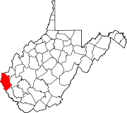
- Cove Gap, West Virginia
-
Cove Gap, West Virginia — Unincorporated community — Coordinates: 38°05′44″N 82°15′16″W / 38.09556°N 82.25444°WCoordinates: 38°05′44″N 82°15′16″W / 38.09556°N 82.25444°W Country United States State West Virginia County Wayne Elevation 873 ft (266 m) Time zone Eastern (EST) (UTC-5) - Summer (DST) EDT (UTC-4) Area code(s) 304 & 681 GNIS feature ID 1537725[1] Cove Gap is an unincorporated community in Wayne County, West Virginia, United States. Cove Gap is 13.5 miles (21.7 km) southeast of Wayne.
References
- ^ "US Board on Geographic Names". United States Geological Survey. 2007-10-25. http://geonames.usgs.gov. Retrieved 2008-01-31.
Municipalities and communities of Wayne County, West Virginia County seat: Wayne Cities Ceredo | Huntington‡ | Kenova
Towns CDPs Unincorporated
communitiesArdel | Armilda | Bethesda | Booton | Bowen | Brabant | Buffalo Creek | Centerville | Coleman | Cove Gap | Crockett | Cyrus | Dickson | Doane | Dunlow | East Lynn | Echo | Effie | Elmwood | Ferguson | Fleming | Genoa | Gilkerson | Girard | Glenhayes | Grandview Gardens | Hidden Valley | Hubbardstown | Kiahsville | Mineral Springs | Missouri Branch | Neal | Nestlow | Oakview Heights | Quaker | Radnor | Saltpetre | Shoals | Sidney | Stepptown | Stiltner | Stonecoal | Sweet Run | Tripp | Webb | Westmoreland | Wilsondale | Winslow
Footnotes ‡This populated place also has portions in an adjacent county or counties
Categories:- Populated places in Wayne County, West Virginia
- Unincorporated communities in West Virginia
- Metro Valley geography stubs
Wikimedia Foundation. 2010.


