- Missouri Branch, West Virginia
-
Missouri Branch, West Virginia — Unincorporated community — 
 Missouri Branch, West Virginia
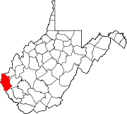
Coordinates: 37°59′54″N 82°24′23″W / 37.99833°N 82.40639°WCoordinates: 37°59′54″N 82°24′23″W / 37.99833°N 82.40639°W Country United States State West Virginia County Wayne Elevation 705 ft (215 m) Time zone Eastern (EST) (UTC-5) - Summer (DST) EDT (UTC-4) Area code(s) 304 & 681 GNIS feature ID 1555139[1] Missouri Branch is an unincorporated community in Wayne County, West Virginia, United States. Missouri Branch is located on West Virginia Route 152 13 miles (21 km) southeast of Fort Gay.
References
Municipalities and communities of Wayne County, West Virginia County seat: Wayne Cities Ceredo | Huntington‡ | Kenova
Towns CDPs Unincorporated
communitiesArdel | Armilda | Bethesda | Booton | Bowen | Brabant | Buffalo Creek | Centerville | Coleman | Cove Gap | Crockett | Cyrus | Dickson | Doane | Dunlow | East Lynn | Echo | Effie | Elmwood | Ferguson | Fleming | Genoa | Gilkerson | Girard | Glenhayes | Grandview Gardens | Hidden Valley | Hubbardstown | Kiahsville | Mineral Springs | Missouri Branch | Neal | Nestlow | Oakview Heights | Quaker | Radnor | Saltpetre | Shoals | Sidney | Stepptown | Stiltner | Stonecoal | Sweet Run | Tripp | Webb | Westmoreland | Wilsondale | Winslow
Footnotes ‡This populated place also has portions in an adjacent county or counties
Categories:- Populated places in Wayne County, West Virginia
- Unincorporated communities in West Virginia
- Metro Valley geography stubs


Wikimedia Foundation. 2010.