- Morrow Township, Washington County, Arkansas
-
Township of Morrow — Township — Location of Morrow Township in Washington County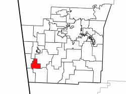 Location of Washington County in Arkansas
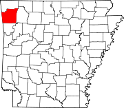
Coordinates: 35°52′15″N 94°26′1″W / 35.87083°N 94.43361°WCoordinates: 35°52′15″N 94°26′1″W / 35.87083°N 94.43361°W Country  United States
State  Arkansas
County Washington Established Area - Total 11.3 sq mi (29.3 km2) - Land 11.3 sq mi (29.3 km2) - Water 0.0 sq mi (0 km2) 0% Elevation 1,142 ft (348 m) Population (2000) - Total 459 - Density 40/sq mi (15.4/km2) Time zone CST (UTC-6) - Summer (DST) CDT (UTC-5) Area code(s) 479 GNIS feature ID 69796 U.S. Geological Survey Geographic Names Information System: Morrow Township, Washington County, Arkansas Morrow Township is one of thirty-seven townships in Washington County, Arkansas, USA.[1] As of the 2000 census, its total population was 898.
Contents
Geography
According to the United States Census Bureau, Morrow Township covers an area of 11.3 square miles (29 km2); all land.[1]
Cities, towns, villages
Cemeteries
The township contains Bethesda Cemetery, Bethlehem Cemetery, Drake Cemetery, Edmiston Cemetery, and English Cemetery.
Major routes
 Arkansas Highway 45
See also
- Twin Bridges Historic District
References
- United States Census Bureau 2008 TIGER/Line Shapefiles
- United States Board on Geographic Names (GNIS)
- United States National Atlas
- ^ a b "Township of Morrow, Washington County, Arkansas". U.S. Census Bureau.. http://www.city-data.com/township/Morrow-Washington-AR.html. Retrieved 09-16-2011.
External links

Starr Hill Township Cane Hill Township Dutch Mills Township 
Center Township  Morrow Township

Vineyard Township Boston Township Municipalities and communities of Washington County, Arkansas Cities Elkins | Elm Springs‡ | Farmington | Fayetteville | Greenland | Johnson | Lincoln | Prairie Grove | Springdale‡ | Tontitown | West Fork | Winslow
Town Townships Boston | Brush Creek | Cane Hill | Center | Cove Creek | Crawford | Durham | Dutch Mills | Elkins | Elm Springs | Farmington | Fayetteville | Goshen | Greenland | Harmon | Illinois | Johnson | Lee's Creek | Lincoln | Litteral | Marrs Hill | Morrow | Prairie | Prairie Grove | Reed | Rhea's Mill | Richland | Springdale | Starr Hill | Tontitown | Valley | Vineyard | Wedington | West Fork | White River | Winslow | Wyman
Unincorporated
communitiesAppleby | Arnett | Baldwin | Banyard | Beav-O-Rama | Black Oak | Blackburn | Blue Springs Village | Brentwood | Canehill | Cincinnati | Clyde | Durham | Dutch Mills | Evansville | Fayette Junction | Floss | Gulley | Habberton | Harmon | Harris | Hazel Velley | Hicks | Hogeye | Hubbard | Mayfield | McNair | Morrow | Mount Olive | Oak Grove | Odell | Onda | Pilgrim's Rest | Pitkin Corner | Rhea | Rochelle Riviera | Savoy | Shady Grove | Skylight | Sonora | Spring Valley | Starks | Steele | Strain | Strickler | Sulphur City | Summers | Sunset | Suttle | Tolu | Tuttle | Viney Grove | Walnut Grove | War Eagle Cove | Wedington | Wedington Woods | Wheeler | White Rock | Woolsey | Wyman | Wyola
Ghost towns Barbara | Blewford | Carter | Cross Roads | Jabur | McGuire | Porter's Store | Rickert | Rucker's Grove | Sexton | Summit | Sydenham
Footnotes ‡This populated place also has portions in an adjacent county or counties
Categories:- Townships in Washington County, Arkansas
- Populated places established in 1850


Wikimedia Foundation. 2010.