- Kearny Mesa, San Diego
-
Kearny Mesa — Community of San Diego — Convoy Street in Kearny Mesa Location within Northwestern San Diego
 Kearny Mesa
Coordinates: 32°49′30″N 117°08′21″W / 32.825°N 117.139167°W Country United States State California County County of San Diego City City of San Diego Kearny Mesa is a community in the eastern part of San Diego, California. It is located in the area of the city that is bounded by State Route 52 to the north, Interstate 805 to the west, Aero Drive to the South, and Interstate 15 to the east. Adjacent communities include Serra Mesa, Clairemont and Tierrasanta.
Kearny Mesa has a population of 2,837.[1]
Contents
History
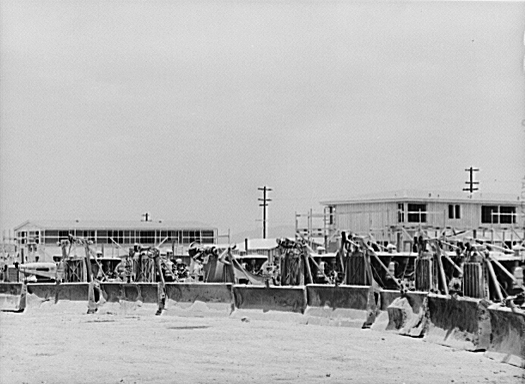
 Defense worker housing under construction at Kearny Mesa in 1941. Photo by Russell Lee.
Kearny Mesa is named for the former Camp Kearny, a U.S. military base which operated in the area from 1917 to 1946 and eventually became Marine Corps Air Station Miramar. Camp Kearny in turn was named for Brigadier General Stephen W. Kearny, a leader in the Mexican-American War who also served as a military governor of California.[2] While "Kearny," the person, was pronounced Car-nee," San Diegans use the "Cur-nee" pronunciation.
The urbanization of Kearny Mesa began in 1937 with Gibbs Airfield, now the small airfield Montgomery Field. In 1948, the City of San Diego acquired the airfield and 1,400 acres (6 km2) of surrounding property, intending it as a possible replacement site for San Diego International Airport. However, airspace conflicts with MCAS Miramar (at that time NAS Miramar) made the proposed airport infeasible. Montgomery Field was restricted to small aircraft, and the surplus land was converted to an industrial park.
Beginning in 1955 with General Dynamics, numerous aerospace, electronic, and other industrial and office firms located in the area. There was also commercial development, particularly west of State Route 163.
Geography
As implied by the name "mesa", the area is mostly flat.
Montgomery Field is a local municipal airport.[3] The community is adjacent to Marine Corps Air Station Miramar.
The area is predominantly industrial and commercial, but there are several residential developments in the community, among them Stonecrest, Kearny Lodge, and Royal Highlands. The former General Dynamics site is now a mixed-use development known as Spectrum. Several city and county facilities are located in or adjacent to the area, including the Miramar Landfill.[citation needed]
Kearny Mesa is located between the communities of Clairemont to the west, Tierrasanta to the east, Miramar/Mira Mesa to the north, and Linda Vista/Serra Mesa to the south. The area is bordered by the major highways of San Diego. Kearny Mesa is triangular with its base Highway 52 bordering the top side on the north and the two other sides being represented by Interstate 805 to the west and Highway 163 to the east and extending southward.[citation needed]
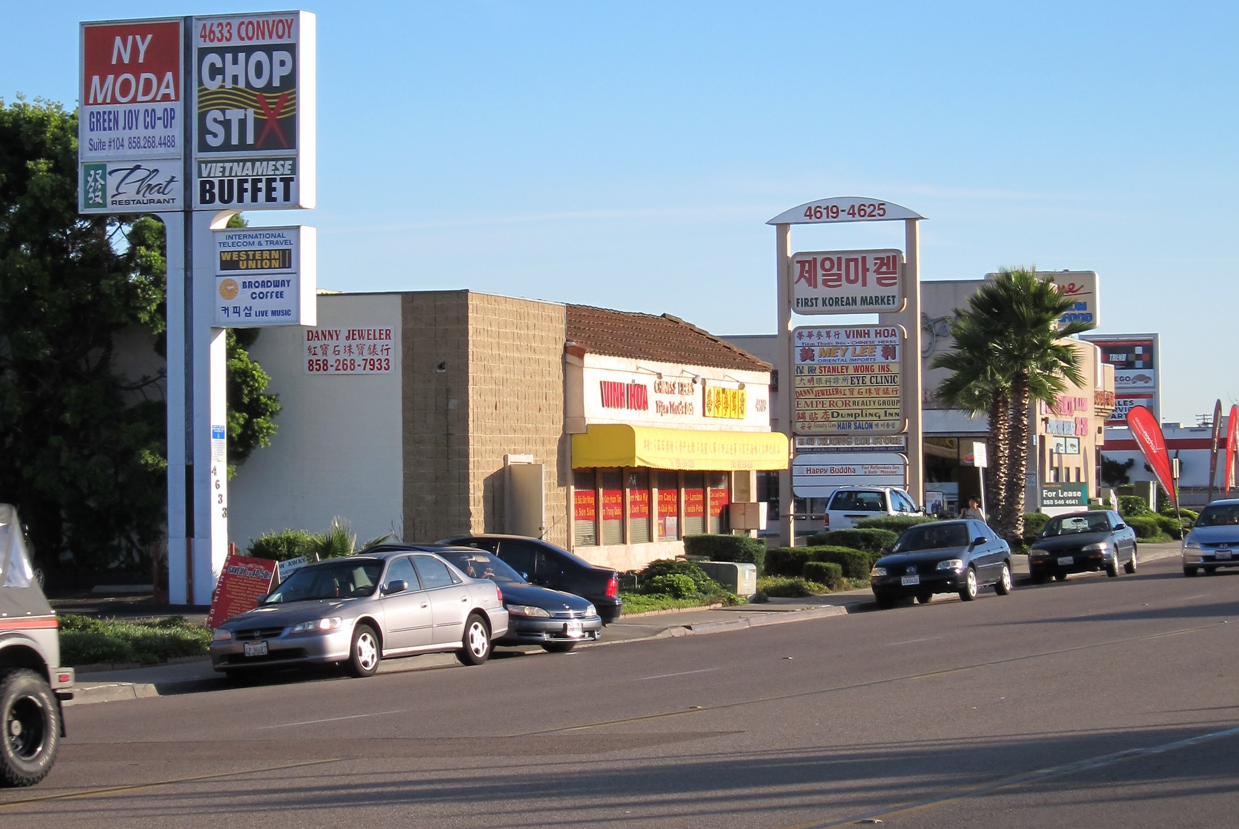
Convoy Street
Convoy is unique in the number of diverse businesses owned and representative of different Asian cultures such as Korean, Japanese, Vietnamese, Chinese, and Thai eating establishments. Restaurants offer items such as boba milk teas, BBQ, seafood, pho, and ramen. There are markets that cater to different cultures including 99 Ranch Market on the north end (along Clairemont Mesa Boulevard), Zion Market and Mitsuwa Marketplace in the east/central areas (near Balboa Ave, along the Route 163 side), or the Nijiya market on the south end (just before it crosses the I-805 overpass past Aero Drive).[citation needed]
Government
The area is part of City Council District 6 and is represented by Councilwoman Lorie Zapf.[4]
The original 1977 Serra Mesa Community Plan included Kearny Mesa. It was replaced by the 1992 Kearny Mesa Community Plan which applies just to Kearny Mesa. The Montgomery Field Master Plan also contains land use policies for areas adjacent to the airport.
Community groups
The Kearny Mesa Planning Group advises the city on land use and other issues.
References
- ^ Onboard Informatics. "Schools and Demographics in Kearny Mesa." Onboard Informatics, 2009. Web. 29 March 2010.
- ^ Fetzer, Leland, San Diego County Place Names A to Z, page 73, Sunbelt Publications, Inc, 2005, ISBN 978-0-932653-73-4
- ^ [1]
- ^ District 6 website
- "San Diego Community Profile: Kearny Mesa". The City of San Diego. http://www.sandiego.gov/planning/community/profiles/kearnymesa/index.shtml. Retrieved 2007-01-29.
External links
- Kearny Mesa Planning Group
- Kearny Mesa Neighborhood Link
- State of Serra Mesa and Kearny Mesa, 2009, by Councilwoman Donna Frye
Neighborhoods of San Diego Northern Bay Ho · Bay Park · Carmel Valley · Clairemont · Del Mar Heights · Del Mar Mesa · La Jolla · La Jolla Village · Mission Beach · North City · Pacific Beach · Pacific Highlands Ranch · Torrey Hills · Torrey Pines · University City · Village of La JollaNortheastern Black Mountain Ranch · Carmel Mountain Ranch · Mira Mesa · Miramar · Rancho Bernardo · Rancho Encantada · Rancho Peñasquitos · Sabre Springs · San Pasqual Valley · Scripps Ranch · Sorrento Valley · Sorrento Mesa · Torrey HighlandsEastern Birdland · Kearny Mesa · Mission Valley East · Navajo (Allied Gardens · Del Cerro · Grantville · San Carlos) · Serra Mesa · TierrasantaWestern Burlingame · Hillcrest · Linda Vista · Midtown · Mission Hills · Mission Valley West · Morena · North Park · Ocean Beach · Old Town · Point Loma (La Playa · Liberty Station · Loma Portal · Midway · Point Loma Heights · Roseville-Fleetridge · Sunset Cliffs · Wooded Area) · University HeightsCentral Downtown (Columbia · Core · Cortez Hill · East Village · Gaslamp Quarter · Harborview · Little Italy · Marina) · Balboa Park · Bankers Hill · Barrio Logan · Golden Hill · Grant Hill · Logan Heights · Middletown · Sherman Heights · South Park · StocktonMid-City Adams North · Azalea/Hollywood Park · Castle · Cherokee Point · Chollas Creek · City Heights · Colina del Sol · College Area · Corridor · Darnall · El Cerrito · Fairmont Park · Fox Canyon · Gateway · Islenair · Kensington · Normal Heights · Oak Park · Ridgeview · Redwood Village · Rolando · Swan Canyon · Talmadge · Teralta · WebsterSoutheastern Alta Vista · Bay Terraces · Broadway Heights · Chollas View · Emerald Hills · Encanto · Jamacha-Lomita · Lincoln Park · Mountain View · Mount Hope · Paradise Hills · Shelltown · Skyline · Southcrest · Valencia ParkSouthern Border · Egger Highlands · Nestor · Ocean View Hills · Otay Mesa · Otay Mesa West · Palm City · San Ysidro · Tijuana River ValleyCategories:- Neighborhoods in San Diego, California
Wikimedia Foundation. 2010.