- California State Route 52
Infobox road
state=CA
type=SR
route=52
section=352
maint=Caltrans 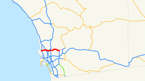
length_mi=15
length_round=0
length_ref=Fact|date=January 2008
established=
direction_a=West
terminus_a=jct|state=CA|I|5 in San Diego
direction_b=East
terminus_b=jct|state=CA|SR|125 in Santee
previous_type=SR
previous_route=51
next_type=SR
next_route=53State Route 52 is a California State Highway in San Diego County, that extends from La Jolla Parkway at Interstate 5 in La Jolla to Route 125 in Santee. Route 52 is a
freeway for its entire length.Highway 52 successfully relieved a parallel East-West route Interstate 8, five miles (8 km) to the south, of some congestion. However, it became overwhelmed as soon as construction to Mission Gorge Rd in December, 1993 was finished, as it was the only freeway connecting directly with the suburban City of Santee. Prior to 1993, Route 52 was known as the Soledad Highway, connecting between Interstate 5/Ardath Road (now called La Jolla Parkway) and 805, in San Clemente Canyon.
Near its center, where it meets with Interstate 15 and Route 163, is one of the worst traffic bottlenecks in the county during morning rush-hour. This is where three Westbound lanes narrow to two. To lessen the bottleneck a construction crew in March, 2007 is currently widening this 2 1/2-mile stretch to three lanes in both directions.
In 2006, MTS, in cooperation with
SANDAG ,Caltrans and theCalifornia Highway Patrol , began a pilot program to operate transit buses on the freeway shoulders of Route 52, between Kearny Villa Road and 805. During rush hour times, buses could use the freeway shoulders as a transit-only lane to bypass slow traffic on the main lanes. This included the use of the freeway shoulders on the ramp connectors between 52 and 805.Construction from its present terminus eastward to Route 67 began in fall of 2007 [http://www.dot.ca.gov/dist11/facts/52.pdf California Department of Transportation, State Route 52 (SR-125 to SR-67)] ] .
Two reversible HOV traffic lanes are scheduled to be built around 2012.
This route is part of the
California Freeway and Expressway System [http://www.leginfo.ca.gov/cgi-bin/displaycode?section=shc&group=00001-01000&file=250-257 CA Codes (shc:250-257)] ] and is eligible for the State Scenic Highway System [http://www.leginfo.ca.gov/cgi-bin/displaycode?section=shc&group=00001-01000&file=260-284 CA Codes (shc:260-284)] ] .Exit list
:"Note: Except where prefixed with a letter,
postmile s were measured in 1964, based on the alignment as it existed at that time, and do not necessarily reflect current mileage."The entire route is in San Diego County.References
External links
* [http://www.westcoastroads.com/california/ca-052.html California @ WestCoastRoads.com - State Route 52]
* [http://www.dot.ca.gov/hq/roadinfo/sr52 Caltrans: Route 52 highway conditions]
* [http://www.cahighways.org/049-056.html#052 California Highways: SR 52]
* [http://www.dot.ca.gov/dist11/facts/52.pdf Route 52 Fact Sheet]

Wikimedia Foundation. 2010.