- Cortez Hill, San Diego
-
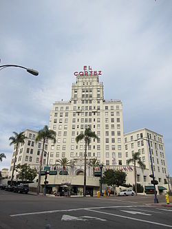 The El Cortez Apartment Hotel at the corner of Ash Street and Seventh Street
Cortez Hill is a neighborhood located in north-east Downtown San Diego, California.
Contents
Geography
Cortez Hill is located south of Bankers' Hill, north of the Core District, east of Little Italy and west by Balboa Park. This district is bordered by Interstate 5 to the north, Ash Street/A Street to the south, 11th Avenue/SR 163 to the east and Front Street to the west.[1]
History
Named after the historic El Cortez Hotel, this district is one of San Diego's oldest residential neighborhoods. North of downtown's Core and south of I-5 between Tenth Avenue and Union Street, the 111- acre Cortez Hill is two neighborhoods in one. East of Sixth Avenue rises downtown's highest land mass, the hill dominated by the El Cortez Condominium (formerly El Cortez Hotel). West of Sixth Avenue the flatter area is known as Cortez West. The hill has drawn residents for over a century, and some of the original Victorian style dwellings of the first settlers are still present.
In 1992, the Redevelopment Agency envisioned reviving this district by further developing the hill for residential use, and encouraging a mix of residential and commercial infill. Schools, churches and a pedestrian-friendly environment now characterize the western portion of Cortez Hill. Commercial shops and sidewalk cafes line Fifth and Sixth Avenues, and Ash Street provides a gateway to the waterfront. As the highest land mass in the Centre City Community Planning area, Cortez Hill boasts views of urban San Diego, Balboa Park, the bay and Pacific Ocean. New developments include 6,000 square feet (600 m2) of retail space, 758 residential units and the Cortez Hill Neighborhood Park/Tweet Street. Also in place is a plan to reduce non-resident parking.
External links
References
- ^ Neighborhood Map. Centre City Development Corporation. Retrieved on 2007-09-18.
Neighborhoods of San Diego Northern Bay Ho · Bay Park · Carmel Valley · Clairemont · Del Mar Heights · Del Mar Mesa · La Jolla · La Jolla Village · Mission Beach · North City · Pacific Beach · Pacific Highlands Ranch · Torrey Hills · Torrey Pines · University City · Village of La JollaNortheastern Black Mountain Ranch · Carmel Mountain Ranch · Mira Mesa · Miramar · Rancho Bernardo · Rancho Encantada · Rancho Peñasquitos · Sabre Springs · San Pasqual Valley · Scripps Ranch · Sorrento Valley · Sorrento Mesa · Torrey HighlandsEastern Birdland · Kearny Mesa · Mission Valley East · Navajo (Allied Gardens · Del Cerro · Grantville · San Carlos) · Serra Mesa · TierrasantaWestern Burlingame · Hillcrest · Linda Vista · Midtown · Mission Hills · Mission Valley West · Morena · North Park · Ocean Beach · Old Town · Point Loma (La Playa · Liberty Station · Loma Portal · Midway · Point Loma Heights · Roseville-Fleetridge · Sunset Cliffs · Wooded Area) · University HeightsCentral Downtown (Columbia · Core · Cortez Hill · East Village · Gaslamp Quarter · Harborview · Little Italy · Marina) · Balboa Park · Bankers Hill · Barrio Logan · Golden Hill · Grant Hill · Logan Heights · Middletown · Sherman Heights · South Park · StocktonMid-City Adams North · Azalea/Hollywood Park · Castle · Cherokee Point · Chollas Creek · City Heights · Colina del Sol · College Area · Corridor · Darnall · El Cerrito · Fairmont Park · Fox Canyon · Gateway · Islenair · Kensington · Normal Heights · Oak Park · Ridgeview · Redwood Village · Rolando · Swan Canyon · Talmadge · Teralta · WebsterSoutheastern Alta Vista · Bay Terraces · Broadway Heights · Chollas View · Emerald Hills · Encanto · Jamacha-Lomita · Lincoln Park · Mountain View · Mount Hope · Paradise Hills · Shelltown · Skyline · Southcrest · Valencia ParkSouthern Border · Egger Highlands · Nestor · Ocean View Hills · Otay Mesa · Otay Mesa West · Palm City · San Ysidro · Tijuana River ValleyCategories:- Neighborhoods in San Diego, California
- Urban communities in San Diego, California

Wikimedia Foundation. 2010.