- Chedoke Falls
-
Chedoke Falls 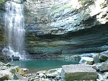
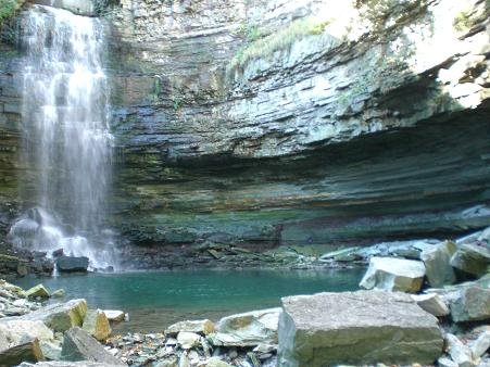
Chedoke FallsLocation Hamilton, Ontario Coordinates 43°14′30″N 79°54′02″W / 43.241576°N 79.900475°W Type Ribbon Total height 15.5 m (51 ft) Total width 2 m (6.6 ft) Watercourse Chedoke Creek Chedoke Falls is 15.5 metre urban ribbon waterfall found atop the Niagara Escarpment in Hamilton, Ontario, Canada.[1][2]
The watercourse is the Chedoke Creek, an urban creek that runs through the west end of Hamilton and crosses the Bruce Trail and the Radial Trail. Denlow Falls can be found nearby just east of Chedoke Falls.
Nearby attractions include the Bruce Trail, Canadian Football Hall of Fame Museum, Copps Coliseum.[3]
Lower Chedoke Falls is an irregular curtain waterfall found a few hundred metres north of the main Chedoke Falls. It is 16-metres in height and 31-metres wide.[4]
Contents
Directions
Access to these waterfalls are not easy. Best view of it would be to bring good pair of hiking boots and travel by foot. Above the falls is a residential area. Below the gorge is a golf course. You get a limited view of the falls from Scenic Drive. Chedoke Falls can be accessed via the Chedoke Radial Trail which can be accessed via Dundurn Street South near the Chedoke Beddoe Civic Golf Course.[2]
References
- ^ "Hamilton- City of Waterfalls (Ecklund Marketing Group)". http://www.cityofwaterfalls.ca/waterfall_types.html. Retrieved 2008-06-19.
- ^ a b "Great Lakes Waterfalls & Beyond- Chedoke Falls". http://www.gowaterfalling.com/waterfalls/chedoke.shtml. Retrieved 2008-06-19.
- ^ Hamilton Waterfalls and Cascades: Research & Inventory Report, 2nd Edition. Hamilton Conservation Authority. November 2007.
- ^ "Waterfalls of Ontario.ca- Lower Chedoke Falls". http://www.start.ca/users/mharris/waterfalls/chedoke-falls--lower-.html. Retrieved 2008-06-19.
External links
- Bruce Trail (www.brucetrail.org)
- Hamilton- "The Waterfall Capital of the World" (www.cityofwaterfalls.ca)
- Vintage Postcards: Waterfalls in and around Hamilton, Ontario
Maps
- Hamilton Waterfall Map PDF. (http://map.hamilton.ca)
- Map: Hamilton Waterfalls (www.hamiltonnature.org)
Hamilton, Ontario Features History 1930 British Empire Games · Auchmar · Bank of Hamilton · Battlefield House · Battle of Stoney Creek · Dundurn Castle · George Hamilton · Grand Lodge of Canada · Hamilton Tigers (NHL) · HMCS Haida · List of royal visits · Studebaker Canada Ltd. · Tim Hortons · Thomas McQuesten · Timeline of events · Toronto, Hamilton and Buffalo Railway · USS Hamilton · USS Scourge · War of 1812 · WhitehernGeography 100+ waterfalls of Hamilton · Bruce Trail · Cootes Paradise · Desjardins Canal · Golden Horseshoe · Hamilton Harbour · Lake Ontario · List of neighbourhoods in Hamilton · Niagara escarpment · Royal Botanical Gardens · Spencer Gorge / Webster's Falls Conservation AreaPlaces in Hamilton Economy Arcelor Mittal / Dofasco · Economic history · Film industry in Hamilton · Hamilton Health Sciences · Head offices in Hamilton · List of tallest buildings in Hamilton · U.S. Steel / StelcoPolitics Public services Hospitals Chedoke Hospital · Hamilton General Hospital · Juravinski Cancer Centre · Juravinski Hospital · McMaster Children's Hospital · McMaster University Medical Centre · St. Joseph's Healthcare Hamilton · St. Peter's HospitalEducation Hamilton Public Library · Hamilton-Wentworth Catholic District School Board · Hamilton-Wentworth District School Board · Hillfield Strathallan College · Columbia International College · McMaster Divinity College · McMaster University · Mohawk College · Redeemer University College · Hamilton Literacy CouncilCulture African Lion Safari · Around the Bay Road Race · Art Gallery of Hamilton · Canadian Football Hall of Fame · Canadian Warplane Heritage Museum · Dundas Cactus Festival · Hamilton Bulldogs · Hamilton Tiger-Cats · Labour Day Classic · List of Attractions in Hamilton · Media in Hamilton · Power Play (TV series) · Sports in Hamilton · Sports venues in HamiltonTransportation  The Hamilton portalCategories:
- Waterfalls of Hamilton, Ontario
- Niagara Escarpment
- Golden Horseshoe geography stubs
Wikimedia Foundation. 2010.