- Chaves Municipality, Portugal
-
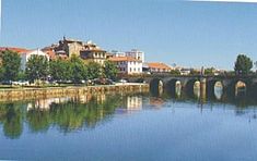
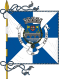
Chaves Municipality (Concelho) A vista of the municipal seat of Chaves along the Tâmega RiverFlagCoat of armsOfficial name: Concelho de Chaves Name origin: chaves, Portuguese for keys Country  Portugal
Region Norte Subregion Alto Trás-os-Montes District Vila Real Municipality Chaves Civil Parishes (see text) Landmark Trajan's Bridge River Tâmega River Center Santa Maria Maior - elevation 371 m (1,217 ft) - coordinates 41°44′26″N 7°28′17″W / 41.74056°N 7.47139°W Length 44.45 km (28 mi), Southwest-Northeast Width 26.58 km (17 mi), Northwest-Southeast Area 591.23 km2 (228 sq mi) Population 44,186 (2004) Density 74.74 / km2 (194 / sq mi) LAU Concelho/Câmara Municipal - location Largo de Camões, Santa Maria Maior, Chaves - elevation 364 m (1,194 ft) - coordinates 41°44′24″N 7°28′19″W / 41.74°N 7.47194°W President João Gonçalves Martins Batista (PPD-PSD) Municipal Chair António Vicente de Almeida e Silva (PPD-PSD) Timezone WET (UTC0) - summer (DST) WEST (UTC+1) ISO 3166-2 code PT- Postal Zone 5400-150 Chaves Area Code & Prefix (+351) 276 XXX XXX Demonym Flaviense Municipal Address Largo de Camões
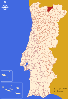
5400-150 ChavesMunicipal Holidays 8 July Location of the municipality of Chaves in continental PortugalWikimedia Commons: Chaves Website: http://www.chaves.pt Statistics from INE (2004); geographic detail from Instituto Geográfico Português (2010) Chaves (Portuguese pronunciation: [ˈʃavɨʃ]) is a municipality and municipal seat of an area (591.3 km²) 10 km south of the Spanish border and 22 km south of Verín (Spain) in the north of Portugal. The municipality is the second most populous of the district of Vila Real (the district capital, Vila Real, is 60 km south on the A24 motorway). With origins in the Roman civitas Aquæ Flaviæ, Chaves has developed into a regional center with a population of 44,186 (2004), of whom, 17,535[1] reside in the urban area.
Contents
History
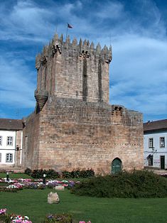
The remnants of ancient Keep of the Castle of Chaves
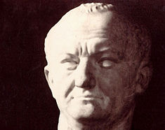
Artefacts discovered in the region of Chaves identify the earliest settlement of humans dating back to the Paleolithic.[2] Remnants discovered in Mairos, Pastoria and São Lourenço, those associated with transient proto-historic settlements and castros, show a human presence in the Alto Tâmega dating to the Chalcolithic.[2] The region has seen persistent human settlement since Roman legions conquered and occupied the fertile valley of the Tâmega River, constructing a nascent outpost and taking over the existing castros in the area. The settlement was located at the convergence of three important Roman roads: the Bracara Augusta, Asturica, and Lamecum that crossed the Roman Province of Gallaecia, linking Rome to the region's natural resources.[2] It was a military centre known for its baths, which lasted until the 16th century. This civilization constructed protective walls to protect the local population; spanned the river with the bridge;[3] promoted the baths (with its warm medicinal waters); exploited local mines and alluvial deposits and other natural resources. Its importance led to the urban nucleus being elevated to the status ofmunicipality in 79 AD, during the reign of the first Flavian Caesar, Titus Flavius Caesar Vespasianus Augustus.[2] Its benefactor consequently influenced its toponymy, becoming known as Aquae Flaviae. Artefacts from the area around the Matriz church indicate that Aquae Flaviae's centre was located in this place, in addition to an ancient headstone showing gladiatorial combat.[2][4]
Rome's hegemony lasted until the 3rd century, when, successively, the proto-Germanic Suebi, Visigoths and Alaunt tribes colonized the imperial settlements of Chaves.[2] Wars betweenRemismund and Frumar followed over their claims to the throne, which almost completely destroyed the village (it was settled in favour of Frumar, who imprisoned Idácio, the notable Bishop of Chaves).[2] Ironically, the Romans were complicit in Aquae Flaviae's near destruction.[5] Barbarian dominion lasted until the Moors invaded from North Africa, defeating the Visigoth King Roderic at the beginning of the 8th century.[2]
In course, the name of Aquae Flaviae began to disappear, being supplanted by the more Hispanic-sounding Aquae Calidae (English: hot waters).[6]
Arab rule of the Iberian peninsula forced many Christians to escape from Chaves into the mountains in the northwest. Battles between the Christians and Muslim forces then continued until the 11th century, whenAfonso Henriques partially reconquered the territory.[2] But, by the first quarter of the 10th century it was reconquered by the Moors. It was not until the reign of Afonso III that it was firmly integrated into the kingdom's domain (1160).[2] After finally defeating the last vestiges of Moorish influence, he reconstructed, settled and encircled the settlement of Chaves with walls, in addition to establishing a judiciary in the community. Owing to its geographic location (on Portugal's northern frontier with Spain), King Denis, ordered the construction of a castle to protect the kingdom's border.[2]
During the reign of Afonso II, when the king continued to provoke the ire of the Papacy, Portuguese knights attacked the Galician tenancy of his half-brother Martin Sanches (who lived in the kingdom of Alfonso IX of León), possibly since the Bishop of Braga had estates in that region. Provoking Sanches to invade northern Portugal.[7] The Leonese fought battles in Barcelos, Braga and Guimarães, where they defeated Portuguese forces, before retiring to Galicia with their spoils.[7] At the same time, Alfonso IX of León seized Chaves, which remained in Leonese hands until the reign of King Sancho II, when he and Ferdinand III met in 1230/1231.[7][8] This was likely a self-serving decision on Fernando's part, as he was fearful that Leonese barons would support Sancho against him. Alfonso IX continued to occupy Chaves as a method of ensuring his wife, Teresa, would be able to enjoy her properties in Portugal.[8]
During the Portuguese Interregnum, the nobility of Chaves supported Beatrice of Portugal, as she was heir presumptive to King Ferdinand I, since the he left no male heirs. The potential loss of independence of Portugal, through her marriage to John I of Castile resulted in the rebellion by the Master of the Order of Aviz (later King John I of Portugal), who would garner the support of the Portuguese Cortes, thus laying the seeds for his triumph at the Battle of Aljubarrota.[9] Yet, many nobles refused to break their oaths of fielty to Beatrice (including in Chaves), necessitating John's travel to Porto in force and scaring the nobles of Chaves and Bragança into capitulating.[9]
The remnants of the Roman baths, and the houses used to assist the invalid, were demolished by the Count of Mesquitella at the end of the 17th century, in order to reinforce the defense of Chaves.[10]
French forces invaded and attacked in 1807, during the Siege of Chaves, part of the Peninsular Wars.[11] On 7 March 1808, Soult's forces invaded northern Portugal to remove British forces from Iberia. Brigadier Francisco da Silveira was charged with the defense of Chaves, but his 6000 men were unable to support its defense, and quickly abandoned the castle.[12] An attempt to defend Chaves by Francisco Pizarro was futile, and the city surrendered to French forces shortly after the engagement. With too many troops to imprison Sault released many under oath, in order to continue the attack on the main forces who had retreated to the south.[12] But Francisco Pizarro did not quit, and as the main French went on to defeat the Anglo-Portuguese alliance at the First Battle of Porto, Pizarro retook Chaves.
On 20 September 1837, the Convention of Chaves, which followed the Battle of Ruivães and which ended Chartist or Marshall's Revolt, was signed in Chaves.[2] Chaves was also a site of various religious apparitions, during the decade of 1830, eventually resulting in the construction of the Santuário da Nossa Senhora Aparecida (Portuguese: Sanctuary of Our Lady Revealed).[2]
On 8 July 1912, forces loyal to the former monarchy, under the command of Henrique Paiva Couceiro, confronted government forces, chefed by Colonel Ribeiro de Carvalho, during the second monarchist incursion.[2][13][14]
On 12 March 1929, the town of Chaves was elevated to the category of city.[2]
Geography
Physical geography
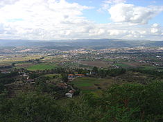
Chaves is in the extreme north of Portugal, bounded on the north by Galicia (Spain), on the east by the municipalities of Vinhais and Valpaços, on the south by the municipality of Vila Pouca de Aguiar and on the west by the municipalities of Montalegre and Boticas. Chaves is one of the six municipalties of the Alto Tâmega, situated in the district of Vila Real, strategically positioned in the northwest of the Iberian peninsula and accessed by important international highways.
The region is dominated by the Quaternary Chaves sedimentary basin, a graben aligned on a north-northeast to south-southwest orientation bounded by the Hercynian massif and metamorphic schistose formations.[15] Mixed with the schistose complex, there are bands of graphitic slates, mainly in the southern part of the urbanized area of Chaves and south-east of Faiões.[15] To the north, and into Galicia, the basin extends into the depression of the Verin Basin. One of the oldest formations in the region, it dates back to the Ordovician period ( between 488.3±1.7 to 443.7±1.5 million years ago), is composed of schist and graywacke deposits.[15] During the Ordovician-Silurian geological periods quartzites and schists were formed, metamorphosed by Hercynian granitic intrusions, at the end of the Paleozoic.[15]
The Alpine orogeny was the main cause of extensive tectonic activities and it was responsible for the formation of the hydrothermal field within the region.[16] The Chaves graben was formed by the relative motion of the block with different types of sediments being settled. The most recent formations are a sedimentary series (lacustrine, alluvial, colluvial, detritic, etc.) with variable thickness that had their origin during the Miocene.[16][17] Two main faults cross and influence the tectonic activities: the north-northeast by south-southeast Chaves-Verin Fault and a fault system crossing near Faiões and Santo Estêvão.[16] The first fault developed from late Hercynian tectonic episode occurring between 280 and 300 million years ago, that developed into an almost north-south direction into the lithosphere.[16][18] Intense neotectonic activity reactivated these old fractures, originating in a complex pattern of faults in the sedimentary basin.[16]
Thermal springs
Mineral waters are the clearest evidence of these recent tectonic fractures. The Penacova-Régua-Verín Fault, is an active formation that extends longitudinally for 500 kilometres, intermingled with other faults resulting in subterranean hydrology.[16] The thermal springs, principally those in Campilho and Salus Vidago (in Vila de Vidago) have developed from this mixture of circumstances. With temperatures reaching 73 °C (163 °F), these mineral springs (bicarbonates, sodium, silicates and fluoride) in the vicinity of the city of Chaves, have provided a potential source of income.[16]
The hot springs (Portuguese: Caldas) were known since the Roman period, when the town was Aquae Flaviae; the Waters of Flavius were an important social gathering point, but fell into disuse as the town was slowly abandoned by attacks. The spas belong to a vast area of hydrothermal springs that stretch from Verín (in Galicia) to Pedras Salgadas, 30 km from Chaves (on the road to Vila Real). Despite its vastness and abundance of water, this thermal system is little utilized; of the nine groups of thermal springs there are only adequate installations in four of them: Chaves, Carvalhelhos, Vidago, Pedras Salgadas, and Verín. The waters of the spring, that are captured in three springs within Chaves, have mean temperatures of 73 °C (163 °F) (the hottest bicarbonate waters in Europe). The modern spa industry in Chaves use these waters for numerous treatments, including stomach, liver, intestinal, and kidney ailments, through oral ingestion. Many small guesthouses in the old part of the town are dependent on the influx of these visitors. The thermal spas are located between the castle and the river, in front of a large area of grass-covered park with playgrounds and tennis courts.
Climate
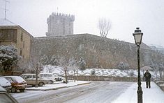
The climate in Chaves is transitional between Atlantic Maritime Temperate and Continental. The mountains between the Minho region and Trás-os-Montes serve as a climatic barrier and lessen rainfall closer to the interior. Winters can be cold; January highs rarely reaching 10 °C (50 °F) and lows often are below zero. In addition to thick fog hovering over the valley, common on dry summer days are characterized by maximums around 38º and minimums around 15º. Summer brush fires can often make this season unpleasant.
Climate data for Chaves, Vila Real Month Jan Feb Mar Apr May Jun Jul Aug Sep Oct Nov Dec Year Average high °C (°F) 9.0
(48.2)11.0
(51.8)15.0
(59.0)16.0
(60.8)20.0
(68.0)25.0
(77.0)29.0
(84.2)29.0
(84.2)25.0
(77.0)18.0
(64.4)13.0
(55.4)9.0
(48.2)18.2 Average low °C (°F) 2.0
(35.6)2.0
(35.6)4.0
(39.2)5.0
(41.0)8.0
(46.4)12.0
(53.6)14.0
(57.2)14.0
(57.2)12.0
(53.6)9.0
(48.2)5.0
(41.0)3.0
(37.4)6.7 Precipitation cm (inches) 7.64
(3.008)3.59
(1.413)4.04
(1.591)3.95
(1.555)5.07
(1.996)2.17
(0.854)1.38
(0.543)1.35
(0.531)3.43
(1.35)7.9
(3.11)5.9
(2.32)8.68
(3.417)7.9
(3.11)Source: Instituto de Meteorologia (FORECA).[19] Human geography
Government is administrated by the Municipal Chamber of Chaves (Portuguese: Câmara Municipal de Chaves), while locally the municipality is divided into local councils, that include:
- Águas Frias
- Anelhe
- Arcossó
- Bobadela
- Bustelo
- Calvão
- Carvela
- Cela
- Cimo de Vila da Castanheira
- Curalha
- Eiras
- Ervededo
- Faiões
- Lamadarcos
- Loivos
- Maços
- Madalena
- Mairos
- Moreiras
- Nogueira da Montanha
- Oucidres
- Oura
- Outeiro Seco
- Paradela
- Póvoa de Agrações
- Redondelo
- Roriz
- Samaiões
- Sanfins
- Sanjurge
- Santa Cruz-Trindade
- Santa Leocádia
- Santa Maria Maior
- Santo António de Monforte
- Santo Estêvão
- São Julião de Montenegro
- São Pedro de Agostém
- São Vicente
- Seara Velha
- Selhariz
- Soutelinho da Raia
- Soutelo
- Travancas
- Tronco
- Valdanta
- Vidago
- Vila Verde da Raia
- Vilar de Nantes
- Vilarelho da Raia
- Vilarinho das Paranheiras
- Vilas Boas
- Vilela do Tâmega
- Vilela Seca
Demographics
Population of
Chaves
(1801 - 2008)Year Pop. ±% 1801 31,651 — 1849 17,356 −45.2% 1864 31,815 +83.3% 1900 36,781 +15.6% 1930 40,702 +10.7% 1960 57,243 +40.6% 1981 45,883 −19.8% 1991 40,940 −10.8% 2001 43,667 +6.7% 2008 44,039 +0.9% In the past 127 years, the municipality has seen a 29% increase in local population (from 31815 in 1864 to 40940 in 1991). This was not a gradual nor homogeneous increase, since there were periods of extreme growth or rapid decline. During the 20th century, growth after 1920 is notably influenced by the restriction of trans-Atlantic emigration, just like after 1991, the population decreases were associated with liberal emigration policies as a result of the Maastricht Treaty.
The parish populations have seen fluctuations, although the most recent census show that 31 of these agglomerations had population levels in 1991 much lower than their first tabulation. Further, analysis of the data identifies that the municipal increase (29%) was primarily from the more urbanized parishes, while peripheral rural/mountainous parishes show net decreases. Many of the local people have emigrated to settlements in northern Europe in addition to France, but commonly return or visit their villages for weddings or village festivals.
Chaves has been isolated from the coastal urban centers and has suffered from a lack of convenient road communications. Recently, a new four-lane highway (A24) was opened to traffic. It links Chaves to Vila Real, and to the border with Spain. In Vila Pouca de Aguiar the highway also connects with the A7 that leads to Porto.
City
The population of the city encompasses 17,535 residents in the parishes of Santa Cruz-Trinidade, Madalena, and Santa Maria Maior: these parishes form the urbanized population of the city of Chaves.
Although many of the older buildings outside the historical walls were demolished to make way for apartment blocks, the medieval quarter with its Rua Direita and Rua de Santo António have been declared historic zones. In these areas there are narrow multi-story dwellings, whose origin has been limited by the walled city. Historically, the old quarter was the city, and few buildings were located outside its walls, since its frontier location and the imminent risk of invasion impeded the construction of homes outside the barriers. Consequently, space was limited and land primarily used for multi-purpose dwellings, resulting in very narrow streets and multi-story structures (with balconies that extend over the streets and protected the citizenry). Many of the lower floors were occupied by shops or small businesses, while the residents lived in the upper stories. Remnants of these verandas are still visible in the medieval quarter.
The walled city was at the forefront of the political turmoils during the Reconquista, transited by armies and sacked by enemies. Chaves was built, destroyed, and rebuilt several times by either faction (Christian and Muslim), when they occupied the castle (it is likely that for some periods the town was completely abandoned). In 1253, Afonso III supported the reconstruction of the castle. By 1258, Chaves was granted the status of a vila (or town). While the walls were eventually rebuilt, the advent of artillery would make the castle's fortifications obsolete, and its importance wained, while the historical battlements fell into ruins.
On 15 November 2009 an extensive green space on the east side of the Tâmega River, between the Engenheiro Carmona Bridge and the Public Gardens, was opened to the public. It is an area with playgrounds, pedestrian and cycling paths, a beach football pitch, and a large grassy area. A modern pedestrian bridge was constructed to link the park and recreational area with the hot springs on the west bank of the river. At the same time cycling and walking paths were built on both banks of the river extending north for several kilometers. The pedestrian bridge, which is approximately 90 ft, is Chave's tallest and most expensive bridge.
Economy
Agriculture and services are still the main sources of income. The traditional prosperity of Chaves comes, mainly, from a highly fertile plain, nine kilometres long and three to five wide, referred to as the"veiga". Since the land can be irrigated with canals there is intensive farming of potatoes, corn, rye, hay, while plots of vegetables are also commonplace in the local market. The main canal begins near Vila Verde da Raia and crosses the valley on the right bank of the Tâmega as far as Nantes. On the whole, the land is made up of small plots that are rarely economically viable. There is some dairy farming, and a milk production unit on the south side of town, but few cows can be seen in the valley. In general most of the farmers are of retirement age and farming is often pursued more as a hobby than as a profession.
In addition to agriculture there are some small industries producing glass, tiles, and food products. Like Vila Pouca de Aguiar, located thirty kilometres south, this is a land of granite; there are several granite extraction and finishing industries located in Chaves, in addition to three brickworks, located on the south side of the city. Further, two mineral water plants, located in Vidago, belong to the municipality.
Transportation
It is serviced by A24 motorway, which links Chaves with the south, to Viseu, Coimbra and Figueira da Foz, connecting to Vila Pouca de Aguiar by the A7 (which acts as the gateway to the southern Trás-os-Montes), and the N103 from Bragança to Braga. Chaves is located 415 kilomtres from Lisbon, 105 kilomtres from Porto and just 55 kilometres from the district capital, Vila real.
Architecture
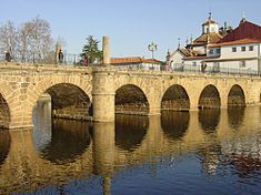 Trajano's Bridge, the Roman bridge emblematic of the municipality of Chaves
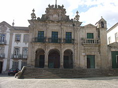
 The Church of the Misercórdia, built in the 17th century, is the dynastic resting place for members of the House of Braganza
The town of Chaves is built upon a long military history, that includes many fortifications or vestiges of battlements. Apart from the medieval castle and 17th century forts (Forte de São Francisco andForte de São Neutel), two medieval fortifications still exist: Santo Estêvão Tower (in the village of the same name north of Chaves) and Monforte Castle (in the hills east of the town).
Civic
- Roman bridge - the Roman era bridge, emblematic of the city of Chaves, was constructed during the reign of Emperor Trajan to span the Tâmega River, in order to connect the Roman provincial settlements of Astorga (in Spanish León) and Bracara Augusta (now Braga) in Gallaecia. The structure still has Roman inscriptions on the principal columns, that identify the bridge and its dedication to Emperor Caesar Vespasianus Augustus.
Military
- Castle of Chaves - National monument since 22 March 1938, King Denis built the Chaves Castle in the 14th century, but today only the iconic Torre de Menagem (prison block) remains. The history of this castle is fused with the history of Chaves, a defensive structure during the Christian Reconquista. In 1383 King John I donated the town and the castle to the Condestável Nuno Álvares Pereira, who helped defeat the faction opposed to the new king and who were occupying the castle. This knight included the castle in the dowry of his daughter Beatriz when she married Afonso, Count of Barcelos, King John’s illegitimate son, who would later became the first Duke of Braganza (1371–1456).
- Forte de São Francisco (English: Fort of São Francisco) - during the Middle Ages Chaves was defenseless from its unprotected border with Galicia. There was a realization that the nearby hilltops required garrisons to defend the region and prevent an occupation from León. Early plans suggested the construction of a hill fort in Pedisqueira, where a Franciscan convent already existed. But it was only at the end of the Portuguese Restoration War (1640–1668), that a fort was finally built. During the Napoleonic invasions (in 1807) the fort was captured by Marshall Soult, but retaken when a light garrison was left to guard it. It later became a centre for several pro-royalist revolts in the early 18th century, and later in 1910, after the establishment of the First Republic. In a reasonable state of preservation, the fort was acquired by a hotel group and four star hotel was adapted to the old building. The simple fort is based on the Vauban system, planned in a four-pointed star configuration, with each convergence serving as a lookout tower. The walls are all of granite, with about one meter of thickness. The height varies according to the slope of the terrain, but the maximum point has 20 meters. The main entrance faces the south, with a drawbridge over the moat that no longer exists. There are other gates, to the east and west. In addition to the old Church of São Francisco (which for three centuries was resting place of the first Duke of Braganza), there are other buildings which have been artistically converted into hotel rooms, and which served the army as barracks for many years.[20]
- Forte de São Neutel - This fort was built to protect the northern hill against a possible invasion from Spain during the Portuguese Restoration War in the 17th century. It wasn’t connected to the defense system of Chaves so its builders had to provide it with a second external wall and an internal moat based on the Vauban system. It follows the irregularities of the terrain and it also has a quadrangular design, having on the corners towers that extend out over the moat. Because of the moat the access to the interior was made across a solid stone bridge. The walls are a meter and a half thick and 7 to 10 meters high, made of granite, while inside a chapel was dedicated to Our Lady of the Springs (Portuguese: Nossa Senhora das Fontes), where there is an annual pilgrimage. There are also small buildings that were constructed to house a military garrison, and a garrison is still located in the vicinity of the Fort.
Religious
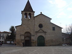
- Church of Santa Maria Maior - Santa Maria Maior, or the Matriz Church is historical cathedral (long since decommissioned when the bishopric was transferred to Vila Real); in 716, during the Moorish invasion, there was no longer a bishopric in Chaves.[21] Its construction dates to the year 1100, the church is a Romanesque design consisting of a main nave and bell tower. During 16th century, renovations were completed in the Renaissance-style, which completely modified the church (it was restored in 1968). Today, it conserves its Romanesque-style solid granite blocks and austere facade, broken only by the side door of elegant proportions (with busts of Saint Peter and Saint Paul), while a statue of Santa Maria Maior is located on a wall to the rear of the temple. The interior, consists of three naves separated by four cylindrical columns, with eight arches; a stone-ribbed dome covering the main chapel; austere walls; stained glass; and an unpainted oak ceiling supporting the roof.
- Church of Madalena - located on the left bank of the Tâmega River, the Church of São João de Deus dates from the 18th century, built during the reign of King John VI, who maintained it (his coat-of-arms appears on the main door), it was originally constructed as a chapel for the military hospital (located next to the temple).[22] The church includes neoclassic and baroque elements, including a very high façade, making it difficult to view from the narrow street.
- Church of the Misericórdia - built in 17th century, the Baroque church was the main chapel of the Dukes of Bragança: a relatively small temple with the four façade Greek columns, mythological sculptures, and surmounted by Nossa Senhora da Misericórdia (Portuguese: Our Lady of Mercy) looking down on ten figures (and covering them with her mantle). The interior is totally covered in blue-and-white azulejo tiles from the 18th century, depicting figures and biblical scenes, and its wooden ceiling is painted in bright colours representing the scene of the Visitation, painted by Jerónimo Rocha Braga (1743). The wooden altarpiece (Portuguese: retábulo) is decorated with cherubs, bunches of grapes, and spiral shells in the Manueline-style decoration.
- Chapel of São Caetano - located 7 km from the municipal Chaves, it was constructed in honour of Saint Cajetan, a Theatine orator of the Catholic Church during the Counter Reformation. The local community celebrate festivals on 7 August, when seven images of the saint are carried by the faithful in popular religious processions. The saint is sought, for granting supplications, as mundane as getting better grades at school or a good crop (in this agricultural community).
- Chapel of Nossa Senhora de Aparecida - in the village of Calvão, it was constructed on the site of a Marian apparition in 1833, when three shepherd children (similar to the events in Fátima) witnessed the Virgin Mary.
- Chapel of Nossa Senhora da Engaranho - located in Castelões (15 km from Chaves) , an uncommon invocation to the image of Mary, responsible for aiding those with diseased-, crooked- or crossed-legs, or afflictions associated with walking. Families and young children commonly visit the chapel, requiring a ritualized washing in a small grottoe, located next to the chapel.
Notable citizens
- João Gonçalves da Costa (c. 1720 – Manuel Vitorino, Bahia; c. 1820) - was an explorer and conquistador, who, at 16 years of age went to Brazil, in the service of King John V, conquering lands in the Sertão da Resaca, fighting local native tribes, and founding the village of Vitória da Conquista, in the state of Bahia;
- Rodrigo Domingos de Sousa Coutinho, 1st modern Count of Linhares (4 August 1755 — Rio de Janeiro, 26 January 1812), a diplomat, politician, Minister and Secretary of State for the Navy and Overseas Dominions (Portuguese: Ministro/Secretário de Estado da Marinha e Domínios Ultramarinos), in the council of King Joseph I, and the Prince Regent John IV;
- Agostinho de Sousa Pinto de Barros Cachapuz (31 July 1783 - 7 August 1864), an officer during the Peninsular Wars and Liberal Wars, he was a colonel of the militia, serving under the Marquess of Chaves, decorated for his defense of legitimist ideals;
- Nadir Afonso Rodrigues, GOSE (4 December 1920 –) - a geometric abstractionist painter, formally trained in architecture, but who later studied painting in Paris, becoming one of the pioneers in the Kinetic art movement;
- Cândido Sotto Mayor (Lebução; 26 October 1852 - Lisbon, 29 October 1935), a philanthropist responsible for the main Garden in Chaves, but also as the founder of the Banco Sotto Mayor (English: Sotto Mayor Bank);
- António Joaquim Granjo (27 December 1881 — Lisbon, 20 October 1921), was a lawyer and politician, assassinated as Minister of the Interior, during the infamous Noite Sangrenta(English: Bloody Night) on 19 October 1921;
- Francisco da Costa Gomes, ComTE, GOA (Chaves; 30 June 1914 – (Lapa) Lisbon; 31 July 2001), was a military officer, politician, the 15th President of the Portuguese Republic (the second after the Carnation Revolution), known for his brokered military agreement between UNITA against the MPLA and the FNLA (in Portuguese West Africa), and his refusal to swear public loyalty to the President of the Council of Ministers Marcello Caetano;
- Francisco Gonçalves Carneiro (Chaves, 20 July 1915), lawyer, museum curator and writer;
- Gentil de Valadares (25 February 1916 - Alvor, 17 September 2006), a poet, known as the poet traitor during the Estado Novo regime for his work "Coração" against the Colonial Wars, and imprisoned by the PIDE (secret police) his homage to writer José Maria Ferreira de Castro;
- Mário Gonçalves Carneiro (7 December 1917 - 5 July 2008), a surgeon and director of the Caldas de Chaves; promoted a modern thermal park system in the Alto Tâmega region, that includes the Chaves spa;
See also
References
- Notes
- ^ Uma população que se urbaniza, uma avaliação recente - Cidades, 2004 Nuno Pires Soares, Instituto Geográfico Português (Geographic Institute of Portugal)
- ^ a b c d e f g h i j k l m n o "História do Concelho [History of the Chamber]". Chaves, Portugal: Município do Concelho de Chaves. 2010. http://www.cm-chaves.pt/Default.aspx?ID=32. Retrieved 14 April 2011.
- ^ The construction of the bridge was a remodelling of the existing bridge, which was constructed by various tribes that already lived in the vicinity (CUP, 1970, p.13)
- ^ Discovered in 2006, the archeological remnants were found and removed to the Museu da Região Flaviense (English: Museum of the Flavian Region).
- ^ Thompson (1982), p.167; Hydatius wrote: Inter Frumarium et Rechimundum oritur de regni potestate dissensio ("Between Frumar and Rechimund arose a dissension of the power of the kingdom")
- ^ Robert Southey (1827), p. 172
- ^ a b c CUP (1970), p.117
- ^ a b CUP (1970), p.122
- ^ a b CUP (1970), p.179
- ^ Robert Southey (1827), p.173
- ^ CUP (1970), p.400
- ^ a b Robert Southey (1827), p.174
- ^ The Republican forces were eulogized in toponomic references in Lisbon, with the designation of an avenue in their honour (Avenida Defensores de Chaves), between Avenida Casal Ribeiro and Campo Pequeno.
- ^ CUP (1970), p.452
- ^ a b c d Santos et al. (1997), p.87
- ^ a b c d e f g Santos et al. (1997), p.88
- ^ UTAD, ed. (1992)
- ^ Santos et al. (1995)
- ^ "Weather Information for Chaves, District of Vila Real". http://meteorologia.pt.msn.com/monthly_averages.aspx?wealocations=wc:POXX0047&q=Chaves%2c+Vila+Real+forecast:averagesm. Retrieved 14 April 2011.
- ^ Later, these rooms were used to lodge families that had returned from the Portuguese colonies when these got their independence in the 1970s.
- ^ The last bishop, Idacio (who remained in this position for 40 years) was Roman bishop in the 5th century (during the period of Suevian invasions along the northwest corner of the Iberian Peninsula). Frumario, a barbarian king who destroyed the city, imprisoned the clergyman, but was later released and returned to his church (which had been severely damaged). The Visigoths later destroyed the structure.
- ^ The military hospital, the School of Anatomy and Surgery of Chaves, was one of the four schools of surgery in the country, which lasted until the last century.
- Sources
- UTAD, ed. (1992), Evaluation of Geothermal Resources Between Lamego e Vila Verde da Raia: Geological Final Report (Program JGULE/ECE-JOUG-0009-C), Vila Real, Portugal: Universidade de Tras-os-Montes e Alto Douro (UTAD)
- Monteiro Santos, F.A.; Dupis, A.; Andrade Afonso, A.R.; Mendes-Victor, L.A. (1995), "Magnetotelluric Observations Over the Chaves Geothermal Field (NE Portugal): Preliminary Results", Phys. Earth Planet. Inter., pp. 208–211
- Santos, Fernando Ackio Monteiro; Afonso, Anthio Roque Andrade; Victor, Luis Alberto Mendes (1997), "Study of the Chaves Geothermal Field Using 3D Resistivity Modeling", Journal of Applied Geophysics, Cambridge, England: Elsevier, pp. 85–102, http://www.gein.noa.gr/services/vassilis/3.pdf
- CUP, ed (1970). History of Portugal: Pamphlet Collection. CUP Archive. ISBN 1-00-128780-0. http://books.google.ca/books?id=fHI3AAAAIAAJ&pg=PA400&dq=history+chaves+portugal#v=snippet&q=chaves&f=false.
- Thompson, E. A. (1982), Romans and Barbarians: The Decline of the Western Empire, Madison, Wisconsin: University of Wisconsin Press, ISBN 0-299-08700-X
- Southey, Robert (1827), The History of the Peninsular War, 2, London, England: John Murray, http://books.google.ca/books?id=JjoPAAAAYAAJ&printsec=frontcover#v=onepage&q&f=false
External links
- Termas de Chaves - Official website of the thermal spa of Chaves
- Confraria de Chaves - Official website of the Confraria de Chaves that promotes cultural products from the region
- Grupo Desportivo Chaves
Alijó · Boticas · Chaves · Mesão Frio · Mondim de Basto · Montalegre · Murça · Peso da Régua
Ribeira de Pena · Sabrosa · Santa Marta de Penaguião · Valpaços · Vila Pouca de Aguiar · Vila Real Categories:
- Cities in Portugal
- Municipalities of Portugal
- Populated places established in the 1st century
- Chaves, Portugal
Wikimedia Foundation. 2010.

