- Montalegre Municipality
-
Montalegre Municipality (Concelho) 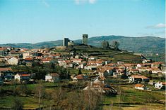 A view of the hilltop Castle of Montalegre in the municipal seat of the municipality
 Flag
Flag Coat of arms
Official name: Concelho de Montalegre Name origin: montalegre Portuguese contraction for monte (mountain) + alegre (happy) Country  Portugal
Region Norte Subregion Alto Trás-os-Montes District Vila Real Municipality Montalegre Civil Parishes (see text) Center Montalegre - elevation 884 m (2,900 ft) - coordinates 41°45′25″N 7°50′58″W / 41.75694°N 7.84944°W Length 49.04 km (30 mi), Southwest-Northeast Width 37.69 km (23 mi), North-South Area 805.46 km2 (311 sq mi) Population 12,150 (2001) Density 15.08 / km2 (39 / sq mi) LAU Concelho/Câmara Municipal - location Praça do Municipio, Montalegre, Montalegre - elevation 986 m (3,235 ft) - coordinates 41°49′23″N 7°47′30″W / 41.82306°N 7.79167°W President Fernando José Gomes Rodrigues (PS) Municipal Chair Joaquim Lopes Pires (PS) Timezone WET (UTC0) - summer (DST) WEST (UTC+1) ISO 3166-2 code PT- Postal Zone 5470-214 Montalegre Area Code & Prefix (+351) 276 XXX XXX Demonym Montalegrense Patron Saint Nossa Senhora da Piedade Municipal Address Praça do Municipio, 1
5470-214 MontalegreMunicipal Holidays 9 June 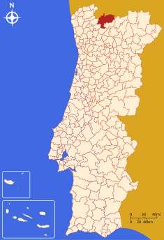 Location of the municipality of Montalegre in continental Portugal
Wikimedia Commons: Montalegre Website: http://www.cm-montalegre.pt Statistics from INE (2004); geographic detail from Instituto Geográfico Português (2010) Montalegre (Portuguese pronunciation: [mõtɐˈlɛɣɾ(ɨ)]) is a municipality in northern Portugal, located in the district of Vila Real, along the border with Spain. The municipality of 36 civil parishes has a total area of 805.46 km², and includes a population of approximately 12,150 inhabitants.
Contents
History
Early construction in Montalegre date back 3500-4000 years when early inhabitants, around the villages of Mourela, Veiga and Vila da Ponte, buried their dead in funeral mounds.[1] Vestiges of this culture predominate the region, and suggest that settlements have been ongoing since the Metal Ages.[1]
Celt colonies began to appear afterward, constructing castros in many of the places that developed into formal settlements.[1] With the arrival of the Roman, bridges and formal roads began to appear, while many of the castros began to be converted into Roman encampments, later the nuclei of formalized settlements.[1] Remains of the Roman civitas are still common: Praesidium (in Vila da Ponte, popularly known as Sabaraz) and Caladunum (in Cervos).[1]
Although there were no overt indications that the Moors settled in this region, although oral tradition inferred as much.[1]
With the establishment of the Christian kingdom of Portugal, Afonso Henriques donated portions of the land for charitable hospices (Salto), hospitals (Vilar de Perdizes and Dornelas) or monasteries (Pitões).[1] Owing to its location, on the border with Galiza, defense fortifications were constructed, including the Castles of Gerês and Piconha, and later in Portelo and the village of Montalegre.[1] A lighthouse was also constructed in Tourém, likely by King Sancho in 1187, since he was the master of the Terras da Piconha region.[1]
It was only in September 1273 that King Afonso III bestowed on the citizens a foral (charter), founding the town of Montalegre and making the local sheriff the master of the Terras de Barroso.[1] The foral was later confirmed by King Denis in 1289, and renewed by Afonso IV (in 1340), John II (in 1491), and Manuel (in 1515).[1][2]
After the Portuguese Interregum, during the reign of John I, the Terras de Barroso were offered as a gift to Nuno Álvares Pereira for his support.[1]
In 1809, French troops had problems in the region, during the Peninsular Wars, fighting off the Barrosões, in Misarela.[1]
On 6 November 1836, the municipality of Montalegre was divided, in order to create the municipality of Boticas.[1] In course, the parishes of Vilar de Vacas was lost to the neihgbouring municipality of Vieira do Minho, and later the parish of Couto Misto de Santiago de Rubiás, was also de-annexed.[1]
Contemporary history of the municipality has been marked by growing emigration, the result of the lack of economic recourse and the abandonment of traditional activities.[1] The institutionalization of local government permitted a revitalization in the municipality, after the Carnation Revolution, which saw a growth in tertiary activities.[1]
Geography
 The Alto Rabago Dam and reservoir, central to four parishes of the municipality
Montalegre is one of the two municipalities that compose the region of Barroso. The Peneda-Gerês National Park comprises 26,26% of its area (211,74 km² out of a total 806,19 km² belonging to that park).
Human geography
Administratively, the municipality is divided into 36 civil parishes that administer local area government and support the local populations:
- Cabril
- Cambeses do Rio
- Cervos
- Chã
- Contim
- Covelães
- Covelo do Gerês
- Donões
- Ferral
- Fervidelas
- Fiães do Rio
- Frades do Rio
- Gralhas
- Meixedo
- Meixide
- Montalegre
- Morgade
- Mourilhe
- Negrões
- Outeiro
- Padornelos
- Padroso
- Paradela
- Peireses
- Pitões das Júnias
- Pondras
- Reigoso
- Salto
- Santo André
- Sarraquinhos
- Sezelhe
- Solveira
- Tourém
- Venda Nova
- Viade de Baixo
- Vila da Ponte
- Vilar de Perdizes
References
- Notes
- ^ a b c d e f g h i j k l m n o p q Gabinete de Informática, ed (2011). "Resenha Histórica" (in Portuguese). Montalegre, Portugal: Câmara Municipal de Montalegre. http://www.cm-montalegre.pt/showPG.php?Id=9. Retrieved 13 May 2011.
- ^ The 1515 foral, not only renewed the town charter, but also provided for the upgrade of the lighthouse.
Alijó · Boticas · Chaves · Mesão Frio · Mondim de Basto · Montalegre · Murça · Peso da Régua
Ribeira de Pena · Sabrosa · Santa Marta de Penaguião · Valpaços · Vila Pouca de Aguiar · Vila Real Categories:
- Montalegre
- Municipalities of Portugal
- Towns in Portugal


Wikimedia Foundation. 2010.