- Camastianavaig
-
Coordinates: 57°22′40″N 6°08′59″W / 57.37785°N 6.14977°W
Camastianavaig Scottish Gaelic: Camas Dìonabhaig 
 Camastianavaig
Camastianavaig shown within the Isle of SkyeOS grid reference NC412656 Council area Highland Lieutenancy area Ross and Cromarty Country Scotland Sovereign state United Kingdom Post town Portree Postcode district IV51 9 Police Northern Fire Highlands and Islands Ambulance Scottish EU Parliament Scotland UK Parliament Ross, Skye and Lochaber Scottish Parliament Highlands and Islands List of places: UK • Scotland • Camastianavaig (also English spelling: Camustinivaig) is a crofting township on the island of Skye in Scotland. It is located on the shores of the Sound of Raasay 5 kilometres (3.1 mi) south east of Portree.[1] The Allt Osglan watercourse flows from Loch Fada through the township into Tianavaig Bay.[2]
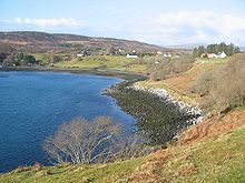 The shoreward side of Camastianvaig
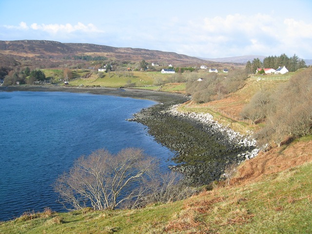
The name is from both Gaelic and Norse, Camas Dìonabhaig. "Camas" means "bay" in the former and the Norse element may be from "dyn" meaning "noisy".[3]
Contents
Tourist Activities
Camastianavaig has a rocky shore with views of the Cuillins and Raasay and is situated at the bottom of Ben Tianavaig, where there is a Sea Eagle colony. Other local wildlife includes Bottlenose Dolphin in the summer months, and seals, otters and ducks on a regular basis. The area is popular with mountain bikers.
Agriculture
The land is used for mainly crofting, with the majority of the livestock being sheep and a few cows. The land is slightly to acidic for arable farming although the addition of lime is used to compensate for this. The soil is also low in potassium, phosphorus and nitrogen, which are essential elements required for plant growth. The high levels of rainfall and steep slopes also cause soil erosion, creating further difficulties for crop growing.
Battle of the Braes
The township is near the scene of the Battle of the Braes in 1882. Local crofting tenants facing eviction from the land withheld rent and released sheep onto a forbidden area on the shores of Ben Lee. Sent to evict them, the Sheriff Officer from Portree was met by an angry mob, who forced him to burn the eviction notices. Subsequently 50 Glasgow policemen, sent to quell the rebellion, faced 100 men, women and children, armed with sticks and stones.[4][5] Small fines were imposed in court, but it was clear that law and order could only be enforced with military assistance.[6] After the Battle of the Braes, the unrest spread to Glendale, Skye. The rebellion led to the Napier Commission and ultimately the Crofters Act of 1886. which brought security of tenure and the right to hand a croft on to their heirs.[7] The Battle of the Braes is celebrated with a monument and through a folk song.[8]
References
- ^ "Camastianavaig (Camustinivaig) Highland" Gazetteer for Scotland. Retrieved 13 September 2008.
- ^ "Get-a-map" Ordnance Survey. Retrieved 13 September 2008.
- ^ Iain Mac an Tailleir. "Placenames" (pdf). Pàrlamaid na h-Alba. http://www.scottish.parliament.uk/vli/language/gaelic/pdfs/placenamesC-E.pdf. Retrieved 2007-07-23.
- ^ "Battle of the Braes". Highland Clearances. http://highlandclearances.info/clearances/clearances_battleofthebrae.htm. Retrieved 2008-09-14.
- ^ "Braes". Isle of Skye Business Community. http://www.isbuc.co.uk/Places/Braes.php. Retrieved 2008-09-14.
- ^ Jonathan MacDonald (1998). "A Short History of Crofting in Skye". http://pages.eidosnet.co.uk/~skye/crofting.html. Retrieved 2008-09-14.
- ^ "The Crofters Struggle". walkhighlands.co.uk. http://www.walkhighlands.co.uk/info/History/TheCroftersStruggle. Retrieved 2008-09-14.
- ^ "Traditional Scottish Songs - The Battle of the Braes". Rampant Scotland. http://www.rampantscotland.com/songs/blsongs_battle.htm. Retrieved 2008-09-14.
Skye / An t-Eilean Sgitheanach Main settlements Crofting townships
and settlementsAchachork · Aird of Sleat · Ardvasar · Armadale · Ashaig · Bernisdale · Bornesketaig · Boreraig · Borreraig · Borrodale · Borve · Bracadale · Breakish · Brogaig · Bualintur · Camastianavaig · Camuscross · Carbost, Loch Harport · Carbost, Portree · Claigan · Colbost · Drumfearn · Drynoch · Dunan · Duntulm · Edinbane · Elgol · Ellishadder · Eynort · Eyre · Fasach · Feorlig · Ferindonald · Fiskavaig · Flashader · Flodigarry · Galltrigill · Garafad · Geary · Gedintailor · Gillen · Glendale · Halistra · Harlosh · Heaste · Isleornsay · Kensaleyre · Kilbride · Kilmarie · Kilmore · Kilmuir · Kilvaxter · Kingsburgh · Kylerhea · Lealt · Lower Breakish · Luib · Milovaig · Ollach · Ose · Peinachorran · Portnalong · Ramasaig · Roag · Sconser · Skeabost · Sligachan · Staffin · Stein · Struan · Suladale · Talisker · Tarskavaig · Teangue · Torrin · Totaig · Tote · Treaslane · Trumpan · Uigshader · Ullinish · Upper BreakishMountains and hills Am Basteir · Beinn na Caillich · Blà Bheinn · Bruach na Frìthe · Clach Glas · Glamaig · Healabhal Bheag · Sgurr a' Ghreadaidh · Sgurr a' Mhadaidh · Sgurr Mhic Choinnich · Sgurr na Banachdich · Sgurr nan Gillean · Sgurr Dearg · Marsco · Quiraing/Meall na Suiramach · Sgurr Alasdair · The StorrHistory Armadale Castle · Battle of the Braes · Battle of the Spoiling Dyke · Caisteal Maol · Corriechatachan · Dùn Ringill · Dunvegan Castle · Fairy Flag · Flora MacDonald · Sir Rory Mor's Horn · Rubha an DùnainLocal culture Peninsulas Surrounding islands Ascrib Islands · Crowlin Islands · Eilean Bàn · Eilean Fladday · Eilean Mòr · Eilean Tigh · Eilean Trodday · Fladda-chùain · Harlosh Island · Isay · Lampay · Longay · Mingay · Oronsay · Pabay · Raasay · Scalpay · Rona · Soay · Staffin Island · Tarner Island · WiayCategories:- Populated places in Skye
- Highland geography stubs

Wikimedia Foundation. 2010.