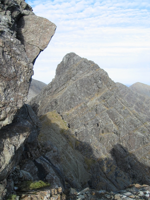
Clach Glas

Clach Glas
Clach Glas

Clach Glas viewed from Blaven
Elevation 786 m (2,579 ft)
Prominence c. 91 m
Parent peak Blaven
Listing Corbett Top
Translation Grey/blue stone (Scottish Gaelic)
Location
Location Cuillin, Scotland
Topo map OS Landranger 32
OS grid NG534221
Climbing
First ascent 1888, Charles Pilkington and party.
Easiest route scrambling (Easy–Moderate)

Clach Glas is a mountain on the Black Cuillin of Skye - its elevation is 2590 ft (789m) and the name translates as The Grey Stone. It is often traversed as a sustained scrambling route to Blaven, mostly at a standard between Easy and Moderate, depending on the line followed (see Parker, routes 101 & 102). It is the penultimate mountain in the Greater Traverse of the Black Cuillin.

Ashley Abraham called it 'the Matterhorn of Skye', (a description which is often still used).

According to some sources the first ascent of the top was probably not until 1888 by Charles Pilkington and party.[1]

References

  1. ^ Jackson, Fred W. (1896). "Clach Glas, Skye". Scottish Mountaineering Club Journal 4 (1). http://gdl.cdlr.strath.ac.uk/smcj/smcj019/smcj01902.htm. 
  • Slesser M, (1975), The Island of Skye, SMC District Guide, ISBN 901516 96 1
  • Parker, J. Wilson, (1983), Scrambles in Skye, Cicerone Press, ISBN 902 363 387

Coordinates: 57°13′23″N 6°05′13″W / 57.22301°N 6.08681°W / 57.22301; -6.08681


Wikimedia Foundation. 2010.

Игры ⚽ Нужно сделать НИР?

Look at other dictionaries:

  • Clach an Trushal — (Scottish Gaelic: Clach an Truiseil, translated to English Stone of Compassion ) is the tallest standing stone (Menhir) in Scotland at 5.8 metres tall. It is sited in the village of Ballantrushal on the west side of Lewis. Like many standing… …   Wikipedia

  • Cuillin — This article is about the Cuillin of Skye. See Rùm for the Cuillin of Rùm. Sgurr nan Gillean and the Pinnacle Ridge from Basteir gorge The Cuillin (Scottish Gaelic: An Cuilthionn or An Cuiltheann) are a range of rocky mountains located on the… …   Wikipedia

  • Cuillin — Saltar a navegación, búsqueda Sgurr nan Gillean y la Pinnacle Ridge desde la garganta Basteir …   Wikipedia Español

  • Duntulm — Coordinates: 57°41′N 6°20′W / 57.68°N 6.34°W / 57.68; 6.34 …   Wikipedia

  • Raasay — Location …   Wikipedia

  • Dunvegan Castle — Dunvegan Castle, main entrance …   Wikipedia

  • Blaven — Infobox Mountain Name = Blaven (Bla Bheinn) Photo = Blaven geograph.jpg Caption = Elevation = 928 m (3046 ft) Location = Cuillin, Scotland Prominence = c. 863 m Ranked 19th in British Isles Parent peak = Sgurr Alasdair Coordinates = Topographic… …   Wikipedia

  • Dunvegan — For other uses, see Dunvegan (disambiguation). Coordinates: 57°26′N 6°35′W / 57.44°N 6.58°W / 57.44; 6.58 …   Wikipedia

  • Crowlin Islands — Eilean Mòr, Crowlin Islands The Crowlin Islands (Scottish Gaelic: Na h Eileanan Cròlainneach) are a group of uninhabited islands in the Inner Hebrides of Scotland. They lie between Skye and the Applecross peninsula on the mainland. The individual …   Wikipedia

  • Isleornsay — Coordinates: 57°08′44″N 5°48′32″W / 57.14569°N 5.80902°W / 57.14569; 5.80902 …   Wikipedia

Share the article and excerpts

Direct link
Do a right-click on the link above
and select “Copy Link”