- Isleornsay
-
Coordinates: 57°08′44″N 5°48′32″W / 57.14569°N 5.80902°W
Isleornsay Scottish Gaelic: Eilean Iarmain 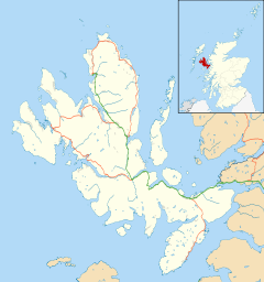
 Isleornsay
Isleornsay shown within the Isle of SkyeOS grid reference NG696125 Council area Highland Lieutenancy area Ross and Cromarty Country Scotland Sovereign state United Kingdom Post town ISLE OF SKYE Postcode district IV43 8 Dialling code 01471 Police Northern Fire Highlands and Islands Ambulance Scottish EU Parliament Scotland UK Parliament Ross, Skye and Lochaber Scottish Parliament Ross, Skye and Inverness West List of places: UK • Scotland • 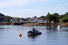 Isleornsay
Isleornsay (Scottish Gaelic: Eilean Iarmain) is a village lying off the main Armadale to Sleat road (the A851) on the Isle of Skye in Scotland. It overlooks, but is not upon, the island of Ornsay. The island itself shelters one of the best natural harbours in southern Skye. The location was exploited from the 18th century or earlier by the MacDonalds who owned this part of Skye.
There is a hotel in the village called The Isle Ornsay Hotel and a local company Pràban na Linne founded by Iain Noble which produces a vatted malt whisky called Poit Dhubh (literally the "Black Pot" or "Illicit Still" and two blends, Té Bheag nan Eilean ("small dram of the islands") and Mac na Mara (the "Son of the Sea").[1]
Contents
Emigration
Emigration from the Highlands and Islands was endemic in the 19th century and the company that ran the Isleornsay store, MacDonald and Elder, acted as emigration agents from the early 1800s. In 1822 they advertised that they were able to “to fit out transports for the conveyance of passengers from Inverness & the West Coast” of Scotland to the east coast of Canada. In the 1830s a programme of assisted passages to Australia from the Sleat peninsula was organised. The William Nicol sailed to Sydney from Isleornsay in July 1837 with 322 passengers including 70 families from Sleat. At the time it was reported that so many local people wished to emigrate that the ship could not accommodate all those who wanted to embark.[2]
Railway
In 1898, the proposed Hebridean Light Railway Company was to have terminated at a new ferry port at Isleornsay, but the line was never constructed.
See also
- Camuscross
References
- ^ "Visit Us at Eilean Iarmain" gaelicwhisky.com. Retrieved 7 Aug 2011.
- ^ "Emigration" Comunn Eachdraidh Shlèite/Sleat Local History Society. Retrieved 7 Aug 2011.
Skye / An t-Eilean Sgitheanach Main settlements Crofting townships
and settlementsAchachork · Aird of Sleat · Ardvasar · Armadale · Ashaig · Bernisdale · Bornesketaig · Boreraig · Borreraig · Borrodale · Borve · Bracadale · Breakish · Brogaig · Bualintur · Camastianavaig · Camuscross · Carbost, Loch Harport · Carbost, Portree · Claigan · Colbost · Drumfearn · Drynoch · Dunan · Duntulm · Edinbane · Elgol · Ellishadder · Eynort · Eyre · Fasach · Feorlig · Ferindonald · Fiskavaig · Flashader · Flodigarry · Galltrigill · Garafad · Geary · Gedintailor · Gillen · Glendale · Halistra · Harlosh · Heaste · Isleornsay · Kensaleyre · Kilbride · Kilmarie · Kilmore · Kilmuir · Kilvaxter · Kingsburgh · Kylerhea · Lealt · Lower Breakish · Luib · Milovaig · Ollach · Ose · Peinachorran · Portnalong · Ramasaig · Roag · Sconser · Skeabost · Sligachan · Staffin · Stein · Struan · Suladale · Talisker · Tarskavaig · Teangue · Torrin · Totaig · Tote · Treaslane · Trumpan · Uigshader · Ullinish · Upper BreakishMountains and hills Am Basteir · Beinn na Caillich · Blà Bheinn · Bruach na Frìthe · Clach Glas · Glamaig · Healabhal Bheag · Sgurr a' Ghreadaidh · Sgurr a' Mhadaidh · Sgurr Mhic Choinnich · Sgurr na Banachdich · Sgurr nan Gillean · Sgurr Dearg · Marsco · Quiraing/Meall na Suiramach · Sgurr Alasdair · The StorrHistory Armadale Castle · Battle of the Braes · Battle of the Spoiling Dyke · Caisteal Maol · Corriechatachan · Dùn Ringill · Dunvegan Castle · Fairy Flag · Flora MacDonald · Sir Rory Mor's Horn · Rubha an DùnainLocal culture Peninsulas Surrounding islands Ascrib Islands · Crowlin Islands · Eilean Bàn · Eilean Fladday · Eilean Mòr · Eilean Tigh · Eilean Trodday · Fladda-chùain · Harlosh Island · Isay · Lampay · Longay · Mingay · Oronsay · Pabay · Raasay · Scalpay · Rona · Soay · Staffin Island · Tarner Island · WiayCategories:- Populated places in Skye
- Highland geography stubs


Wikimedia Foundation. 2010.