Marsco

Marsco
Marsco
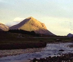
Elevation 736 m (2,415 ft)
Prominence 413 m (1,355 ft)
Parent peak Blaven
Listing Graham, Marilyn
Translation Seagull hill (Norse)
Pronunciation English: /ˈmɛərskoʊ/
Location
Location Red Cuillin, Skye, Scotland
Coordinates 57°14′58″N 6°08′04″W / 57.24932°N 6.13452°W / 57.24932; -6.13452Coordinates: 57°14′58″N 6°08′04″W / 57.24932°N 6.13452°W / 57.24932; -6.13452
Topo map OS Landranger 32
OS grid NG507252

Marsco is a peak in the Red Hills on the Scottish Isle of Skye. It lies on the east of Glen Sligachan, and may be climbed from the right-of-way through the glen from Sligachan to Loch Coruisk. Alternatively, it may also be reached from Coire nam Bruadaran on the western side. Marsco has magnificent views of the main Cuillin ridge as well as out to sea; many walkers reckon it is perhaps the finest of all the Grahams.

A photograph of Marsco and Glen Sligachan, taken by Richard Nutt, features on the cover of the second album by British synthpop band Orchestral Manoeuvres in the Dark (OMD), Organisation, released in October 1980.

The folk group Runrig released a song called Nightfall on Marsco on the album Recovery in 1981.

External links


Wikimedia Foundation. 2010.

Игры ⚽ Поможем решить контрольную работу

Look at other dictionaries:

  • Marsco — Tipo Estratovolcán Ubicación Gran Bretaña …   Wikipedia Español

  • Marsco glass products — Marsco Glass Products, LLC, is a manufacturing company in Chicago, Illinois, best known for its heat reflective coated glass products. Contents 1 History 2 Corporate Management 3 Products 4 …   Wikipedia

  • Cuillin — This article is about the Cuillin of Skye. See Rùm for the Cuillin of Rùm. Sgurr nan Gillean and the Pinnacle Ridge from Basteir gorge The Cuillin (Scottish Gaelic: An Cuilthionn or An Cuiltheann) are a range of rocky mountains located on the… …   Wikipedia

  • Cuillin — Saltar a navegación, búsqueda Sgurr nan Gillean y la Pinnacle Ridge desde la garganta Basteir …   Wikipedia Español

  • Cuillin Hills — p1f1p5 Cuillin Hills Höchster Gipfel Sgurr Alasdair (992 m ASL) Lage Schottland / Vereinigtes Königreich …   Deutsch Wikipedia

  • Raasay — Location …   Wikipedia

  • Dunvegan Castle — Dunvegan Castle, main entrance …   Wikipedia

  • Dunvegan — For other uses, see Dunvegan (disambiguation). Coordinates: 57°26′N 6°35′W / 57.44°N 6.58°W / 57.44; 6.58 …   Wikipedia

  • Crowlin Islands — Eilean Mòr, Crowlin Islands The Crowlin Islands (Scottish Gaelic: Na h Eileanan Cròlainneach) are a group of uninhabited islands in the Inner Hebrides of Scotland. They lie between Skye and the Applecross peninsula on the mainland. The individual …   Wikipedia

  • Duntulm — Coordinates: 57°41′N 6°20′W / 57.68°N 6.34°W / 57.68; 6.34 …   Wikipedia

Share the article and excerpts

Direct link
Do a right-click on the link above
and select “Copy Link”