Oat Lane

Oat Lane
Oat Lane

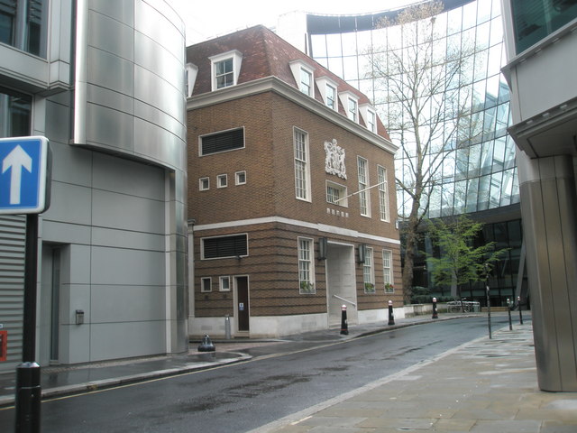
Oat Lane[1] is a short street in Bassishaw Ward, London.[2] First mentioned by Leake [3] in 1666[4], it runs from Noble Street[5] to Staining Lane[6]. The Great Hall of the Worshipful Company of Pewterers stands midway down it. In previous times a church St Mary Staining stood here[7] and a small garden still marks the spot[8].

Coordinates: 51°31′00″N 0°05′43″W / 51.516668°N 0.09539°W / 51.516668; -0.09539

References

  1. ^ In past times called Sheers Alley > "A Dictionary of London" Harben,H: London, Herbert Jenkins, 1918
  2. ^ Map of area
  3. ^ Details of Survey
  4. ^ British History on-line
  5. ^ Further details
  6. ^ ”Dodsley’s London and its environs described” London, R & J Dodsley 1761
  7. ^ Closed churches
  8. ^ City Gardens: Small Public Gardens

Wikimedia Foundation. 2010.

Игры ⚽ Нужно сделать НИР?

Look at other dictionaries:

  • Oat Lane —    East out of Noble Street, at No. 11, to 94 Wood Street, in Cripplegate and Aldersgate Wards (P.O. Directory).    First mention: Oate lane, 1666 (Leake).    In Rocque the eastern end is narrower and is called Sheers Alley, and See Bull s Head… …   Dictionary of London

  • Staining Lane —    North out of Gresham Street, at No.29, to Oat Lane, in Aldersgate Ward and Cripplegate Ward (P.O. Directory).    Earliest mention: Staninge lane, temp. Rich. I. (Anc. Deeds, A. 2124).    Other forms Stanigelane, 37 H. III. 1253 (Cal. P.R. H.… …   Dictionary of London

  • Gate Lane —    In parish of St. Mary Staynings, temp. Q. Elizabeth (Proc. in Chancery, II. 305).    Probably an error for Oat Lane, due to a confusion between the capital letters G and O …   Dictionary of London

  • St Mary Staining — Infobox church name = St Mary Staining fullname = color = imagesize = caption = Current photo of site landscape = denomination = Roman Catholic, Anglican diocese = parish = division = subdivision = founded date = founder = architect = style =… …   Wikipedia

  • Bull's Head Passage —    1) East out of Gracechurch Street at No. 81 (P.O. Directory). In Bishopsgate Ward Within. Leading into Skinner s Place (O.S.).    First mention: Lond. Guide, 1758.    2) West out of Wood Street at No. 94, opposite Love Lane, leading into Oat… …   Dictionary of London

  • Pump Court —    1) On the north side of Skinner Street at No.62 Snow Hill (Lockie, iS16). Removed for the formation of Holborn Viaduct and its approach.    2) North west out of Crutched Friars. In Aldgate Ward (Strype, 1720 Lond. Guide, 1758).    Site now… …   Dictionary of London

  • Nathaniel Holmes — For the stonecarver, see Nathaniel Holmes (stonecarver). Nathaniel Holmes or Homes[note 1] (1599–1678) was an English Independent theologian and preacher. He has been described as a “Puritan writer of great ability .[1] Contents 1 Life 2 Views …   Wikipedia

  • White Horse Court —    1) East out of Noble Street, in Aldersgate Ward, between Lillypot Lane and Oat Lane (Strype, 1720 and 1755).    The site seems to be occupied by Madock s Rents (q.v.) in O. and M. 1677. Site rebuilt as offices and business houses.    2) East… …   Dictionary of London

  • David Evelyn Nye — This article is about the British architect. For the American historian, see David Nye. David Evelyn Nye Blue plaque on the Berkhamsted Rex commemorating Nye s work …   Wikipedia

  • (St.) Alban's Court —    West out of Wood Street at No.91 with a passage south to Oat Lane (P.O. Directory). In Cripplegate Ward Within.    First mention: Horwood, 1799.    Named after the Church of St. Alban, Wood Street. Former name: Fryingpan Alley (q.v.) …   Dictionary of London

Share the article and excerpts

Direct link
Do a right-click on the link above
and select “Copy Link”