- N2 road (South Africa)
-
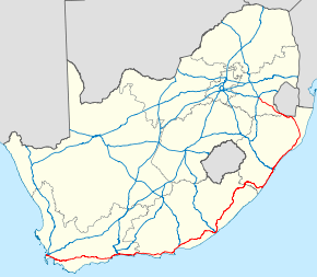
National Route N2
Route information Maintained by SANRAL, City of Cape Town Metropolitan Municipality[1] Major junctions West end: Buitengracht Street in Cape Town  N1 in Cape Town

 N9 / N12 near George
 N10 near Coega
 N6 in East London
 N3 in Durban
East end: 
 N11 / N17 in Ermelo
Location Major cities: Cape Town, George, Port Elizabeth, Grahamstown, King William's Town, East London, Mthatha, Durban, Richards Bay, Ermelo Highway system National Roads of South Africa
← N1N3 →The N2 is a National Route[2] in South Africa; it is the main highway along the Indian Ocean coast of the country. The N2 starts in Cape Town in the Western Cape and runs through the cities of Port Elizabeth and East London in the Eastern Cape and Durban in KwaZulu-Natal to end at Ermelo in Mpumalanga.
Contents
Route
Major towns and cities along the route of the N2 include Cape Town, Somerset West, Caledon, Swellendam, Mossel Bay, George, Knysna, Humansdorp, Port Elizabeth, Grahamstown, King William's Town, Bhisho, East London, Mthatha, Kokstad, Port Shepstone, Durban, KwaDukuza, Empangeni, Piet Retief, and Ermelo.
Western Cape
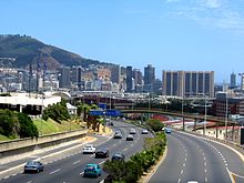 The N2, which is also known at this point as the Eastern Boulevard, as it enters the City Bowl of Cape Town.
The N2 begins in central Cape Town at the northern end of Buitengracht Street outside the entrance to the Victoria & Alfred Waterfront. The first section of the N2 is shared with the beginning of the N1; it is a four-lane elevated freeway that runs along a strip of land between the city centre and the Port of Cape Town. On the eastern edge of the city centre the two roads split, and the N2 turns south as Eastern Boulevard, crossing above the yards and approach tracks of Cape Town railway station.
The N2 descends to ground level in Woodstock before approaching the major interchange known as "Hospital Bend" because of its proximity to Groote Schuur Hospital. In this interchange, the N2 and the M3 merge to form a massive 10-lane freeway before diverging again. Because Hospital Bend is built on a steeply sloping curve, and lane-changing is often necessary to travel through the intersection, it was notorious for congestion and accidents, until it was upgraded between 2008 and 2010. [1][2]
After Hospital Bend the N2 turns east to travel across the Cape Flats as a 6-lane freeway to Somerset West; this section is known as Settler's Way. Along this route it crosses the M5, M7 and R300 freeways; it also travels just past the end of the main runway at Cape Town International Airport In Somerset West it is reduced to an undivided highway, passing through several intersections with traffic lights, which cause frequent congestion.
East of Somerset West the N2 climbs Sir Lowry's Pass to enter the Overberg region. It passes near the town of Grabouw on the Hottentots-Holland plateau before descending the Houwhoek Pass to Botrivier. After Botrivier it passes across the agricultural plains through the towns of Caledon, Riviersonderend, Swellendam and Riversdale to re-approach the coast at Mossel Bay, which marks the beginning of the Garden Route.
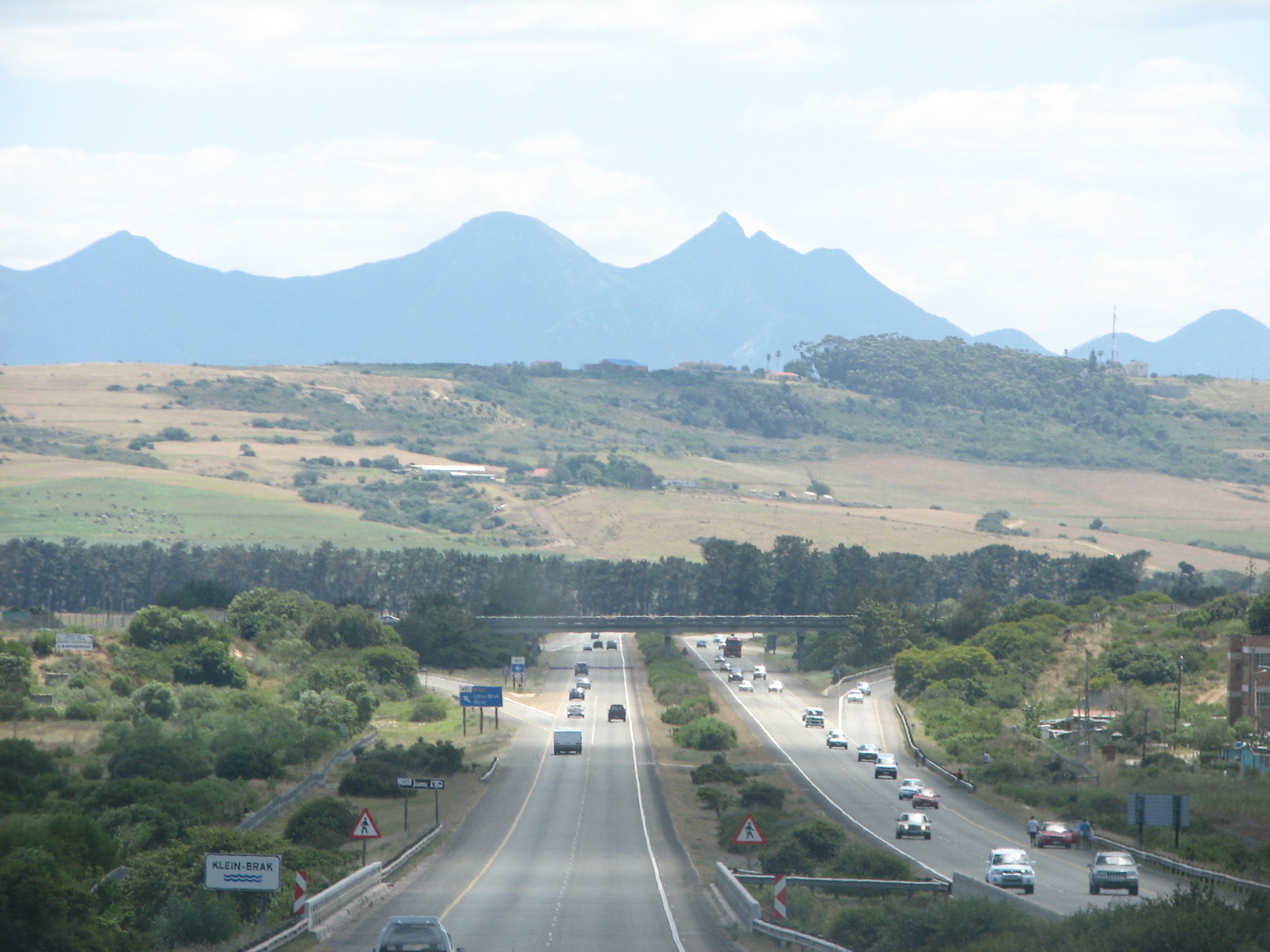
 N2 Freeway between George and Mossel Bay
Just west of Mossel Bay the N2 again becomes a divided freeway, and remains one as far as the intersection with the N9 just outside of George. From there it travels across Kaaiman's Pass (see below) to Wilderness and on to Knysna and Plettenberg Bay. After Plettenberg Bay a section of the road is tolled as the Tsitsikamma Toll Route, primarily because of the Bloukrans Bridge; an alternative route runs through Nature's Valley. The Bloukrans Bridge marks the border with the Eastern Cape.
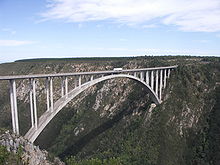 Bloukrans Bridge
Eastern Cape
In the Eastern Cape the N2 passes near Humansdorp and Jeffrey's Bay before becoming a four-lane divided freeway through the city of Port Elizabeth, ending at Coega. The N2 continues in a north-easterly direction from Port Elizabeth, moving away from the coast towards Grahamstown; en route the N10 splits from the N2, going northwards towards Middelburg. After Grahamstown the N2 passes through the former Ciskei; at King William's Town it turns back towards the coast, meeting it at East London. The N2 passes around East London on a bypass; it meets the N6 which runs northwards from East London towards Bloemfontein.
After East London the N2 turns again towards the interior, to avoid the difficult terrain of the Wild Coast. It passes through the former Transkei and its former capital Mthatha. Near Kokstad, KwaZulu-Natal the N2 crosses into the province of KwaZulu-Natal.
Kwa-Zulu Natal
From Kokstad the N2 turns again back towards the coast, meeting it at Port Shepstone. From Port Shepstone it runs as a freeway past the resort towns of the Natal South Coast, including Umzumbe, Hibberdene, Ifafa Beach, Scottburgh, Umkomaas and Amanzimtoti, before passing on a bypass around the city of Durban. At the Westville four-level bypass the N2 meets the N3 from Johannesburg.
After Durban the N2 continues as a freeway along the Natal North Coast past Umhlanga Rocks, Ballito and Tongaat, with the freeway ending at KwaDukuza. It passes the port of Richard's Bay and turns north, moving away from the coast into the heart of Zululand. It passes close to the Greater St Lucia Wetland Park and the Hluhluwe-Umfolozi Game Reserve. It approaches the border with Swaziland near to the border post of Golela, and turns westwards, running just south of the border through the town of Pongola before entering Mpumalanga province.
Mpumalanga
In Mpumalanga the N2 continues close to the Swazi border to the town of Piet Retief, from which it travels north-west to end in the town of Ermelo. Ermelo is connected by the N17 to Johannesburg and Mbabane, and by the N11 to Mokopane and Ladysmith.
Disruption to route
Heavy rains triggered a mud-slide on the Kaaiman's pass section of the N2 between George and Wilderness. This caused the road to be temporarily closed from 26 August 2006. As a result of the slide a section of roadway sagged and large cracks appeared on the road surface. After an inspection by a team of engineers a single lane was reopened on 29 August for vehicles with a gross mass of under 5000 kg.
An alternative route following the Saasveld road was put into use, but this road only allows for a single lane of traffic and light vehicles. Heavy vehicles have to take an alternative route via the R62 and Langkloof pass effectively lengthening the distance from George to Wilderness from 11 km to over 600 km (news24.com story). The road has since reopened but major repairs are being done.
Traffic on the N2 has also been disrupted on numerous occasions because of protests. On 10 September 2007, residents of Joe Slovo Informal Settlement blockaded the N2 Freeway in Cape Town near Langa. Police responded with rubber bullets injuring over 30 residents.[3][4] On 4 December 2008, a few thousand residents of eMachambini, between KwaDukuza and Richards Bay in KZN, blockaded the N2 Freeway in protest against the proposed AmaZulu World Themepark. Police opened fire and injured about 23 residents and arrest about 10.[5]
References
- ^ N2/Settlers Freeway (“Hospital Bend”)
- ^ routes.co.za - N-routes
- ^ "Cape Town: Police wade in on Joe Slovo shackdwellers blockade". labournet. http://www.labournet.net/world/0709/cape1.html.
- ^ "N2 Gateway and the Joe Slovo informal settlement: the new Crossroads?". Abahlali. http://www.abahlali.org/node/2437.
- ^ "Cops break up protest over KZN development". Mail & Guardian. http://www.mg.co.za/article/2008-12-05-cops-break-up-protest-over-kzn-development.
See also
- National Roads in South Africa
- The N2 Gateway Housing Project along the N2 freeway in Cape Town
National (N) Routes in South Africa 

Highways in the Western Cape 
National roads Major regional roads R27 · R43 · R44 · R45 · R46 · R60 · R61 · R62 · R63Minor regional roads R101 · R102 · R300 · R301 · R302 · R303 · R304 · R305 · R307 · R310 · R311 · R312 · R315 · R316 · R317 · R318 · R319 · R320 · R321 · R322 · R323 · R324 · R326 · R327 · R328 · R339 · R340 · R341 · R353 · R354 · R355 · R356 · R358 · R362 · R363 · R364 · R365 · R366 · R381 · R399 · R404 · R406 · R407Freeways in Cape Town 
Existing Proposed Categories:- N2 road (South Africa)
- National Roads in South Africa
- Roads in Cape Town
- Transport in Durban


Wikimedia Foundation. 2010.