- Mary Point Estate
-
Mary Point Estate
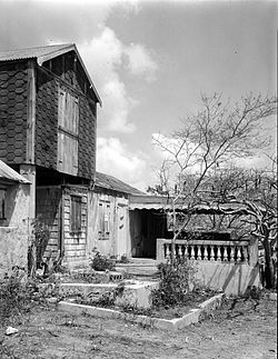 Great House at Mary Point Estate
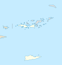

Coordinates: 18°22′4″N 64°44′31″W / 18.36778°N 64.74194°WCoordinates: 18°22′4″N 64°44′31″W / 18.36778°N 64.74194°W Architectural style: No Style Listed MPS: Virgin Islands National Park MRA (AD) NRHP Reference#: 78000272[1] Added to NRHP: May 22, 1978 Mary Point Estate is a historic property located on the north coast of Saint John, United States Virgin Islands on Mary's Point. The plantation was added to the U.S. National Register of Historic Places on May 22, 1978.[1]
History
The land on which Mary Point Estate sits was originally held by Danish West India and Guinea Company officials during the early years of Danish settlement. Not being prime land for planting, the land was held until new settlers needed property. The van Stell family was the first controlling landholding on Mary's Point.[2]
In the aftermath of the 1733 slave insurrection on St. John, Franz Claasen was deeded the Mary's Point estate for alerting the family of the rebellion and assisting in their escape to St. Thomas, a nearby island. Franz Claasen's land deed was recorded on August 20, 1738 by Jacob van Stell. Claasen was the first "Free Colored" landowner on St. John.[2]
Augustus Kragh and the Grancis family were owners of the Mary Point Estate during the late 18th century. Hans Hendrik Berg, a governor and president of St. John and St. Thomas, was an owner of the Mary Point Estate during the 19th century. During this time an L-shaped factory and the one-story Great House were constructed on the property. In addition to the Great House, a servant's quarters, farm building, and cemetery remain.[3]
References
- ^ a b "National Register Information System". National Register of Historic Places. National Park Service. 2008-04-15. http://nrhp.focus.nps.gov/natreg/docs/All_Data.html.
- ^ a b David Knight (January 2007). "Mary's Point Hike". St. John Historical Society Newsletter. St. John Historical Society. http://www.stjohnhistoricalsociety.org/Articles/MarysPoint.htm?limited=1. Retrieved 2008-07-21.
- ^ "Mary Point Great House and Factory". National Park Service. http://www.nps.gov/history/nR/travel/prvi/pr43.htm. Retrieved 2008-07-24.
National Register of Historic Places in Virgin Islands National Park Historic districts Annaberg Historic District | Hassel Island | Hermitage Plantation Historic District | Jossie Gut Historic District | Liever Marches Bay Historic District | More Hill Historic District
NRHP properties Brown Bay Plantation Historic District | Catherineberg-Jockumsdahl-Herman Farm | Cinnamon Bay Plantation | Dennis Bay Historic District | Lameshur Plantation | Lind Point Fort | Mary Point Estate | Petroglyph Site
See also: National Register of Historic Places listings in Virgin Islands National Park U.S. National Register of Historic Places Topics Lists by states Alabama • Alaska • Arizona • Arkansas • California • Colorado • Connecticut • Delaware • Florida • Georgia • Hawaii • Idaho • Illinois • Indiana • Iowa • Kansas • Kentucky • Louisiana • Maine • Maryland • Massachusetts • Michigan • Minnesota • Mississippi • Missouri • Montana • Nebraska • Nevada • New Hampshire • New Jersey • New Mexico • New York • North Carolina • North Dakota • Ohio • Oklahoma • Oregon • Pennsylvania • Rhode Island • South Carolina • South Dakota • Tennessee • Texas • Utah • Vermont • Virginia • Washington • West Virginia • Wisconsin • WyomingLists by territories Lists by associated states Other  Category:National Register of Historic Places •
  Portal:National Register of Historic PlacesCategories:
- Historic districts in the United States Virgin Islands
- Buildings and structures in the United States Virgin Islands
- National Register of Historic Places in the United States Virgin Islands
- Virgin Islands National Park
- National Register of Historic Places stubs
- United States Virgin Islands stubs


Wikimedia Foundation. 2010.