- Cinnamon Bay Plantation
-
Cinnamon Bay Plantation
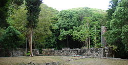 Cinnamon Bay Plantation.
Nearest city: Cruz Bay, Virgin Islands Coordinates: 18°21′14″N 64°45′18″W / 18.35389°N 64.755°WCoordinates: 18°21′14″N 64°45′18″W / 18.35389°N 64.755°W Area: 13 acres (5.3 ha) Governing body: National Park Service MPS: Virgin Islands National Park MRA (AD) NRHP Reference#: 78000269[1] Added to NRHP: July 11, 1978 Cinnamon Bay Plantation is an approximately 300-acre (1.2 km2) property situated on the north central coast of Saint John in the United States Virgin Islands adjacent to Cinnamon Bay.[2] The land, part of Virgin Islands National Park, was added to the United States National Register of Historic Places on July 11, 1978.[1] Archaeological excavations of the land document ceremonial activity of the Taínos, as well as historic remains of plantation ruins.[3]
Contents
History
Early inhabitants
Archaeological evidence shows that the first inhabitants of the Virgin Islands were Ortoiroid people. The Arawaks migrated to the area over a period of many centuries and engaged in the first agriculture on the land.[2][4] Archaeological excavations confirm a Classic Taino culture at Cinnamon Bay.[5]
Plantation era
Starting in the 1680s, prior to any formal colonization, the land along the shoreline of the north central coast of Saint John was occupied for decades by settlers with diverse nationalities. The property was used for maritime activities and cotton production.[6] The Danish claimed Saint John on March 25, 1718 and the area along the north central coast from Caneel Bay to Cinnamon Bay was occupied by nine private land owner. The Danish established large plantations worked by slaves brought from African.[2]
Daniel Jansen and his wife Adriana Delicat were the first land owners to acquire a formal Danish deed for property at Cinnamon Bay. Approximate to Jenson's purchase in 1718, a coastal parcel of land was purchased by William Gandy in 1722, and was later bought by Peter Durloo in 1728. Durloo was the husband of Daniel Jansen's daughter, Elizabeth. Durloo's newly acquired coastal land abutted Jensen's property to the north. In 1719, Pieter de Buyck purchased property along the north central coast of the island, east of the Gandy-Durloo land. After de Buyck's death in 1728, the land became the property of Abraham Beaudewyn. The 1936 tax records show that Jasper Jansen, Daniel and Adriana Jansen's eldest son, owned the de Buyck-Beaudewyn land. Despite the short tenure of de Buyck, this locale still carries his name, Peter Bay. These three parcels of land; the Jansen, Gandy-Durloo, and de Buyck-Beaudewyn properties, became the consolidated estate later known as Cinnamon Bay Plantation.[7]
List of new owners of the consolidated property:
- 18th century
- 1739 Adriana Jansen and Jasper Jansen
- 1755 John Hobby (married Jasper Jansen's widow)
- 1760 Commandant Harrien Felchenhauer
- 1765 Madam Adriana Bödker
- 1770 Mathias Bowe
- 1775 Wood and Guyle for Patrik Mc Donnel
- 1776 Michael Shoy
- 1780 Michael Shoy's heirs
- 1784 Lachlan Mc Lachlan ( married to Mary Shoy)
- 1785 Johannes Dam (married to Mary Shoy)
- 1790 Johannes Dam's heirs
- 1795 Hans D. Cronenberg (married to Mary Shoy)
- 19th century
- 1805 Mary Cronenberg
- 1823 Mary Lindberg
- 1834 N. S. Hjardemaal and Andersen
- 1836 N. S. Hjardemaal
- 1845 N. S. Hjardemaal and C. A Woldsen
- 1847 Clement Skelton, Thomas Ivinson, and William Dawson
- 1857 R. F. Barner
- 1858 Abraham Chalwell Hill
- 1863 John William Weinmar
- 1867 Carl Alexander Lindqvist
- 1884 Margaret Lindqvist
- 1894 John Emanuel Lindqvist, Caroline Amelia Lindqvist, Marie Eliza Lindqvist, and Georgianne Adriane Lindqvist
- 20th century
- 1903 Danish West Indies Plantation Company
1733 slave insurrection
During the 1733 slave insurrection on St. John, slaves loyal to the Jensen family held off the rebel slaves long enough for the Jansen's to escape, but could not prevent "the property's dwelling house, storage building, and boiling house from being looted and burned, nor could they prevent the Jansen cane fields from being set ablaze",[7]
20th century history
In 1913, Cinnamon Bay was bought by a Danish company and the land was used for breeding and raising of cattle.
In 1955, Cinnamon Bay was sold to Jackson Hole Preserve, Incorporated and in 1956 donated to Virgin Islands National Park.
Sugar plantation
The 1805 tax rolls show that Cinnamon Bay plantation had 105 acres (0.42 km2) planted in sugarcane, 48 acres (190,000 m2) in provision crops, and 147 acres (0.59 km2) unused or in bush.[8]
Virgin Islands National Park
The land was donated to the United States National Park Service in 1956 by Laurence Rockefeller.
References
- ^ a b "National Register Information System". National Register of Historic Places. National Park Service. 2009-03-13. http://nrhp.focus.nps.gov/natreg/docs/All_Data.html.
- ^ a b c "Introduction:A Documentary History of the Cinnamon Bay Plantation 1718–1917". Cinnamon Bay Archaeological Project. 1999. http://www.friendsvinp.org/archive/Cinnamon/cinmer3exec.htm.
- ^ Archeology at Cinnamon Bay
- ^ Investigations at Cinnamon Bay
- ^ Understanding The Petroglyphs.
- ^ "The Shoreline Settlement at Cinnamon Bay, St. John, U.S.V.I.: A Small Estate Established Before formal Colonization and Burned During the Slave Rebellion of 1733" (a paper presented by Dr. Doug Armstrong at the 2003 Conference of the Society for Historical Archaeology.)
- ^ a b "Part I:A Documentary History of the Cinnamon Bay Plantation 1718–1917". Cinnamon Bay Archaeological Project. 1999. http://www.friendsvinp.org/archive/Cinnamon/cinmer31.htm.
- ^ "Part III:A Documentary History of the Cinnamon Bay Plantation 1718–1917". Cinnamon Bay Archaeological Project. 1999. http://www.friendsvinp.org/archive/Cinnamon/cinmer31.htm.
National Register of Historic Places in Virgin Islands National Park Historic districts Annaberg Historic District | Hassel Island | Hermitage Plantation Historic District | Jossie Gut Historic District | Liever Marches Bay Historic District | More Hill Historic District
NRHP properties Brown Bay Plantation Historic District | Catherineberg-Jockumsdahl-Herman Farm | Cinnamon Bay Plantation | Dennis Bay Historic District | Lameshur Plantation | Lind Point Fort | Mary Point Estate | Petroglyph Site
See also: National Register of Historic Places listings in Virgin Islands National Park U.S. National Register of Historic Places Topics Lists by states Alabama • Alaska • Arizona • Arkansas • California • Colorado • Connecticut • Delaware • Florida • Georgia • Hawaii • Idaho • Illinois • Indiana • Iowa • Kansas • Kentucky • Louisiana • Maine • Maryland • Massachusetts • Michigan • Minnesota • Mississippi • Missouri • Montana • Nebraska • Nevada • New Hampshire • New Jersey • New Mexico • New York • North Carolina • North Dakota • Ohio • Oklahoma • Oregon • Pennsylvania • Rhode Island • South Carolina • South Dakota • Tennessee • Texas • Utah • Vermont • Virginia • Washington • West Virginia • Wisconsin • WyomingLists by territories Lists by associated states Other  Category:National Register of Historic Places •
  Portal:National Register of Historic PlacesCategories:
- Historic districts in the United States Virgin Islands
- National Register of Historic Places in the United States Virgin Islands
- Virgin Islands National Park
- 18th century
Wikimedia Foundation. 2010.