- Deir 'Ammar
-
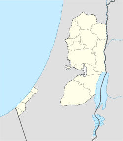
Deir 'Ammar Other transcription(s) - Arabic دير عمار Location of Deir 'Ammar within the Palestinian territories Coordinates: 31°58′00.33″N 35°06′06.76″E / 31.9667583°N 35.1018778°ECoordinates: 31°58′00.33″N 35°06′06.76″E / 31.9667583°N 35.1018778°E Governorate Ramallah & al-Bireh Government - Type Village Council Population (2006) - Jurisdiction 2,414 Deir 'Ammar (Arabic: دير عمار) is a Palestinian town in the Ramallah and al-Bireh Governorate, located 17 kilometers Northwest of Ramallah in the northern West Bank. According to the Palestinian Central Bureau of Statistics (PCBS), the town had a population of 2,414 inhabitants in mid-year 2006.[1]
Footnotes
External links
Ramallah and al-Bireh Governorate Cities 

Municipalities Bani Zeid · Bani Zeid al-Sharqiya · Beit Liqya · Bir Zeit · Deir Dibwan · al-Mazra'a ash-Sharqiya · Ni'lin · Silwad · Sinjil · Turmus Ayya · al-Zaitounah (Abu Shukhaidem · al-Mazra'a al-Qibliya) · al-Ittihad (Beitillu · Deir 'Ammar · Jammala) · TaybehVillage councils Aboud · Abu Qash · Abwein · Ajjul · 'Atara · Beitin · Beit Ur al-Fauqa · Beit Ur al-Tahta · Bil'in · Beit Sira · Budrus · Burham · Burqa · Deir Ibzi · Deir Jarir · Deir Abu Mash'al · Deir Nidham · Deir Qaddis · Deir as-Sudan · Dura al-Qar' · Ein 'Arik · Ein Qiniya · Ein Siniya · Ein Yabrud · al-Janiya · Jifna · Kafr Ein · Kafr Malik · Kafr Ni'ma · Kharbatha al-Misbah · Kharbatha Bani Harith · Khirbet Abu Falah · Kobar · al-Lubban al-Gharbi · al-Midya · al-Mughayyir · Nabi Salih · Qarawat Bani Zeid · Qibya · Rammun · Rantis · Ras Karkar · Saffa · Shuqba · Surda · YabrudRefugee camps Categories:- Ramallah and al-Bireh Governorate
- Palestine geography stubs
- Villages in the West Bank
Wikimedia Foundation. 2010.

