- Bani Zeid al-Sharqiya
-
For the nearby Palestinian towns, see Bani Zeid and Qarawat Bani Zeid.
Bani Zeid al-Sharqiya Other transcription(s) - Arabic بني زيد الشرقية - Also spelled Bani Zeid East (official)
Bani Zayd ash-Sharqiyya (unofficial)Location of Bani Zeid al-Sharqiya within the Palestinian territories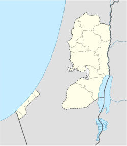
 Bani Zeid al-Sharqiya
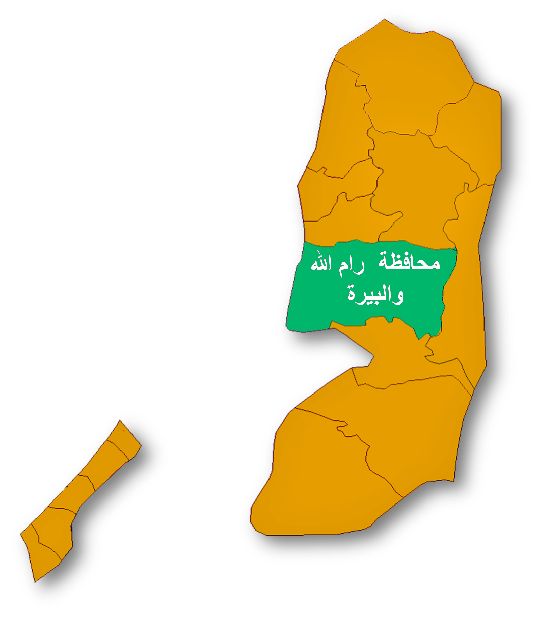
Coordinates: 32°02′41.80″N 35°10′10.65″E / 32.044944°N 35.169625°ECoordinates: 32°02′41.80″N 35°10′10.65″E / 32.044944°N 35.169625°E Governorate Ramallah & al-Bireh Government - Type Municipality - Head of Municipality Abd al-Rahman al-Nubani Population (2007) - Jurisdiction 5,083 Name meaning "Eastern Bani Zeid" Bani Zeid al-Sharqiya (Arabic: بني زيد الشرقية) is a Palestinian town in the northern West Bank, located north of Ramallah in the Ramallah and al-Bireh Governorate. It was formed as a result of a merger of the villages of 'Arura, Mazari al-Nubani, and Abwein, although the latter separated from the municipality.[1] Bani Zeid al-Sharqiya is 3 kilometers (1.9 mi) north of Ajjul and other nearby localities include Deir as-Sudan to the southeast, Kafr Ein to the east, and Abwein to the southwest.[2]
Contents
History
Main article: Bani ZeidBoth Arura and Mazari al-Nubani were part of the Bani Zeid subdistrict in the Sanjak of Jerusalem. The two villages produced a combined 99 qintars of olive oil, the chief agricultural product of the Bani Zeid,[3] and adult males in were taxed a combined 649 akçe.[4]
'Arura
'Arura (Arabic: عاروره, ‘Arūrā) 32°02′29.82″N 35°10′17.51″E / 32.0416167°N 35.1715306°E is situated 500 meters (1,600 ft) above sea level.[5] In 1945, its total land area was 10,978 dunams, of which was 26 were built-up areas and 2,550 used for olive groves.[6] Near, and within the village are three shrines dedicated to Sheikh Radwan, Sheikh Ahmad, and al-Khidr. Al-Khidr's shrine, in the center of the village, has no relation to al-Khidr, and his simply dedicated to a holy man with the same name. Al-Khidr or Saint George is revered throughout Palestine in several towns and villages. Sheikh Ahmad's shrine is to the west of 'Arura.[7]
The Shrine of Sheikh Radwan bin 'Ulayl al-Arsufi, built during the Ayyubid rule of interior Palestine, is located to the southwest of the village situated on a hill roughly 600 meters (2,000 ft) above sea level. Not much is known about Radwan, except that his family was from Arsuf and he was an important man in the area that died in Egypt and was transferred to 'Arura for his burial. Muslim scholars suggested that Sheikh Radwan was from the 'Ulayl family. An Arabic inscription written in typical rural Ayyubid style, on the shrine's surface reads that he was transferred to "blessed Syria" (in early Islamic times, Palestine was a province of Syria). A mosque was constructed adjacent to the shrine.[7]
In the 1922 British survey of Palestine, 'Arura had 426 inhabitants rising to 566 in the 1931 census.[5] There were 660 residents in 1945, according to Sami Hadawi's land and population survey.[6] There was a sharp decrease in the population from 1961 to 1982, caused by nearly half of 'Arura's inhabitants fleeing the village in the 1967 Six-Day War.[5] In 1997, 'Arura had a population of 2,087, of which 30 residents (1.4%) were Palestinian refugees.[8] The gender make-up was 1,069 males and 1,018 females.[8] According to the Palestinian Central Bureau of Statistics, it had a population of approximately 2,967 in mid-year 2006.[9]
Mazari al-Nubani
Mazari al-Nubani (Arabic: مزارع النوباني) 32°02′57.29″N 35°09′57.25″E / 32.0492472°N 35.1659028°E is situated along the same height as 'Arura. Mazari al-Nubani has been identified as the possible site of a Crusader church.[10] In the 1922 British survey of Palestine, Mazari al-Nubani had 611 inhabitants rising to 864 in the 1931 census.[11] There were 1,090 residents in 1945, according to Sami Hadawi's land and population survey.[6] According to the Palestinian Central Bureau of Statistics (PCBS), the town had a population of approximately 2,510 inhabitants in mid-year 2006.[9]
Local government
The municipality was formed after a merger of 'Arura, Mazari al-Nubani, and Abwein prior to the Palestinian municipal elections in 2005. During the elections, Fatima Taher Sihweil from Abwein won and the municipality fell apart with only 'Arura and Mazari al-Nubani remaining.
References
- ^ [1] Ministry of Local Government of the Palestinian National Authority. (Arabic)
- ^ Satellite view of 'Arura
- ^ Singer, 1994, p.78.
- ^ Singer, 1994, p.59.
- ^ a b c Welcome To 'Arura Palestine Remembered.
- ^ a b c Hadawi, 1970 p.64.
- ^ a b Sharon, 1997, p.121 -p.123.
- ^ a b Palestinian Population by Locality and Refugee Status Palestinian Central Bureau of Statistics (PCBS).
- ^ a b Projected Mid -Year Population for Ramallah & Al Bireh Governorate by Locality 2004- 2006 Palestinian Central Bureau of Statistics (PCBS).
- ^ Pringle, 1993, pp.29-30.
- ^ Welcome To Mazari al-Nubani Palestine Remembered.
Bibliography
- Hadawi, Sami (1970), Village Statistics of 1945: A Classification of Land and Area ownership in Palestine, Palestine Liberation Organization Research Center, http://www.palestineremembered.com/Articles/General-2/Story3150.html
- Pringle, Denys (1993), The Churches of the Crusader Kingdom of Jerusalem: A Corpus, Cambridge University Press, ISBN 0521390370, http://books.google.com/?id=2Y0tA0xLzwEC&pg=RA1-PA3&lpg=RA1-PA3&dq=Lajjun+village
- Tamārī, Salīm (2008), Mountain Against the Sea: Essays on Palestinian Society and Culture, University of California Press, ISBN 9780520251298, http://books.google.com/?id=tfz6YsgKGKAC
- Sharon, Moshe (1997), Corpus Inscriptionum Arabicarum Palaestinae, Vol. I, A, BRILL, ISBN 9004108335, http://books.google.com/?id=j1rSzWgHMjoC
- Singer, Amy (1994), Palestinian Peasants and Ottoman Officials: Rural Administration Around Sixteenth-Century Jerusalem, Cambridge University Press, ISBN 0521476798, http://books.google.com/?id=mrsAw_mk1d0C&pg=PA76&dq=Bani+Zayd+Ottoman
Ramallah and al-Bireh Governorate Cities 

Municipalities Bani Zeid · Bani Zeid al-Sharqiya · Beit Liqya · Bir Zeit · Deir Dibwan · al-Mazra'a ash-Sharqiya · Ni'lin · Silwad · Sinjil · Turmus Ayya · al-Zaitounah (Abu Shukhaidem · al-Mazra'a al-Qibliya) · al-Ittihad (Beitillu · Deir 'Ammar · Jammala) · TaybehVillage councils Aboud · Abu Qash · Abwein · Ajjul · 'Atara · Beitin · Beit Ur al-Fauqa · Beit Ur al-Tahta · Bil'in · Beit Sira · Budrus · Burham · Burqa · Deir Ibzi · Deir Jarir · Deir Abu Mash'al · Deir Nidham · Deir Qaddis · Deir as-Sudan · Dura al-Qar' · Ein 'Arik · Ein Qiniya · Ein Siniya · Ein Yabrud · al-Janiya · Jifna · Kafr Ein · Kafr Malik · Kafr Ni'ma · Kharbatha al-Misbah · Kharbatha Bani Harith · Khirbet Abu Falah · Kobar · al-Lubban al-Gharbi · al-Midya · al-Mughayyir · Nabi Salih · Qarawat Bani Zeid · Qibya · Rammun · Rantis · Ras Karkar · Saffa · Shuqba · Surda · YabrudRefugee camps Categories:- Ramallah and al-Bireh Governorate
- Towns in the West Bank

Wikimedia Foundation. 2010.