- Mount Clare (Maryland)
-
For the historic railroad complex, see Mount Clare Shops.Mount Clare
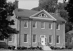

Location: Baltimore, Maryland Coordinates: 39°16′44″N 76°38′37″W / 39.27889°N 76.64361°WCoordinates: 39°16′44″N 76°38′37″W / 39.27889°N 76.64361°W Built: 1763 Architect: Unknown Architectural style: Georgian Governing body: Local NRHP Reference#: 70000860 Significant dates Added to NRHP: April 15, 1970[1] Designated NHL: April 15, 1970[2] Mount Clare is the oldest Colonial-era structure in Baltimore, Maryland, United States. The Georgian style plantation house exhibits a somewhat altered five-part plan.[3] It was built on a Carroll family plantation beginning in 1763 by barrister Charles Carroll, a descendant of the last Gaelic Lords of Éile in Ireland and a distant relative of Charles Carroll of Carrollton, signer of the Declaration of Independence.
The first building on the property was built by John Henry Carroll, barrister Charles Carroll's brother, in 1754, and was probably eventually incorporated as a portion of the larger house. Charles inherited the property on John's death and began construction between 1757 and 1760. Charles built the present 2-1/2 story Georgian style central block, incorporating John's kitchen and flanking it with a wash house and an orangery. In 1768 Charles added the projecting bay and Palladian window that dominate the entry facade today. The kitchen wing was enlarged and an office wing was added for balance, resulting in a symmetrical nine-part elevation.[4] The house was completed about 1767.[5]
After Charles' death in 1783 his widow made further changes, connecting outbuildings and adding a greenhouse to the orangery and expanding the laundry, resulting in a complex about 360 feet long. These additions, along with other alterations, were in the more current Federal style.[4]
The mansion left the family in 1840, and the house's flanking wings were demolished. During the American Civil War it was used as a headquarters by Union forces. After a period as a beer garden, the house and 70 acres (28 ha) were purchased by the city of Baltimore as a park.[5]
The house features a portico on the front facade with a projecting bay above. The upper bay contains a Palladian window. The city of Baltimore built Palladian pavilions connected by hyphens on either side in 1910 as public toilets,[5] but these do not reflect historical construction.[6] They have since been converted to a library and a colonial-era kitchen exhibit.[5] The house has been maintained by the National Society of Colonial Dames in Maryland since 1917.[6]
References
- ^ "National Register Information System". National Register of Historic Places. National Park Service. 2008-04-15. http://nrhp.focus.nps.gov/natreg/docs/All_Data.html.
- ^ "Mount Clare". National Historic Landmark summary listing. National Park Service. http://tps.cr.nps.gov/nhl/detail.cfm?ResourceId=1034&ResourceType=Building. Retrieved 2008-06-17.
- ^ "Maryland Historical Trust". National Register of Historic Places: Properties in Baltimore City. Maryland Historical Trust. 2008-06-10. http://www.mht.maryland.gov/nr/NRDetail.aspx?HDID=41&FROM=NRNHLList.aspx.
- ^ a b Dorsey, John; Dilts, James D. (1981). A Guide to Baltimore Architecture (Second ed.). Centreville, Maryland: Tidewater Publishes. pp. 140–142. ISBN 0-87033-272-4.
- ^ a b c d National Historic Landmark Nomination: Mount ClarePDF (201 KB). National Park Service. December 19, 1969.
- ^ a b "Mount Clare". Baltimore:A National Register of Historic Places Travel Itinerary. National Park Service. http://www.nps.gov/nr//travel/baltimore/b2.htm. Retrieved 2009-03-17.
External links
- Mount Clare Museum House - official site
- Mount Clare, National Park Service, Baltimore:A National Register of Historic Places Travel Itinerary
- Mount Clare, Baltimore City, including undated photo, at Maryland Historical Trust
- Mount Clare, Bayard & South Monroe Streets, Carroll Park, Baltimore, Independent City, MD: 7 photos, 18 data pages, at Historic American Building Survey
U.S. National Register of Historic Places Topics Lists by states Alabama • Alaska • Arizona • Arkansas • California • Colorado • Connecticut • Delaware • Florida • Georgia • Hawaii • Idaho • Illinois • Indiana • Iowa • Kansas • Kentucky • Louisiana • Maine • Maryland • Massachusetts • Michigan • Minnesota • Mississippi • Missouri • Montana • Nebraska • Nevada • New Hampshire • New Jersey • New Mexico • New York • North Carolina • North Dakota • Ohio • Oklahoma • Oregon • Pennsylvania • Rhode Island • South Carolina • South Dakota • Tennessee • Texas • Utah • Vermont • Virginia • Washington • West Virginia • Wisconsin • WyomingLists by territories Lists by associated states Other  Category:National Register of Historic Places •
  Portal:National Register of Historic PlacesCategories:
- National Historic Landmarks in Maryland
- Houses on the National Register of Historic Places in Baltimore, Maryland
- Museums in Baltimore, Maryland
- Buildings and structures completed in 1767
- Georgian architecture in Maryland
- Historic house museums in Maryland
- Plantations in Maryland
- Carroll family residences
- Houses in Baltimore, Maryland


Wikimedia Foundation. 2010.