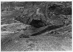
- Danger Cave
-
Danger Cave

Location: Tooele County, Utah, USA Nearest city: Wendover, Utah Governing body: State NRHP Reference#: 66000741 Significant dates Added to NRHP: October 15, 1966[1] Designated NHL: January 20, 1961[2] Danger Cave is a North American Archaeological site located in the Bonneville Basin of western Utah around the Great Salt Lakes region, that features artifacts of the Desert Culture from ca. 9500 BCE until ca. 500 CE. Through carbon-14 dating, it has been determined that there is very little evidence of human life in the Danger Cave area in 11,000 BP, but there is much evidence of human life by 9,000 BP. The cave contains evidence of nearly 11,000 years of occupation in the high desert.[3]
Danger cave was first investigated in the 1930s by Elmer Smith, and excavated in the 1950s under the supervision of Jesse D. Jennings, professor at the University of Utah. Jennings' work at the site was considered ground-breaking due to his exacting standards in excavation and data analysis. Though Jenning's findings eventually gained widespread acceptance, his publications garnered both criticism and support at first. Relating the archaeological evidence from Danger Cave to an ethnographic model, Jennings framed a view of the little known Great Basin Desert culture which was unknown at the time. Jenning's discoveries at Danger Cave were supporting evidence for the Clovis site and the antiquity of humans in the Americas at the time. Renewed investigations at Danger Cave were conducted in the 1980s by a team from the Desert Research Institute led by David Rhode and David Madsen. They emphasized the recovery of archaeobotanical remains which demonstrated that pine nuts were a substantial part of the residents' diet.
The extremely dry cave had created an ideal storage condition that preserved a variety of fascinating artifacts from beetle wings to textiles and human paleofeces. They also found leather scraps, pieces of string, nets of twine, coarse fabric, basket fragments, and bone and wood tools such as knives, weapons, and millstones. Amazingly, the excavation also yielded identifiable fragments of 68 plant species that still grow today within ten miles of the cave as well as the bones of many species of animals.[4] While the preservation of the cave is excellent, the stratigraphy of the cave is muddled. Prehistoric occupations throughout the history of the caves has led to repeatedly modified ground surfaces. Occupants would dig into the previous layers for storage pits and create suitable living spaces.
The data collected from the cave suggested that the Desert Culture had a sparse population, with small social units numbering no more than 25 to 30 people. The focus on survival prevented the inhabitants from building permanent structures, developing complicated rituals, or amassing extensive personal property. The Desert Culture persisted for thousands of years despite the hardships they faced, and eventually became the basis for other early Utah cultures such as the Fremont.
The dry condition of the cave helped to preserve artifacts. Remnants discovered in the cave include those of nets, textiles, baskets, tools, and weapons. It seems that groups that lived in the cave contained no more than 30 people. Evidence suggests that owls, coyotes, and woodrats also inhabited the cave.
It was declared a National Historic Landmark in 1961.[2][5]
References
- ^ "National Register Information System". National Register of Historic Places. National Park Service. 2007-01-23. http://nrhp.focus.nps.gov/natreg/docs/All_Data.html.
- ^ a b "Danger Cave". National Historic Landmark summary listing. National Park Service. http://tps.cr.nps.gov/nhl/detail.cfm?ResourceId=556&ResourceType=Site. Retrieved 2008-04-01.
- ^ Hirst, Kris. "Danger Cave (USA)". About.com Archaeology. http://archaeology.about.com/od/dterms/g/dangercave.htm. Retrieved 28 March 2011.
- ^ "Danger Cave Near Wendover Provided Clues to Ancient Utah Dwellers". Utah History to Go. Utah.gov. http://historytogo.utah.gov/utah_chapters/american_indians/dangercaveprovidedcluestoancientutahdwellers.html. Retrieved 27 March 2011.
- ^ National Register of Historic Places Inventory-Nomination:PDF (32 KB). National Park Service. , 19 and Accompanying photos, exterior and interior, from 19.PDF (32 KB)
External links
U.S. National Register of Historic Places Topics Lists by states Alabama • Alaska • Arizona • Arkansas • California • Colorado • Connecticut • Delaware • Florida • Georgia • Hawaii • Idaho • Illinois • Indiana • Iowa • Kansas • Kentucky • Louisiana • Maine • Maryland • Massachusetts • Michigan • Minnesota • Mississippi • Missouri • Montana • Nebraska • Nevada • New Hampshire • New Jersey • New Mexico • New York • North Carolina • North Dakota • Ohio • Oklahoma • Oregon • Pennsylvania • Rhode Island • South Carolina • South Dakota • Tennessee • Texas • Utah • Vermont • Virginia • Washington • West Virginia • Wisconsin • WyomingLists by territories Lists by associated states Other  Category:National Register of Historic Places •
  Portal:National Register of Historic Places
Coordinates: 40°45′07″N 114°00′57″W / 40.75194°N 114.01583°W
Categories:- National Historic Landmarks in Utah
- Landforms of Tooele County, Utah
- Archaeological sites in Utah
- Native American archeology
- Caves of Utah
Wikimedia Foundation. 2010.
