- Chantilly, Virginia
-
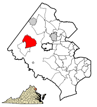
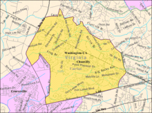
Chantilly, Virginia — CDP — Location of Chantilly in Fairfax County, Virginia Coordinates: 38°52′30″N 77°24′9″W / 38.875°N 77.4025°WCoordinates: 38°52′30″N 77°24′9″W / 38.875°N 77.4025°W Country United States State Virginia County Fairfax, Loudoun Area - Total 11.7 sq mi (30.199 km2) - Land 11.7 sq mi (30.199 km2) - Water 0.0 sq mi (0.00 km2) Elevation 322 ft (98 m) Population (2010) - Total 23,039 - Density 3,519.8/sq mi (1,359.0/km2) Time zone Eastern (UTC-5) - Summer (DST) Eastern (UTC-4) ZIP codes 20151, 20152, 20153 Area code(s) 703, 571 FIPS code 51-14744[1] GNIS feature ID 1495375[2] Chantilly is an unincorporated community located in western Fairfax County and southeastern Loudoun County of Northern Virginia. Recognized by the U.S. Census Bureau as a census designated place (CDP), the community population was 23,039 as of the 2010 census -- down from 41,041 in 2000, due to the splitting off of parts of it to form new CDP's including Greenbriar and Fair Lakes. It is named after an early 19th century mansion and farm.[3]
Chantilly is part of the Washington metropolitan area and is approximately 24 miles (39 km) from Washington, D.C.
Chantilly is home to Washington Dulles International Airport, which serves Washington, D.C. It is also the location of the Steven F. Udvar-Hazy Center annex of the National Air & Space Museum and the headquarters of the National Reconnaissance Office.
Chantilly was also home to the annual Bilderberg summit in 2008.
Contents
History
Chantilly was home to a number of colonial plantations in the 1700s, including "Sully," built by Richard Bland Lee I, George Richard Lee Turberville's "Leeton," and the John Hutchison Farm.
Growth of the village predominantly occurred during the 19th century, particularly following the construction of Little River Turnpike (Route 236) to Winchester.
During the American Civil War on September 1, 1862, the Battle of Chantilly (or Ox Hill) was fought nearby. Following his victory at the Second Battle of Bull Run (or Second Manassas), Confederate General Robert E. Lee directed Major General Thomas J. "Stonewall" Jackson to cross Bull Run on August 31 and sweep around the position of Major General John Pope's Union Army of Virginia at Centreville. Reaching the Little River Turnpike northwest of Centreville, Jackson turned southeastward toward Fairfax Court House (now Fairfax, Virginia) to strike in rear of Pope's army.
During September 1, Pope, apprised of Jackson's movement, began to withdraw toward Fairfax Court House. Late in the day, Jackson clashed with Union forces under Brigadier General Isaac Stevens and Major General Philip Kearny near Ox Hill, west of Fairfax. During the ensuing battle, which was fought amid a raging storm, both Union generals Stevens and Kearny were killed. The fighting ended at dusk, and Pope's army continued its withdrawal to Fairfax and subsequently to the Washington defenses.
Although commercial and residential development now covers most of the Chantilly (Ox Hill) battlefield, a small county park preserves a five acre (19,000 m²) portion of the battle site.
Geography
Chantilly is located at 38°53′39″N 77°25′52″W / 38.89417°N 77.43111°W (38.894146, -77.431407)[4].
Informally, Chantilly is located around the intersection of US-50 (Lee Jackson Memorial Hwy) and VA-28 (Sully Rd).
According to the United States Census Bureau, the CDP has a total area of 11.7 square miles (30.2 km²), all of it land.
Chantilly has some land area that is located in Loudoun County, Virginia.
Chantilly is served by US-50, the Fairfax County Parkway, and Virginia State Route 28 (Sully Road).
Demographics
Historical populations Census Pop. %± 1980 12,259 — 1990 29,337 139.3% 2000 41,041 39.9% 2010 23,039 −43.9% source:[5] As of the census[1] of 2000, there were 41,041 people, 14,840 households, and 10,521 families residing in the CDP. The population density was 3,519.4 people per square mile (1,359.0/km²). There were 15,173 housing units at an average density of 1,301.1/sq mi (502.4/km²). The racial makeup of the CDP was 73.34% White, 4.99% African American, 0.29% Native American, 16.36% Asian, 0.06% Pacific Islander, 2.01% from other races, and 2.96% from two or more races. Hispanic or Latino of any race were 6.87% of the population.
There were 14,840 households out of which 38.1% had children under the age of 18 living with them, 60.6% were married couples living together, 7.4% had a female householder with no husband present, and 29.1% were non-families. 20.2% of all households were made up of individuals and 2.1% had someone living alone who was 65 years of age or older. The average household size was 2.75 and the average family size was 3.24.
In the CDP the population was spread out with 26.1% under the age of 18, 7.8% from 18 to 24, 38.4% from 25 to 44, 23.0% from 45 to 64, and 4.8% who were 65 years of age or older. The median age was 34 years. For every 100 females there were 98.4 males. For every 100 females age 18 and over, there were 96.1 males.
According to a 2007 estimate, the median income for a household in the CDP was $105,838, and the median income for a family was $126,290. Males had a median income of $61,954 versus $41,608 for females. The per capita income for the CDP was $36,200. About 1.3% of families and 2.3% of the population were below the poverty line, including 1.7% of those under age 18 and 5.5% of those age 65 or over.
The area is seen by many as a "boom town" with more development planned for the future alongside ongoing construction throughout. Chantilly is home to many professionals including physicians that contract with the nearby airports and the government.
Economy
The American Registry for Internet Numbers is headquartered in an unincorporated area by Washington Dulles International Airport, near Chantilly.[6][7][8]
At one time Compass Airlines was headquartered near Chantilly, in an unincorporated area. The headquarters was relocated to Minnesota in late 2009.[9][10][11]
Education
Primary and secondary schools
Residents of the CDP go to Fairfax County Public Schools.
Elementary schools within the CDP include Brookfield Elementary School, Greenbriar East Elementary School, Greenbriar West Elementary School, Lees Corner Elementary School, Navy Elementary School, and Poplar Tree Elementary School.[7]
Rocky Run Middle School, Franklin Middle School, and Chantilly High School are located within the CDP. Westfield High School is a large high school located outside of the CDP.[7]
St. Timothy School and St. Veronica School, private Catholic schools, are located in the CDP.[7]
Public libraries
Fairfax County Public Library operates the Chantilly Regional Library in the CDP.[7][12]
Media
Newspapers
Chantilly is served by The CentreView.
See also
- Sully Historic Site
- Willard, Virginia, adjacent town displaced for construction of Dulles Airport
References
- ^ a b "American FactFinder". United States Census Bureau. http://factfinder.census.gov. Retrieved 2008-01-31.
- ^ "US Board on Geographic Names". United States Geological Survey. 2007-10-25. http://geonames.usgs.gov. Retrieved 2008-01-31.
- ^ Debbie Robison (October 23, 2007). "Chantilly, ca. 1817". Northern Virginia History Notes. http://www.novahistory.org/Chantilly.html. Retrieved November 7, 2009.
- ^ "US Gazetteer files: 2010, 2000, and 1990". United States Census Bureau. 2011-02-12. http://www.census.gov/geo/www/gazetteer/gazette.html. Retrieved 2011-04-23.
- ^ "CENSUS OF POPULATION AND HOUSING (1790-2000)". U.S. Census Bureau. http://www.census.gov/prod/www/abs/decennial/index.html. Retrieved 2010-07-17.
- ^ "Contact Us." American Registry for Internet Numbers. Retrieved on September 16, 2009.
- ^ a b c d e "Chantilly CDP, Virginia." U.S. Census Bureau. Retrieved on September 16, 2009.
- ^ "ARIN Upgrades IPv6 Network Services With Dual Stack GigE Internet Access From NTT America." Red Orbit. Tuesday September 2, 2008. Retrieved on September 16, 2009.
- ^ "About Us." Compass Airlines. Retrieved on February 28, 2010.
- ^ "About Us." Compass Airlines. Retrieved on September 26, 2009.
- ^ "Chantilly CDP, Virginia." U.S. Census Bureau. Retrieved on September 26, 2009.
- ^ "Library Branches." Fairfax County Public Library. Retrieved on October 21, 2009.
External links
- Chantilly High School
- Chantilly Regional Library
- Dulles South area community portal serving Chantilly and South Riding
- Census Tract Outline Map - Fairfax County
Categories:- Census-designated places in Virginia
- Populated places in Fairfax County, Virginia
- Unincorporated communities in Virginia
- Baltimore–Washington metropolitan area
Wikimedia Foundation. 2010.


