- Dummerston, Vermont
-
Dummerston, Vermont — Town — West Dummerston Covered Bridge Dummerston, Vermont
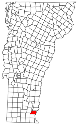
Coordinates: 42°55′21″N 72°34′40″W / 42.9225°N 72.57778°WCoordinates: 42°55′21″N 72°34′40″W / 42.9225°N 72.57778°W Country United States State Vermont County Windham Chartered 1753 Area – Total 30.8 sq mi (79.8 km2) – Land 30.6 sq mi (79.2 km2) – Water 0.2 sq mi (0.6 km2) Elevation 814 ft (248 m) Population (2000) – Total 1,915 – Density 62.6/sq mi (24.2/km2) Time zone Eastern (EST) (UTC-5) – Summer (DST) EDT (UTC-4) ZIP code 05301 Area code(s) 802 FIPS code 50-18325[1] GNIS feature ID 1462084[2] Dummerston is a town in Windham County, Vermont, United States. The population was 1,915 at the 2000 census. Dummerston is home to the longest covered bridge still in use inside the state borders of Vermont.
Contents
History
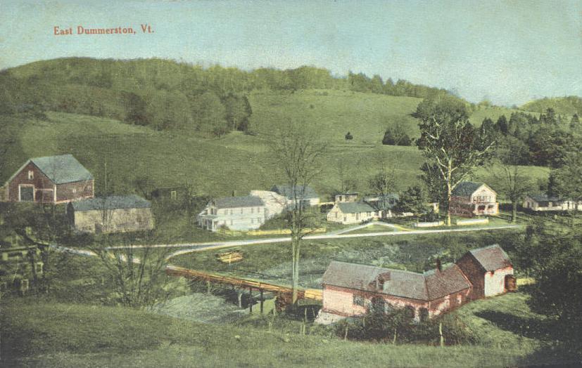
 East Dummerston in 1913
It was part of a tract given to Connecticut about 1713 by Massachusetts in compensation for land mistakenly awarded by the latter to settlers. In 1716, the town was auctioned to a consortium including William Dummer, lieutenant governor of Massachusetts, and named Dummerston. On December 26, 1753, the town was chartered as a New Hampshire grant and renamed Fulham by Governor Benning Wentworth. But when the grant was renegotiated, it reverted to Dummerston.[3]
The West River provided water power for mills, and Dummerston had five gristmills. five sawmills, one slate manufacturer, and one shop for making rakes. Raising sheep across the many hills was an important occupation.[4] By 1859, the town had a population of 1,645. The Vermont Valley Railroad passed through Dummerston.[3] Built in 1892, Naulakha was home to author Rudyard Kipling. His house is now a museum available for overnight stays.[5]
In 2006, Dummerston was one of the first American towns to have its citizens pass a resolution endorsing the impeachment of President George W. Bush.
Geography
According to the United States Census Bureau, the town has a total area of 30.8 square miles (79.8 km2), of which 30.6 square miles (79.2 km2) is land and 0.2 square mile (0.6 km2) (0.71%) is water. Dummerston is bounded by the Connecticut River, and the West River flows through the town.[6]
The town is crossed by Interstate 91, U. S. Route 5 and Vermont Route 30. It is bordered by Brattleboro to the south, Marlboro and Newfane to the west, with Putney and Brookline to the north. Chesterfield, New Hampshire lies across the Connecticut River.
Demographics
As of the census[1] of 2000, there were 1,915 people, 796 households, and 543 families residing in the town. The population density was 62.6 people per square mile (24.2/km2). There were 893 housing units at an average density of 29.2 per square mile (11.3/km2). The racial makeup of the town was 98.33% White, 0.05% African American, 0.63% Asian, 0.05% from other races, and 0.94% from two or more races. Hispanic or Latino of any race were 0.57% of the population.
There were 796 households out of which 31.8% had children under the age of 18 living with them, 58.0% were married couples living together, 6.8% had a female householder with no husband present, and 31.7% were non-families. 25.4% of all households were made up of individuals and 6.9% had someone living alone who was 65 years of age or older. The average household size was 2.41 and the average family size was 2.89.
In the town the population was spread out with 23.1% under the age of 18, 5.1% from 18 to 24, 26.8% from 25 to 44, 31.1% from 45 to 64, and 13.9% who were 65 years of age or older. The median age was 42 years. For every 100 females there were 101.2 males. For every 100 females age 18 and over, there were 97.1 males.
The median income for a household in the town was $46,121, and the median income for a family was $53,375. Males had a median income of $35,664 versus $26,174 for females. The per capita income for the town was $23,742. About 1.1% of families and 2.4% of the population were below the poverty line, including 2.7% of those under age 18 and 6.5% of those age 65 or over.
Sites of interest
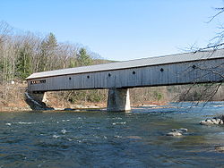 1872 West Dummerston Covered Bridge -- floor length 267 feet (81 m)
- Black Mountain Natural Area
- Dummerston Grange -- Vermont Theatre Company
- Naulakha -- the Rudyard Kipling home
- West Dummerston Covered Bridge
Notable people
- George Aiken, governor and senator.
- Tom Bodett, author and voice actor.
- Robert J. Flaherty, filmmaker and producer.
- Rudyard Kipling, author and inventor of snow golf.
- Charles Sweetser, congressman.
References
- ^ a b "American FactFinder". United States Census Bureau. http://factfinder.census.gov. Retrieved 2008-01-31.
- ^ "US Board on Geographic Names". United States Geological Survey. 2007-10-25. http://geonames.usgs.gov. Retrieved 2008-01-31.
- ^ a b Coolidge, Austin J.; John B. Mansfield (1859). A History and Description of New England. Boston, Massachusetts. pp. 792–795. http://books.google.com/books?id=OcoMAAAAYAAJ&lpg=PA9&dq=coolidge%20mansfield%20history%20description%20new%20england%201859&pg=PA792#v=onepage&q=&f=false.
- ^ Hayward's New England Gazetteer of 1839
- ^ Virtual Vermont -- Dummerston, Vermont
- ^ DeLorme (1996). Vermont Atlas & Gazetteer. Yarmouth, Maine: DeLorme. ISBN 0-89933-016-9
External links
Municipalities and communities of Windham County, Vermont Towns Athens | Brattleboro | Brookline | Dover | Dummerston | Grafton | Guilford | Halifax | Jamaica | Londonderry | Marlboro | Newfane | Putney | Rockingham | Somerset‡ | Stratton | Townshend | Vernon | Wardsboro | Westminster | Whitingham | Wilmington | Windham

Villages CDPs Other
communitiesFootnotes ‡ Disincorporated
Categories:- Towns in Vermont
- Dummerston, Vermont
- Populated places on the Connecticut River
- Populated places in Windham County, Vermont


Wikimedia Foundation. 2010.