- Craftsbury, Vermont
-
Craftsbury, Vermont — Town — Located in Orleans County, Vermont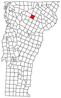 Location of Vermont with the U.S.A.
Coordinates: 44°39′29″N 72°22′45″W / 44.65806°N 72.37917°WCoordinates: 44°39′29″N 72°22′45″W / 44.65806°N 72.37917°W Country United States State Vermont County Orleans Chartered August 23, 1781 Area – Total 39.7 sq mi (102.9 km2) – Land 39.3 sq mi (101.7 km2) – Water 0.4 sq mi (1.1 km2) Elevation 904 ft (272 m) Population (2000) – Total 1,136 – Density 28.9/sq mi (11.2/km2) – Households 427 – Families 301 Time zone EST (UTC-5) – Summer (DST) EDT (UTC-4) ZIP code 05826-05827 Area code(s) 802 FIPS code 50-16300[1] GNIS feature ID 1462078[2] Website www.townofcraftsbury.com Craftsbury is a town in Orleans County, Vermont, United States. The population was 1,136 at the 2000 census. The town includes the four unincorporated villages of Craftsbury Common, Mill Village, North Craftsbury and East Craftsbury.
Contents
Government
Town
- Moderator - Anne Wilson[3]
- Selectman - Bruce Urie
- Town Clerk - Yvette Brown
- Agent - Tom Wells
- Treasurer - Yvette Brown
- Collector of Taxes - Yvette Brown
- Auditor - Lisa Santamore
- Lister - Tom Wells
- Lister - William Ryan
- Grand Juror - Tom Hadden
- Cemetery Commissioner - Faye Waterhouse
- Trustee of Public Funds - Rita Davis
- Trustee of WWII Memorial Fund - Clyde Simmons Jr.
- Supervisor, Lamoille Solid Waste District - Adrian Owens
- Budget - $618,314
State Representatives
Craftsbury is represented in the Vermont General Assemblyby two Senators and two Representatives, all elected for two year terms.
For the purposes of representation in the House Craftsbury is part of the Orleans-Caledonia 1 district, which includes the towns of Barton, Glover, Sheffield, Wheelock, Albany Greensboro and Craftsbury. For 2009 and 2010 the representatives from this district were John Morley (a Republican) and John Rogers (a Democrat) [4]
Education
Sterling College is located here.
Public schools
Craftsbury runs the Craftsbury Schools System, which includes the historic Craftsbury Academy.
- Superintendent - JoAn Canning
- Principal - Merri Greenia
- Budget - $2,932,930
History
The state granted the town to Ebenezer Crafts, Timothy Newell, and sixty-two associates, on November 6, 1780. They named it Minden. It was changed to Craftsbury, in honor of Ebenezer Crafts, on October 27, 1790. Crafts was the first settler in the county.[5]
North Craftsbury was settled by the earliest pioneers, and was for many years the center of business and trade, not only for Craftsbury, but for Eden, Lowell, Albany, and portions of the neighboring towns.[5] Continuing trouble with American Indians led to the successive founding of Craftsbury village (in a valley), East Craftsbury (on higher ground) and Craftsbury Common (on a hilltop).
The militia was drilled here on the common while such training took place. All the public and religious meetings were held here. Along with Brownington, Craftsbury was a co-county seat until 1815 when it switched to Irasburg. Orleans county courts were held alternately at Craftsbury and Brownington.[5]
Geography
According to the United States Census Bureau, the town has a total area of 39.7 square miles (102.9 km2). 39.3 square miles (101.7 km2) of it is land and 0.4 square miles (1.1 km2) of it (1.11%) is water.
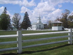 A view across Craftsbury Common showing the United Church of Craftsbury, and bandstand.
Craftsbury is on a plateau on the Catamount Trail.[6]
There are many hills and valleys. The soil varies from alluvial meadows to clay and gravel. There are more numerous grades and varieties of soil than is usual.[5]
There are five ponds or lakes.
Lake Elligo (also known as Eligo Pond) is partially in Greensboro. It is about two miles long and half a mile wide. Unusually, it has two outlets: one flows to the north and the other to the south. The northern outlet is one of the head branches of Black River. The southern flows through Little Elligo Pond and on to the Lamoille River in Hardwick. The eastern shore rises to cliffs. The western shore rises gradually. Near the center of the pond are two small islands. The lake was formerly a hunting-ground of the St. Francis Indians, who named it Elligo Scoloon.[5]
The others are Great Hosmer Pond, lying partly in Albany, Little Hosmer Pond, and two other small ponds. The Black River is the main river in town. It was called Elligo-sigo by the natives. Its current is slow. The drop from its source to Lake Memphremagog, including the falls at Irasburg and Coventry, is 190 feet. Wild branch, a tributary of the Lamoille, rises in Eden and flows through the western part of the town. The valley of the Black river in Craftsbury is a muck bed averaging a quarter of a mile in width.[5]
Geology
Geologically, the town varies in its structure to an unusual degree. There is granite in the east part of town. This alternates with gneiss and mica slate. In the central portions of town, the previous rocks are replaced by dark argellaceous slate. This alternates with silicious limestone.[5]
The rocks on the west side of the Black River also vary. Strata of mica slate, argellaceous, and chlorite slates, and limestones, alternate. An extensive deposit of gray granite is near Craftsbury village. It is broken on the surface. This rock is filled with nodules of black mica and quartz, in concentric layers. These are about one inch in diameter. In much of the area, the biotite orbicules are so numerous that a hundred may be counted within a circle two feet in diameter. In some parts of the ledge these nodules are flattened, as if subjected to an immense vertical pressure when the mass was in a semi-fluid state. In the nineteenth century these rocks were once believed to be unique from any other found in America or Europe.[5] Today, it is known that they resemble those found in Bethel granite.[7]
Demographics
As of the census[1] of 2000, there were 1,136 people, 427 households, and 301 families residing in the town. The population density was 28.9 inhabitants per square mile (11.2/km2). There were 572 housing units at an average density of 14.6 per square mile (5.6/km2). The racial makeup of the town was 96.74% White, 0.35% African American, 0.09% Native American, 0.44% Asian, and 2.38% from two or more races. Hispanic or Latino of any race were 1.14% of the population.
There were 427 households out of which 31.1% had children under the age of 18 living with them, 61.8% were couples living together and joined in either marriage or civil union, 5.9% had a female householder with no husband present, and 29.3% were non-families. 21.1% of all households were made up of individuals and 9.4% had someone living alone who was 65 years of age or older. The average household size was 2.43 and the average family size was 2.82.
In the town the population was spread out with 21.0% under the age of 18, 9.6% from 18 to 24, 24.6% from 25 to 44, 25.3% from 45 to 64, and 19.6% who were 65 years of age or older. The median age was 41 years. For every 100 females there were 91.2 males. For every 100 females age 18 and over, there were 90.3 males.
The median income for a household in the town was $34,453, and the median income for a family was $41,000. Males had a median income of $21,875 versus $24,375 for females. The per capita income for the town was $17,185. About 11.2% of families and 13.8% of the population were below the poverty line, including 15.4% of those under age 18 and 15.2% of those age 65 or over.
Town population reached its peak in 1860 with 1,413 people. It reached a low of 632 in 1970.
Culture
The Craftsbury Chamber Players have offered summer performances since 1966.[8]
Notable people
- Edwin Eugene Bagley, composer.
- Samuel C. Crafts, Vermont governor, U.S. Congressman, and U.S. senator and son of the town's founder
- Horace F. Graham, Governor of Vermont 1917-1919[9]
- Bill "The Spaceman" Lee, pitcher for the Boston Red Sox (1969–1978) and Montreal Expos (1979–1982).
Craftsbury in film
Alfred Hitchcock shot the scenery for his 1955 movie The Trouble with Harry in Craftsbury. Ostensibly, the movie takes place entirely in town. Exteriors of the parsonage beside the East Craftsbury Presbyterian Church are used as well as exterior shots of Craftsbury Common. Assuming that the town would be in full foliage the company, showed up for outdoor shots on September 27, 1954. To the filmmakers' shock, there was hardly any foliage left; to achieve a full effect, leaves were glued to the trees.[10]
The 1976 IMAX film To Fly! a history of human flight, directed by Jim Freeman and Greg MacGillivray and produced for the Smithsonian Institution's National Air and Space Museum opens with a hot air balloon passing over the Wee House and the United Church of Craftsbury on the Common.
Economy
Tourist industry
The Craftsbury Outdoor Center has over 85 kilometres (53 mi) of Nordic skiing trails, used for running in the summer months.
In 1981, the first annual Craftsbury (winter) Marathon was held. In 2008, 646 skiers from 20 states and 3 provinces attended along with 295 tourists.[11]
The Craftsbury sculling center is one of the most renowned sculling programs in the United States,[citation needed] based on Little and Big Hosmer lake.
Transportation
Craftsbury is served by Vermont Route 14 which passes near the villages of Craftsbury and Craftsbury Common.
References
- ^ a b "American FactFinder". United States Census Bureau. http://factfinder.census.gov. Retrieved 2008-01-31.
- ^ "US Board on Geographic Names". United States Geological Survey. 2007-10-25. http://geonames.usgs.gov. Retrieved 2008-01-31.
- ^ Voters avoid bad corner of gymnasium, The Chronicle"", March 7, 2007, page 26
- ^ [1]
- ^ a b c d e f g h Gazetteer of Lamoille and Orleans Counties, VT.; 1883-1884, Compiled and Published by Hamilton Child; May 1887
- ^ Northeast Kingdom of Vermont - Things to do and Places to go. Paul Essaff - Northeast Kingdom Business Directory. 2007.
- ^ Van Diver, Bradford B. (1987). Roadside Geology. Mountain Press Publishing Company.
- ^ [2] retrieved September 28, 2008
- ^ [3]
- ^ Barton Chronicle book review retrieved August 21, 2009
- ^ Anderson, Ryan Peter (February 6, 2008). Ski marathoners survive terrible weather. the Chronicle.
Further reading
Metraux, Daniel A. Craftsbury: A Brief Social History. Writers Club Press: 2001. ISBN 0595193927.
External links
- Virtual Vermont Craftsbury web page
- Sterling College
- Craftsbury Outdoor Center
- History of Craftsbury from the Orleans County Historical Society
Municipalities and communities of Orleans County, Vermont City 
Towns Villages Albany | Barton | Derby Center | Derby Line | North Troy | Orleans
Unincorporated
communityCategories:- Craftsbury, Vermont
- Towns in Vermont
- Populated places in Orleans County, Vermont


Wikimedia Foundation. 2010.