- Mount Lofty
-
This article is about the South Australian mountain. For other meanings, see Mount Lofty (disambiguation).
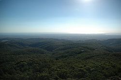
 View of the Mount Lofty Ranges from the Summit.
Mount Lofty (34°58′S 138°42′E / 34.967°S 138.7°E, elevation 727 metres AHD) is the highest point in the Mount Lofty Ranges. It is located about 15km east of the centre of the city of Adelaide in South Australia and gives unrivalled panoramic views of the city and the Adelaide plains and foothills. It was first climbed by a European when explorer Collet Barker climbed it in April 1831, almost seven years before Adelaide was settled. It was named by Matthew Flinders on his circumnavigation of Australia in 1802.
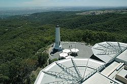
The Summit was closed to the public during World War 2, when the obelisk was considered an indispensable navigation assistant. A flashing strobe was fitted to the top to improve visibility at night. This strobe was removed after the war, but then re-installed in the 1990s, when the obelisk was repainted and restored during construction of the new kiosk.
Access to the summit can be gained by road from the South Eastern Freeway at Crafers, or from the eastern suburbs via Greenhill Road. The more enthusiastic can walk up the gully from Waterfall Gully, in the Cleland Conservation Park or from Chambers Gully. The summit provides panoramic views across Adelaide, and a cafe-restaurant and gift shop. These are relatively new due to protracted disputes over appropriate development following the destruction of the old cafe in the 1983 Ash Wednesday fires.
On the ridge near the summit are the television transmission towers for the Adelaide television stations, and the Mount Lofty Fire Tower operated by the Country Fire Service.
This is becoming a popular spot for tourists to Adelaide and also for cyclists coming up the old Mount Barker Road through Eagle on the Hill; this section of highway has now been superseded by the Heysen Tunnels.
Light snowfalls are not uncommon on the summit, although it is possible for Mount Lofty to go two or three years with out any snowfall. Mount Lofty is the coldest location in Adelaide, during winter months the temperature will not surpass 3-4 degrees Celsius some days. It is the most common location for snow in South Australia, with other rare snowfalls in other parts of the Mount Lofty Ranges and Northern South Australia.
 View of Adelaide at night from the summit.
 View of Adelaide CBD during the day from the summit.
Towns and Localities of the Adelaide Hills Council Aldgate · Ashton · Balhannah · Basket Range · Birdwood · Bradbury · Bridgewater · Carey Gully · Castambul · Chain of Ponds · Charleston · Cherryville · Cleland · Crafers · Crafers West · Cromer · Cudlee Creek · Dorset Vale · Forest Range · Forreston · Greenhill · Gumeracha · Heathfield · Horsnell Gully · Houghton · Humbug Scrub · Inglewood · Ironbank · Kersbrook · Lenswood · Lobethal · Longwood · Lower Hermitage · Marble Hill · Millbrook · Montacute · Mount George · Mount Torrens · Mylor · Norton Summit · Oakbank · Paracombe · Piccadilly · Scott Creek · Stirling · Summertown · Teringie · Upper Hermitage · Upper Sturt · Uraidla · Verdun · Woodforde · WoodsideAdelaide Hills, South Australia Major Townships Birdwood · Clarendon · Echunga · Gumeracha · Hahndorf · Littlehampton · Lobethal · Macclesfield · Meadows · Mount Barker · Mylor · Nairne · Oakbank · Stirling · WoodsideAttractions See also Categories:- Adelaide Hills, South Australia
- Mountains of South Australia
Wikimedia Foundation. 2010.

