- Mount Lofty railway station
-
 Mount Lofty
Railways in Adelaide - List of Railway Stations 
Train Services Location Street Sturt Valley Road Suburb Stirling Distance from Adelaide ~31 km Access by n/a (Station closed) Frequency Hi-Frequency Station n/a Peak Frequency n/a Weekday Frequency n/a Weekend Frequency n/a Night Frequency n/a Facilities Real Rail Time Display No Real Rail Time Speaker No Number of Platforms 2 (Not in use) Platform Layout Side platform Toilets No Car Parking No Bike Storage No Lounge No Kiosk No Wheelchair access 
No Other facilities holiday and tourist accommodation History Opened 1883 Closed 1987 Transfers Train transfer None Bus transfer None Adjacent Stations « Previous
Upper Sturt (Closed)Next »
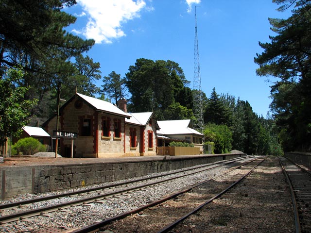
Heathfield (Closed)Mount Lofty Railway Station is a railway station in South Australia, on the former Adelaide-Bridgewater railway line, located in the Adelaide Hills suburb of Stirling. The station opened in 1883 and it is located 31.0 km (19m41c) by rail from the Adelaide Railway Station. It is the highest railway station between Adelaide and Melbourne.
Two platforms were provided. The north or 'Down' platform is 125.0 metres long and the south or 'Up' platform is 103.6 metres long. Both platforms are still in place, although no longer in use. The wooden stairs leading down from the footbridge to the south platform are still in place and have been refurbished, but are not serviceable. The station signs on both platforms, which were mainly used at stations in the hills and near the beach (eg Belair and Semaphore respectively) from early in the 1900s to the 1980s, are also still in place. The small traditional wooden shelter which once graced the north platform no longer exists. Neither does the signal box which once stood high next to the bridge on the south platform. This was demolished when main building was extended to include a new signal box in 1929.
Until 1987 Adelaide suburban trains serviced the station and went further east to Bridgewater. The trains were withdrawn in that year because of high cost of operating the trains and low passenger numbers. All railway stations beyond Belair, including Mount Lofty railway station were closed to suburban trains, and most of the other stations have since been demolished .
In 1995 the main railway line from Adelaide to Melbourne was converted from Broad Gauge (1600mm) to Standard Gauge (1435mm), thus preventing any restoration of local trains to Mount Lofty and beyond, as the Adelaide suburban system remained as broad gauge. At the station there are three standard gauge railway tracks, two for interstate freight, and the third is used to stable track machines. The southern track is the main line and the northern track is the crossing loop. As the length of the crossing loop is 629 metres, the crossing of trains at Mount Lofty is rare.
Today, Mount Lofty Railway Station is holiday & tourist accommodation with a comfortable and quaint railway theme. Bookings can be made throughout the year. From a derelict state, the station building was rebuilt in the mid 1990s in a project managed by Stirling Council using Federal Government retraining funding. In 1999-2000, the Emmett family of Stirling completed the rebuild to suit it's current use as accommodation, and still operate it today (2011) on lease from the South Australian Government. Interstate freight trains and the interstate passenger express "The Overland" pass through the station each day, but the platforms are only used for special trains or in an emergency .
References
South Australian Railways Working Timetable Book No. 265 effective 10:00am, Sunday, 30 June 1974.
Australian National Working Timetable Book No. 286 effective 0001 hrs Sunday, 25 October 1987.
External links
Coordinates: 35°00′28″S 138°42′34″E / 35.0077°S 138.7095°E
Categories:- South Australia rail transport stubs
- Disused railway stations in South Australia
- Railway stations opened in 1883
Wikimedia Foundation. 2010.