- Nairne, South Australia
-
Nairne
South Australia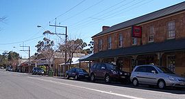
Main Street, Nairne
 Nairne
Population: 3,470 (2006 Census)[1] Established: 1839 Postcode: 5252 Location: - 9 km (6 mi) from Mount Barker
- 42 km (26 mi) from Adelaide
LGA: District Council of Mount Barker State District: Kavel Federal Division: Mayo Localities around Nairne: Brukunga Littlehampton Nairne Dawesley Mt Barker Mt Barker Mt Barker Nairne is a small township in South Australia and was founded by Matthew Smillie in 1839. Nairne is about 7 km from Mount Barker, in the federal Division of Mayo and in the state electoral district of Kavel. At the 2006 census, Nairne had a population of 3,470.[1]
Contents
History
Nairne began as a town on Princes Highway, which used to be the main traffic route from Sydney to Adelaide (via Melbourne) before the South Eastern Freeway superseded this section of highway in 1969.
In 2003, the main street was transformed for a section of the movie The Honourable Wally Norman, which was filmed using various areas of the Adelaide Hills, including Mount Barker, Nairne and Lobethal.
Demographics
Nairne has several shops on the main street, a school, and two churches (CRC and Lutheran). It is about 7 km from the town of Mount Barker and about 5 km from Littlehampton.
Notes and references
- ^ a b Australian Bureau of Statistics (25 October 2007). "Nairne (Urban Centre/Locality)". 2006 Census QuickStats. http://www.censusdata.abs.gov.au/ABSNavigation/prenav/LocationSearch?collection=Census&period=2006&areacode=UCL418200&producttype=QuickStats&breadcrumb=PL&action=401. Retrieved 14 October 2011.
External links
Adelaide Hills, South Australia Major Townships Birdwood · Clarendon · Echunga · Gumeracha · Hahndorf · Littlehampton · Lobethal · Macclesfield · Meadows · Mount Barker · Mylor · Nairne · Oakbank · Stirling · WoodsideAttractions See also Categories:- Towns in South Australia
- Adelaide Hills, South Australia


Wikimedia Foundation. 2010.