- Dubai route numbering system
-
The Dubai route numbering system is a network of highways and roads in Dubai, United Arab Emirates that is managed by the Roads and Transport Authority (RTA). The network comprises 6 main highways and several major and minor inter-city and intra-city roads.
Contents
Routes
E-routes
 E 44 - Dubai-Hatta Highway sign
Highways connecting Dubai to other emirates are designated Emirates routes or E-routes. They are identified by an emblem of a falcon, the letter E and a two or three digit number. While within city limits, most roads and highways take alternate names, but are consistently identified by their corresponding E-route number. Six E-routes pass through Dubai, connecting the city with other emirates and towns:[1]
- E 11 (Sheikh Zayed Road)
- E 311(Emirates Road)
- E 44 (Al Khail Road; Dubai-Hatta Highway)
- E 66 (Dubai-Al Ain Highway)
- E 77 (Dubai-Al Habab Road)
- E 611(Dubai Bypass Road)
- E 55 (Goes to Adh Dhayd)
- E 22 (Khalifa Ibn Zayed Street; goes to Al Khaznah)
The longest of the E-routes is E 11, which extends the length of the UAE's Persian Gulf coast and connects all emirates, with the exception of Al Fujairah.
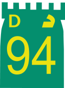
D-routes
 Jumeirah Road sign
D-routes connect localities within the city of Dubai and are identified by the emblem of a fort, the letter D and a two or three digit number. Considerably shorter in length than the average E-route, D-routes provide an intra-city network of roads and streets. D-routes parallel to UAE's coast along the Persian Gulf are numbered evenly, beginning with D 94; the numbers decrease as the network moves farther from the coast. D-routes perpendicular to the Persian Gulf coast are odd numbered and increase as the network moves towards the emirate of Sharjah. Some of the D-routes include:[1]
- D 97 (Amman Street)
- D 95 (Al Mamzar Road (Cairo Street); Baghdad Street)
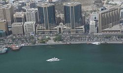
- D 94 (Jumeirah Road)
- D 93 (Al Wuheida Road; Al Nahada Road; Tunis Street)
- D 92 (Al Wasl Road; Al Mina Road; Al Khaleej Road)
- D 91 (Abu Hail Road)
- D 90 (Al Satwa Road; Mankhool Road; Al Muasallah Road)
- D 89 (Al Maktoum Road; Airport Road; Al Khawaneej Road)
- D 88 (On Bur Dubai side Sheikh Khalifa Bin Zayed Road and on Deira side Omar Bin Al Khattab Road)
- D 85 (Baniyas Road)
- D 84 (Al Seef Road; Zabeel Road)
- D 83 (Umm Ramool Road)
- D 82 (Al Naif Road; Al Rasheed Road)
- D 81 (Riyadh Street)
- D 80 (Salahuddin Road)
- D 79 (Khalid bin al Waleed Road, Tariq Bin Ziyad Road, Oud Metha Road)
- D 78 (Abu Baker Al Siddique Road)
- D 77 (Al Kuwait Street)
- D 75 (Sheikh Rashid Road)
- D 73 (Al Dhiyafa Road)
- D 71 (Al Doha Street)
- D 70 (Casablanca Road)
- D 69 (Al Hadiqa Street; Muscat Street)
- D 67 (Academic Road; Manama Street)
- D 64 (Al Qusais Road; Damascus Street)
- D 63 (Umm Suqeim Street)
- D 62 (Nadd Al Hammar Road)
- D 60 (Al Rashidiya Road)
- D 56 ()
- D 54 (Academic City Road)
- D 50 (Aweer Khawaneej Road)
Major roads
Major roads typically surround a community or locality within the city and are addressed by a name and a three digit identification number. Streets within a locality are identified with a two digit number. Street numbers are repeated within each locality.[1]
References
- ^ a b c "Reading Dubai's road signs". Gulf News. 2006-09-08. http://archive.gulfnews.com/articles/06/09/08/10065868.html. Retrieved 2008-02-24.
See also
- List of roads in Dubai
Categories:- Streets in Dubai
- Transport in Dubai
- Geography of Dubai


Wikimedia Foundation. 2010.