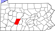
- Daisytown, Pennsylvania
-
Daisytown, Pennsylvania — Borough — Coordinates: 40°19′11″N 78°54′01″W / 40.31972°N 78.90028°WCoordinates: 40°19′11″N 78°54′01″W / 40.31972°N 78.90028°W Country United States State Pennsylvania County Cambria Settled 1776 Incorporated 1893 Government – Type Borough Council – Mayor Area – Total 0.3 sq mi (0.8 km2) Elevation 1,801 ft (549 m) Population (2000) – Total 356 – Density 1,280.6/sq mi (494.4/km2) Time zone Eastern (EST) (UTC-5) – Summer (DST) EDT (UTC-4) Zip code 15427 Area code(s) 814 Daisytown is a borough in Cambria County, Pennsylvania, United States. It is part of the Johnstown, Pennsylvania Metropolitan Statistical Area. The population was 356 at the 2000 census.
Geography
Daisytown is located at 40°19′11″N 78°54′1″W / 40.31972°N 78.90028°W (40.319674, -78.900211)[1].
According to the United States Census Bureau, the borough has a total area of 0.3 square miles (0.78 km2), all of it land.
Demographics
As of the census[2] of 2000, there were 356 people, 139 households, and 104 families residing in the borough. The population density was 1,280.6 people per square mile (490.9/km²). There were 145 housing units at an average density of 521.6 per square mile (199.9/km²). The racial makeup of the borough was 98.88% White, 0.28% African American, 0.28% Native American, and 0.56% from two or more races.
There were 139 households out of which 30.9% had children under the age of 18 living with them, 64.0% were married couples living together, 7.9% had a female householder with no husband present, and 24.5% were non-families. 20.9% of all households were made up of individuals and 10.1% had someone living alone who was 65 years of age or older. The average household size was 2.56 and the average family size was 2.99.
In the borough the population was spread out with 22.8% under the age of 18, 5.3% from 18 to 24, 27.5% from 25 to 44, 28.9% from 45 to 64, and 15.4% who were 65 years of age or older. The median age was 41 years. For every 100 females there were 85.4 males. For every 100 females age 18 and over, there were 89.7 males.
The median income for a household in the borough was $36,667, and the median income for a family was $38,229. Males had a median income of $26,000 versus $20,000 for females. The per capita income for the borough was $14,736. About 7.5% of families and 7.0% of the population were below the poverty line, including 7.1% of those under age 18 and 6.2% of those age 65 or over.
References
- ^ "US Gazetteer files: 2010, 2000, and 1990". United States Census Bureau. 2011-02-12. http://www.census.gov/geo/www/gazetteer/gazette.html. Retrieved 2011-04-23.
- ^ "American FactFinder". United States Census Bureau. http://factfinder.census.gov. Retrieved 2008-01-31.
Municipalities and communities of Cambria County, Pennsylvania City Boroughs Ashville | Brownstown | Carrolltown | Cassandra | Chest Springs | Cresson | Daisytown | Dale | East Conemaugh | Ebensburg | Ehrenfeld | Ferndale | Franklin | Gallitzin | Geistown | Hastings | Lilly | Lorain | Loretto | Nanty Glo | Northern Cambria | Patton | Portage | Sankertown | Scalp Level | South Fork | Southmont | Summerhill | Tunnelhill‡ | Vintondale | Westmont | Wilmore
Townships Adams | Allegheny | Barr | Blacklick | Cambria | Chest | Clearfield | Conemaugh | Cresson | Croyle | Dean | East Carroll | East Taylor | Elder | Gallitzin | Jackson | Lower Yoder | Middle Taylor | Munster | Portage | Reade | Richland | Stonycreek | Summerhill | Susquehanna | Upper Yoder | Washington | West Carroll | West Taylor | White
CDPs Unincorporated
communitiesFlinton | Kaylor | Mountaindale | Oil City | Revloc | Sidman | St. Michael
Footnotes ‡This populated place also has portions in an adjacent county or counties
Metro Area Johnstown · Westmont · Brownstown · Richland Township · East Conemaugh · Ferndale · Franklin · DaisytownHistory/Attractions Johnstown Flood · Johnstown Flood National Memorial · South Fork Dam · Allegheny Portage Railroad · Cambria Iron Company · Inclined Plane · Grandview Cemetery · Staple Bend Tunnel · Stone Bridge · Conemaugh RiverTransportation Education Industry Entertainment/Sports Pasquerilla Performing Arts Center · Johnstown Symphony Orchestra · Johnstown Blue Birds · Johnstown Jets · Johnstown Chiefs · Cambria County War Memorial Arena · Point StadiumMedia/Pop Culture TV/Radio Broadcast television in West-Central Pennsylvania, including Johnstown, Altoona and State College Local stations WPSU (3.1 PBS, 3.2 Create, 3.3 PBS World) - WJAC (6.1 NBC, 6.2 Me-TV) - WWCP (8.1 Fox, 8.2 WATM) - WTAJ (10.1 CBS) - WSCP-CA (13 Ind) - WPCW (19.1 CW) - WATM (23.1 ABC HD, 23.2 WWCP HD, 23.3 This TV) - WHVL-LP (29.1 MNTV, 29.2 A1) - W36BE-D (16.1 ABC, 16.2 Antenna TV) - W41CF (41 Ind) - WKBS (47.1 COR) - WLLS-LP (49 A1)
Local cable
channelsIUP-TV (Ind)
Adjacent locals Pennsylvania Broadcast television: Binghamton, NY • Buffalo, NY • Elmira, NY • Erie • Johnstown/Altoona/State College • New York City • Philadelphia • Pittsburgh • Scranton/Wilkes-Barre • Susquehanna Valley (Harrisburg) • Washington, DC • Youngstown, OH
Radio stations in the Johnstown, Pennsylvania market By FM frequency By AM frequency By callsign ¹ Audio for WJAC-TV Pennsylvania radio markets: Allentown-Bethlehem • Altoona • Bradford-Coudersport • Chambersburg-Waynesboro • Erie • Harrisburg-Lebanon-Carlisle • Lancaster • Montrose • New Castle • Philadelphia • Pittsburgh • Reading • State College • Sunbury-Selinsgrove-Lewisburg • Wilkes Barre-Scranton • Sayre-Towanda-Mansfield-Wellsboro • Williamsport • York
Other Pennsylvania radio regions: Bedford • Indiana • Johnstown • Lewistown-Mifflintown • Meadville-Franklin • Punxsutawney-DuBois • St. Marys-Emporium-Kane • Stroudsburg • Warren
Categories:- Populated places established in 1776
- Boroughs in Cambria County, Pennsylvania
Wikimedia Foundation. 2010.


