- Dumpton Park railway station
-
Dumpton Park 
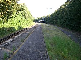
Main Platform - the bridge and shelter are in the far distance Location Place Dumpton Local authority Thanet Operations Station code DMP Managed by Southeastern Number of platforms 2 Live arrivals/departures and station information
from National Rail EnquiriesAnnual rail passenger usage 2004/05 * 35,107 2005/06 *  45,092
2006/07 * 48,3812007/08 *  45,768
2008/09 * 48,108History Opened 19 July 1926 National Rail - UK railway stations A B C D E F G H I J K L M N O P Q R S T U V W X Y Z * Annual passenger usage based on sales of tickets in stated financial year(s) which end or originate at Dumpton Park from Office of Rail Regulation statistics. Please note: methodology may vary year on year. Dumpton Park railway station serves the district of Dumpton between Broadstairs and Ramsgate, Kent, England and lies on the Chatham Main Line 1 mile (1.6 km) east of Ramsgate. Train services are provided by the Southeastern train operating company.
There are no station buildings, just a few parking spaces and a bridge from the south side of the line to an island platform, with a small shelter at the bottom of the steps. Until 1965 the station served as the interchange between the main line and the nearby Tunnel Railway.
Contents
History
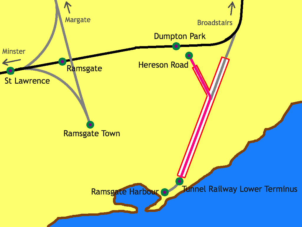
 Layout of pre- and post-1926 lines and stations in Ramsgate

Following the railway grouping of 1923, both the South Eastern Railway and the London, Chatham & Dover Railway became a part of the newly formed Southern Railway, which decided to address the duplication of lines and stations at Ramsgate and Margate. The company decided to link the two lines at Ramsgate to allow through running between them. This scheme had been proposed by the South Eastern and Chatham Railway before World War I, but work did not commence until 1925.[1] This meant the closure of the terminus stations at Ramsgate Town and Ramsgate Harbour, and the construction of a line skirting the northern edge of the town to link the two existing lines. New stations on the north-eastern and north-western fringes of the town, at Dumpton Park and Ramsgate respectively, replaced the existing stations in the town centre and at the harbour.[2] Construction work on the new line involved over 700 men moving 200,000 long tons (220,000 ST; 200,000 t) of chalk, at a cost of approximately £500,000 (£21 million as of 2011).[3][4]
The new link opened on 2 July 1926, from which date both former Ramsgate stations were closed along with the line through the tunnel to Ramsgate Harbour. The tunnel was sealed and abandoned, and the former Ramsgate Harbour station was sold to Thanet Amusements, who converted it into a zoo and funfair called Merrie England.[5] Although adequate for the town's residents the new stations were a long way from the seafront attractions, which were at the foot of a steep hill. The day-trippers on whom Ramsgate's tourist industry depended were therefore increasingly attracted to Margate, where the station was next to the beach.[6]
By 1933 Merrie England, now under the ownership of Ramsgate Olympia, had become extremely popular, and Ramsgate Olympia began to lobby the Southern Railway to reopen the line through the tunnel with a new junction station between Dumpton Park and Broadstairs.[7] However, the Southern Railway rejected the proposal as too costly and impractical.[8][9] Ramsgate Olympia and the Southern Railway were keen to make the attractions near the harbour accessible from the railway main line and to provide a service from the seafront to the greyhound stadium at Dumpton Park. The two companies eventually agreed on a scheme by which a new line would use the 780 yards (710 m) of the tunnel nearest the beach, before branching off into a new 364-yard (333 m) tunnel to emerge at a new station at Hereson Road, a 250-yard (230 m) walk from Dumpton Park station.[7] Ramsgate Olympia planned the construction of a large-scale housing estate, charabanc parking facilities, and a 10,000-seat stadium at Dumpton Park to increase passenger numbers and encourage people to use the new rail line.[6]
When Dumpton Park Station was first built there was a booking hall at street-level, like a smaller version of the one currently at Broadstairs and the bridge and steps were covered. The building has since been demolished and the covering removed, probably in the 1970s but no date seems to be available.
Services
As of May 2011[update] the typical off-peak service from the station is one train per hour to London Victoria via Margate, Faversham and the Medway Towns and one train per hour to Ramsgate only.[10]
Preceding station  National Rail
Following station Ramsgate Southeastern
Chatham Main Line - Ramsgate BranchBroadstairs Notes and references
- ^ Mitchell and Smith, § 104
- ^ Harding, p. 6
- ^ Mitchell and Smith, § 105
- ^ UK CPI inflation numbers based on data available from Lawrence H. Officer (2010) "What Were the UK Earnings and Prices Then?" MeasuringWorth.
- ^ Harding, p. 7
- ^ a b "Round the World in Five Minutes! On Ramsgate's underground railway". East Kent Times (Ramsgate). 1936-06-13.
- ^ a b Harding, p. 8
- ^ "Ramsgate's New Underground Railway". East Kent Times (Ramsgate). 1936-08-05.
- ^ The new Dumpton Park station and Broadstairs station were less than a mile apart; a junction station between the two would have meant trains stopping three times within a mile, causing delays and tailbacks, while running trains from the harbour to Dumpton Park or Broadstairs would have caused severe line congestion.
- ^ Network Rail Timetable May 2011: Table 212
Bibliography
External links
- Train times and station information for Dumpton Park railway station from National Rail
Categories:- Thanet
- Railway stations in Kent
- Former Southern Railway stations
- Railway stations opened in 1926
- Railway stations served by Southeastern
- DfT Category F2 stations


Wikimedia Foundation. 2010.