- Conway, Massachusetts
-
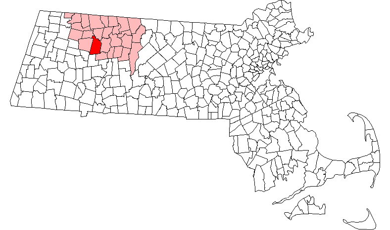
Conway, Massachusetts — Town — Conway Town Hall Location in Franklin County in Massachusetts
Coordinates: 42°30′35″N 72°42′00″W / 42.50972°N 72.7°WCoordinates: 42°30′35″N 72°42′00″W / 42.50972°N 72.7°W Country United States State Massachusetts County Franklin Settled 1762 Incorporated 1775 Government – Type Open town meeting Area – Total 37.8 sq mi (98.0 km2) – Land 37.7 sq mi (97.7 km2) – Water 0.1 sq mi (0.3 km2) Elevation 620 ft (189 m) Population (2000) – Total 1,809 – Density 48.0/sq mi (18.5/km2) Time zone Eastern (UTC-5) – Summer (DST) Eastern (UTC-4) ZIP code 01341 Area code(s) 413 FIPS code 25-15200 GNIS feature ID 0618161 Website www.townofconway.com Conway is a town in Franklin County, Massachusetts, United States. The population was 1,809 at the 2000 census. It is part of the Springfield, Massachusetts Metropolitan Statistical Area.
Contents
History
Conway was first settled in 1762 as the southwest portion of Deerfield. The town was eventually separated and was officially incorporated in 1775. The town was named for General Henry Seymour Conway, a leader in the British House of Commons during repeal of the Stamp Act. (Conway, New Hampshire, as well as other towns across the country, were also named for him.) The town was known for its sheep farming and other agrarian pursuits in its early years, with some industry along the South River which was washed out in a dam break in 1869. Today the town is still mostly a farming community.[1]
Geography
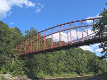 Historic Bardwell's Ferry Bridge
According to the United States Census Bureau, the town has a total area of 37.8 square miles (98 km2), of which, 37.7 square miles (98 km2) of it is land and 0.1 square miles (0.26 km2) of it (0.29%) is water. Conway is in the central part of the county, and is bordered by Shelburne to the north, Deerfield to the east, Whately to the southeast, Williamsburg to the south, Goshen to the southwest, Ashfield to the west, and Buckland to the northwest. Conway is ten miles southwest of Greenfield, 32 miles north-northwest of Springfield, and 99 miles west-northwest of Boston.
Conway lies south of the Deerfield River, which makes most of its northern border. The Bardwell's Ferry Bridge connects Conway to Shelburne across the Deerfield River. The town lies along the South River, which flows from Ashfield to the Deerfield River through the town, with many brooks feeding it as well as the nearby Mill River through Deerfield. The town is dotted with forests and hills, and is home to several state forests, including Conway State Forest, South River State Forest, and the Poland Brook State Wildlife Management Area.
Route 116 passes through the center of town, from Ashfield in the east towards Deerfield, along its way towards Springfield. Deerfield also has the nearest exits of Interstate 91, the nearest interstate highway to the town. A stretch of freight rail passes through the northern part of town, along the banks of the Deerfield River, between Deerfield and the Hoosac Tunnel to the west. The nearest passenger rail service can be reached at Amtrak station in Amherst, with the nearest bus service in Deerfield. The nearest small airport is in Turners Falls, with the nearest national air service being at Bradley International Airport in Windsor Locks, Connecticut.
Demographics
Historical populations Year Pop. ±% 1850 1,831 — 1860 1,689 −7.8% 1870 1,460 −13.6% 1880 1,760 +20.5% 1890 1,451 −17.6% 1900 1,458 +0.5% 1910 1,230 −15.6% 1920 961 −21.9% 1930 900 −6.3% 1940 944 +4.9% 1950 873 −7.5% 1960 875 +0.2% 1970 998 +14.1% 1980 1,213 +21.5% 1990 1,529 +26.1% 2000 1,809 +18.3% 2001* 1,835 +1.4% 2002* 1,861 +1.4% 2003* 1,879 +1.0% 2004* 1,886 +0.4% 2005* 1,896 +0.5% 2006* 1,896 +0.0% 2007* 1,897 +0.1% 2008* 1,903 +0.3% 2009* 1,896 −0.4% 2010 1,897 +0.1% * = population estimate.
Source: United States Census records and Population Estimates Program data.[2][3][4][5][6][7][8][9][10][11]As of the census[12] of 2000, there were 1,809 people, 692 households, and 512 families residing in the town. By population, Conway ranked twelfth of the twenty-six towns in Franklin County, and 295th of the 351 cities and towns in Massachusetts. The population density was 48.0 people per square mile (18.5/km²), which ranked sixteenth in the county and 312th in the Commonwealth. There were 749 housing units at an average density of 19.9 per square mile (7.7/km²). The racial makeup of the town was 98.73% White, 0.17% African American, 0.22% Native American, 0.50% Asian, 0.11% from other races, and 0.28% from two or more races. Hispanic or Latino of any race were 0.94% of the population.
There were 692 households out of which 36.3% had children under the age of 18 living with them, 61.4% were married couples living together, 9.0% had a female householder with no husband present, and 25.9% were non-families. 18.8% of all households were made up of individuals and 5.2% had someone living alone who was 65 years of age or older. The average household size was 2.61 and the average family size was 3.01.
In the town the population was spread out with 25.2% under the age of 18, 5.3% from 18 to 24, 28.9% from 25 to 44, 31.2% from 45 to 64, and 9.5% who were 65 years of age or older. The median age was 40 years. For every 100 females there were 97.9 males. For every 100 females age 18 and over, there were 96.2 males.
The median income for a household in the town was $56,094, and the median income for a family was $62,917. Males had a median income of $41,146 versus $32,273 for females. The per capita income for the town was $25,605. About 2.5% of families and 3.5% of the population were below the poverty line, including 2.6% of those under age 18 and 4.0% of those age 65 or over.
Government
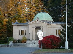 Field Memorial Library
Conway employs the open town meeting form of government, and is led by a board of selectmen and an administrative assistant. The town offices, police station, fire station, post office and Field Memorial Library (donated to the town by Marshall Field and named for his family) are all located in the center of town. The nearest hospital, Franklin Medical Center, is located in Greenfield, as are most of the nearest state offices.
On the state level, Conway is represented in the Massachusetts House of Representatives by the First Franklin district, which includes the southeastern third of Franklin County and towns in north central Hampshire County. In the Massachusetts Senate, the town is represented by the Berkshire, Hampshire and Franklin district, which includes all of Berkshire County, as well as much of western Franklin and Hampshire Counties.[13] The town is patrolled by the Second (Shelburne Falls) Barracks of Troop "B" of the Massachusetts State Police.[14]
On the national level, Conway is represented in the United States House of Representatives as part of Massachusetts's 1st congressional district, and has been represented by John Olver of Amherst since June 1991. Massachusetts is currently represented in the United States Senate by Senators John Kerry and Scott Brown.
Education
Conway is a member of Frontier Regional and Union 38 School Districts, which also includes Deerfield, Whately and Sunderland. Each town operates its own elementary school, with Conway Grammar School serving the town's students from kindergarten through sixth grades. All four towns send seventh through twelfth grade students to Frontier Regional High School in Deerfield. There are several private, religious and charter schools located in the Greenfield and Deerfield area, with the nearest being the Deerfield Academy.
The nearest community college, Greenfield Community College, is located in Greenfield. The nearest state colleges are Massachusetts College of Liberal Arts in North Adams, and the nearest state universities are Westfield State University and the University of Massachusetts Amherst. The nearest private colleges, including members of the Five Colleges and Seven Sisters, are located southeast in the Northampton area.
Notable natives and residents
- John Avery, (1837–1887), educator, first citizen of the United States to be admitted to the Royal Asiatic Society[15]
- Marshall Field, Marshall Field and Company founder
- Holly Hobbie, author of children's books and the creator of the fictional character that bears her name.
- Archibald MacLeish (May 7, 1892 – April 20, 1982) American poet associated with the modernist school of poetry, writer, Librarian of Congress, three-time Pulitzer Prize winner
- Erin McKeown, musician
References
- ^ Town of Conway - Franklin County Chamber of Commerce
- ^ "TOTAL POPULATION (P1), 2010 Census Summary File 1, All County Subdivisions within Massachusetts". United States Census Bureau. http://factfinder2.census.gov/bkmk/table/1.0/en/DEC/10_SF1/P1/0400000US25.06000. Retrieved September 13, 2011.
- ^ "Massachusetts by Place and County Subdivision - GCT-T1. Population Estimates". United States Census Bureau. http://factfinder.census.gov/servlet/GCTTable?_bm=y&-geo_id=04000US25&-_box_head_nbr=GCT-T1&-ds_name=PEP_2009_EST&-_lang=en&-format=ST-9&-_sse=on. Retrieved July 12, 2011.
- ^ "1990 Census of Population, General Population Characteristics: Massachusetts". US Census Bureau. December 1990. Table 76: General Characteristics of Persons, Households, and Families: 1990. 1990 CP-1-23. http://www.census.gov/prod/cen1990/cp1/cp-1-23.pdf. Retrieved July 12, 2011.
- ^ "1980 Census of the Population, Number of Inhabitants: Massachusetts". US Census Bureau. December 1981. Table 4. Populations of County Subdivisions: 1960 to 1980. PC80-1-A23. http://www2.census.gov/prod2/decennial/documents/1980a_maABC-01.pdf. Retrieved July 12, 2011.
- ^ "1950 Census of Population". Bureau of the Census. 1952. Section 6, Pages 21-10 and 21-11, Massachusetts Table 6. Population of Counties by Minor Civil Divisions: 1930 to 1950. http://www2.census.gov/prod2/decennial/documents/23761117v1ch06.pdf. Retrieved July 12, 2011.
- ^ "1920 Census of Population". Bureau of the Census. Number of Inhabitants, by Counties and Minor Civil Divisions. Pages 21-5 through 21-7. Massachusetts Table 2. Population of Counties by Minor Civil Divisions: 1920, 1910, and 1920. http://www2.census.gov/prod2/decennial/documents/41084506no553ch2.pdf. Retrieved July 12, 2011.
- ^ "1890 Census of the Population". Department of the Interior, Census Office. Pages 179 through 182. Massachusetts Table 5. Population of States and Territories by Minor Civil Divisions: 1880 and 1890. http://www2.census.gov/prod2/decennial/documents/41084506no553ch2.pdf. Retrieved July 12, 2011.
- ^ "1870 Census of the Population". Department of the Interior, Census Office. 1872. Pages 217 through 220. Table IX. Population of Minor Civil Divisions, &c. Massachusetts. http://www2.census.gov/prod2/decennial/documents/1870e-05.pdf. Retrieved July 12, 2011.
- ^ "1860 Census". Department of the Interior, Census Office. 1864. Pages 220 through 226. State of Massachusetts Table No. 3. Populations of Cities, Towns, &c.. http://www2.census.gov/prod2/decennial/documents/1860a-08.pdf. Retrieved July 12, 2011.
- ^ "1850 Census". Department of the Interior, Census Office. 1854. Pages 338 through 393. Populations of Cities, Towns, &c.. http://www2.census.gov/prod2/decennial/documents/1850c-11.pdf. Retrieved July 12, 2011.
- ^ "American FactFinder". United States Census Bureau. http://factfinder.census.gov. Retrieved 2008-01-31.
- ^ List of Massachusetts Legislators by City and Town
- ^ Station B-2, SP Shelburne Falls
- ^ Who Was Who in America, Historical Volume, 1607-1896. Chicago: Marquis Who's Who. 1963.
External links
Municipalities and communities of Franklin County, Massachusetts City 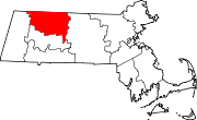
Towns Ashfield | Bernardston | Buckland | Charlemont | Colrain | Conway | Deerfield | Erving | Gill | Hawley | Heath | Leverett | Leyden | Monroe | Montague | New Salem | Northfield | Orange | Rowe | Shelburne | Shutesbury | Sunderland | Warwick | Wendell | Whately
CDPs Other
villagesLake Pleasant | Satans Kingdom | Zoar
Categories:- Towns in Franklin County, Massachusetts
- Springfield, Massachusetts metropolitan area
- Populated places established in 1762


Wikimedia Foundation. 2010.