- Northfield (CDP), Massachusetts
-
Northfield, Massachusetts — CDP — Coordinates: 42°42′16″N 72°26′39″W / 42.70444°N 72.44417°WCoordinates: 42°42′16″N 72°26′39″W / 42.70444°N 72.44417°W Country United States State Massachusetts County Franklin Area – Total 4.5 sq mi (11.6 km2) – Land 4.5 sq mi (11.6 km2) – Water 0.0 sq mi (0.0 km2) Elevation 295 ft (90 m) Population (2000) – Total 1,141 – Density 255.3/sq mi (98.6/km2) Time zone Eastern (EST) (UTC-5) – Summer (DST) EDT (UTC-4) ZIP codes 01354, 01360 Area code(s) 413 FIPS code 25-47800 GNIS feature ID 0609322 Northfield is a census-designated place (CDP) in the town of Northfield in Franklin County, Massachusetts, United States. The population was 1,141 at the 2000 census. It is part of the Springfield, Massachusetts Metropolitan Statistical Area. It is also home to the Northfield campus of Northfield Mount Hermon School.
Geography
According to the United States Census Bureau, the CDP has a total area of 11.6 km² (4.5 mi²). 11.6 km² (4.5 mi²) of it is land and 0.22% is water.
Demographics
As of the census[1] of 2000, there were 1,141 people, 495 households, and 307 families residing in the CDP. The population density was 98.6/km² (255.3/mi²). There were 567 housing units at an average density of 49.0/km² (126.9/mi²). The racial makeup of the CDP was 97.90% White, 0.09% Black or African American, 0.53% Native American, 0.26% Asian, and 1.23% from two or more races. Hispanic or Latino of any race were 0.79% of the population.
There were 495 households out of which 28.5% had children under the age of 18 living with them, 49.9% were married couples living together, 9.5% had a female householder with no husband present, and 37.8% were non-families. 34.1% of all households were made up of individuals and 14.3% had someone living alone who was 65 years of age or older. The average household size was 2.31 and the average family size was 2.98.
In the CDP the population was spread out with 24.0% under the age of 18, 6.7% from 18 to 24, 23.7% from 25 to 44, 29.4% from 45 to 64, and 16.3% who were 65 years of age or older. The median age was 43 years. For every 100 females there were 85.5 males. For every 100 females age 18 and over, there were 80.2 males.
The median income for a household in the CDP was $45,580, and the median income for a family was $56,146. Males had a median income of $41,603 versus $27,308 for females. The per capita income for the CDP was $23,920. About 1.0% of families and 3.9% of the population were below the poverty line, including 3.0% of those under age 18 and 9.4% of those age 65 or over.
References
- ^ "American FactFinder". United States Census Bureau. http://factfinder.census.gov. Retrieved 2008-01-31.
Municipalities and communities of Franklin County, Massachusetts City 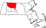
Towns Ashfield | Bernardston | Buckland | Charlemont | Colrain | Conway | Deerfield | Erving | Gill | Hawley | Heath | Leverett | Leyden | Monroe | Montague | New Salem | Northfield | Orange | Rowe | Shelburne | Shutesbury | Sunderland | Warwick | Wendell | Whately
CDPs Millers Falls | Northfield | Orange | Shelburne Falls | South Deerfield | Turners Falls
Other
villagesLake Pleasant | Satans Kingdom | Zoar
Categories:- Census-designated places in Franklin County, Massachusetts
- Springfield, Massachusetts metropolitan area

Wikimedia Foundation. 2010.