- Columbia Falls, Maine
-
Columbia Falls, Maine — Town — Town Hall and Pleasant River c. 1908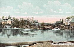 Location within the state of Maine
 Columbia Falls, Maine
Coordinates: 44°39′52″N 67°43′11″W / 44.66444°N 67.71972°W Country United States State Maine County Washington Incorporated 1863 Area – Total 24.7 sq mi (63.9 km2) – Land 24.5 sq mi (63.5 km2) – Water 0.1 sq mi (0.4 km2) Elevation 154 ft (47 m) Population (2000) – Total 599 – Density 24.4/sq mi (9.4/km2) Time zone Eastern (EST) (UTC-5) – Summer (DST) EDT (UTC-4) ZIP code 04623 Area code(s) 207 FIPS code 23-13820 GNIS feature ID 0582415 Columbia Falls is a town in Washington County, Maine, United States. The population was 599 at the 2000 census.
Contents
History
The town began as Township 13 SD, BPP, which was joined together with Township 12 by the Massachusetts General Court on February 8, 1796 and incorporated as Columbia. It was settled soon after the Revolutionary War.[1] On March 25, 1863, the town was set off from Columbia and incorporated as Columbia Falls.[2]
Lumbering and shipbuilding brought the town prosperity and endowed it with some fine early architecture. This includes the Ruggles House (1818–1820), an exquisite Federal home that is now a museum, and the Union Church (1849), a Greek Revival meeting house which since 1902 has housed the town hall, library and archives. The Washington County Railroad arrived at Columbia Falls in 1898. Tourism and harvesting blueberries are important industries today, together with producing Christmas trees and wreaths.[2]
Geography
According to the United States Census Bureau, the town has a total area of 24.7 square miles (64 km2), of which, 24.5 square miles (63 km2) of it is land and 0.1 square miles (0.26 km2) of it (0.57%) is water. Columbia Falls is drained by the Pleasant River.
The town is crossed by U.S. Route 1 and Maine State Route 187.
Demographics
As of the census[3] of 2000, there were 599 people, 251 households, and 168 families residing in the town. The population density was 24.4 people per square mile (9.4/km²). There were 310 housing units at an average density of 12.6 per square mile (4.9/km²). The racial makeup of the town was 97.83% White, 0.83% Native American, 0.33% Asian, 0.67% from other races, and 0.33% from two or more races. Hispanic or Latino of any race were 0.67% of the population.
There were 251 households out of which 33.1% had children under the age of 18 living with them, 56.6% were married couples living together, 8.4% had a female householder with no husband present, and 32.7% were non-families. 28.3% of all households were made up of individuals and 11.6% had someone living alone who was 65 years of age or older. The average household size was 2.39 and the average family size was 2.90.
In the town the population was spread out with 24.2% under the age of 18, 6.7% from 18 to 24, 29.0% from 25 to 44, 26.0% from 45 to 64, and 14.0% who were 65 years of age or older. The median age was 38 years. For every 100 females there were 107.3 males. For every 100 females age 18 and over, there were 102.7 males.
The median income for a household in the town was $28,864, and the median income for a family was $40,208. Males had a median income of $28,021 versus $19,625 for females. The per capita income for the town was $14,723. About 12.9% of families and 19.0% of the population were below the poverty line, including 26.1% of those under age 18 and 29.1% of those age 65 or over.
Sites of interest
- Ruggles House[4]
- Union Church, listed on the National Register of Historic Places
- Bucknam House, listed on the National Register of Historic Places
- Samuel Bucknam House, listed on the National Register of Historic Places
- Columbia House, listed on the National Register of Historic Places
Notable people
- Irv Young, professional baseball player
References
- ^ Coolidge, Austin J.; John B. Mansfield (1859). A History and Description of New England. Boston, Massachusetts. p. 95. http://books.google.com/books?id=OcoMAAAAYAAJ&lpg=PA9&dq=coolidge%20mansfield%20history%20description%20new%20england%201859&pg=PA95#v=onepage&q=&f=false.
- ^ a b Maine.gov -- Columbia Falls, Maine
- ^ "American FactFinder". United States Census Bureau. http://factfinder.census.gov. Retrieved 2008-01-31.
- ^ [1]
External links
Municipalities and communities of Washington County, Maine Cities 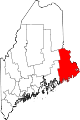
Towns Addison | Alexander | Baileyville | Beals | Beddington | Centerville‡ | Charlotte | Cherryfield | Columbia Falls | Columbia | Cooper | Crawford | Cutler | Danforth | Deblois | Dennysville | East Machias | Harrington | Jonesboro | Jonesport | Lubec | Machias | Machiasport | Marshfield | Meddybemps | Milbridge | Northfield | Pembroke | Perry | Princeton | Robbinston | Roque Bluffs | Steuben | Talmadge | Topsfield | Vanceboro | Waite | Wesley | Whiting | Whitneyville
‡ Disincorporated
Plantations Unorganized
territoriesCDPs Other
villageIndian
reservationsCategories:- Towns in Washington County, Maine


Wikimedia Foundation. 2010.