- Cherryfield, Maine
-
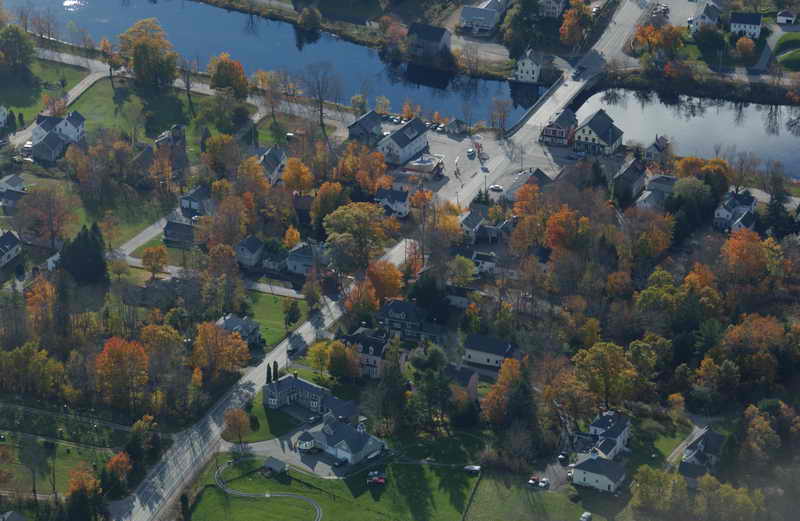
Cherryfield, Maine — Town — Aerial view of central Cherryfield Location within the state of Maine
 Cherryfield, Maine
Coordinates: 44°36′36″N 67°55′46″W / 44.61°N 67.92944°W Country United States State Maine County Washington Area – Total 44.3 sq mi (114.6 km2) – Land 43.7 sq mi (113.3 km2) – Water 0.5 sq mi (1.3 km2) Elevation 118 ft (36 m) Population (2000) – Total 1,157 – Density 26.5/sq mi (10.2/km2) Time zone Eastern (EST) (UTC-5) – Summer (DST) EDT (UTC-4) ZIP code 04622 Area code(s) 207 FIPS code 23-12455 GNIS feature ID 0582407 Cherryfield is a town in Washington County, Maine, United States on the Narraguagus River. It was named for the wild cherries that once peppered the banks of the river.[1] The population was 1,157 at the 2000 census. The town bills itself as the "Blueberry Capital of the World". Roughly 75 acres (300,000 m2) on both sides of the river are a historic district on the National Register of Historic Places known as the Cherryfield Historic District. This district comprises a collection of period structures dating from c1750-1890. The town was first settled about 1760, and was originally part of Steuben, Maine.
Contents
Geography
According to the United States Census Bureau, the town has a total area of 44.2 square miles (114 km2), of which, 43.7 square miles (113 km2) of it is land and 0.5 square miles (1.3 km2) of it (1.18%) is water. The town is home to two breeding pairs of bald eagles.[2]
Demographics
As of the census[3] of 2000, there were 1,157 people, 493 households, and 317 families residing in the town. The population density was 26.5 people per square mile (10.2/km²). There were 644 housing units at an average density of 14.7 per square mile (5.7/km²). The racial makeup of the town was 98.01% White, 0.09% African American, 0.69% Native American, 0.43% Asian, 0.17% from other races, and 0.61% from two or more races. Hispanic or Latino of any race were 0.09% of the population.
There were 493 households out of which 27.4% had children under the age of 18 living with them, 51.7% were married couples living together, 8.1% had a female householder with no husband present, and 35.5% were non-families. 30.6% of all households were made up of individuals and 17.2% had someone living alone who was 65 years of age or older. The average household size was 2.29 and the average family size was 2.85.
In the town the population was spread out with 22.5% under the age of 18, 5.3% from 18 to 24, 24.0% from 25 to 44, 27.5% from 45 to 64, and 20.7% who were 65 years of age or older. The median age was 44 years. For every 100 females there were 87.2 males. For every 100 females age 18 and over, there were 88.1 males.
The median income for a household in the town was $21,486, and the median income for a family was $31,016. Males had a median income of $26,058 versus $20,000 for females. The per capita income for the town was $13,111. About 15.8% of families and 21.9% of the population were below the poverty line, including 24.6% of those under age 18 and 27.5% of those age 65 or over.
Notable people
- Hiram Burnham,Civil War era general.
- Carlton Willey, pitcher for the Braves and Mets.
Economy
- Cherryfield Foods, blueberry processing company.[citation needed]
- Jasper Wyman & Son, blueberry processing company, the manufacturing plant is located in Cherryfield.[4]
References
Further reading
- Wright, Virginia. "The Heart of Cherryfield". Down East: the Magazine of Maine (July 2008).
External links
Varney, George J. (1886). Gazetteer of the state of Maine. Cherryfield. Boston: Russell. http://history.rays-place.com/me/cherryfield-me.htm
Municipalities and communities of Washington County, Maine Cities 
Towns Addison | Alexander | Baileyville | Beals | Beddington | Centerville‡ | Charlotte | Cherryfield | Columbia Falls | Columbia | Cooper | Crawford | Cutler | Danforth | Deblois | Dennysville | East Machias | Harrington | Jonesboro | Jonesport | Lubec | Machias | Machiasport | Marshfield | Meddybemps | Milbridge | Northfield | Pembroke | Perry | Princeton | Robbinston | Roque Bluffs | Steuben | Talmadge | Topsfield | Vanceboro | Waite | Wesley | Whiting | Whitneyville
‡ Disincorporated
Plantations Unorganized
territoriesCDPs Other
villageIndian
reservationsCoordinates: 44°36′26″N 67°55′33″W / 44.60722°N 67.92583°W
Categories:- Towns in Washington County, Maine


Wikimedia Foundation. 2010.