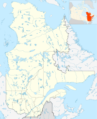
- Côte-Nord-du-Golfe-du-Saint-Laurent, Quebec
-
Côte-Nord-du-Golfe-du-Saint-Laurent — Municipality — The village of Harrington Harbour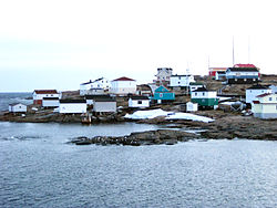
 Côte-Nord-Golfe-St-Laurent
Coordinates: 50°28′N 59°36′W / 50.467°N 59.6°WCoordinates: 50°28′N 59°36′W / 50.467°N 59.6°W Country  Canada
Province  Quebec
Region Côte-Nord Regional county Le Golfe-du-Saint-Laurent Incorporated June 22, 1963 Government[1] – Administrator Richmond Monger – Federal riding Manicouagan – Prov. riding Duplessis Area[2] – Land 2,845.13 km2 (1,098.5 sq mi) Population (2006)[2] – Total 1,028 – Density 0.4/km2 (1/sq mi) Time zone AST (UTC-4) Postal code G0G 1G0 Area code(s) 418 Côte-Nord-du-Golfe-du-Saint-Laurent is a municipality in the Côte-Nord region of the province of Quebec in Canada. The municipality consists of two non-contiguous areas, both along the shores of the Gulf of Saint Lawrence. The larger main part stretches from the Natashquan River to the Big Mecatina River and includes all populated places. The eastern part is a small section between Middle Bay and Brador.
Contents
History
The Municipality of Côte-Nord-du-Golfe-Saint-Laurent was incorporated in 1963 and originally extended along the shores of the Saint Lawrence from the Natashquan River to the Newfoundland and Labrador provincial border, some 5,240 square kilometres (2,020 sq mi) roughly corresponding to the Basse-Côte-Nord territory. However, with an isolated population scattered over a large area devoid of roads, the municipality did not have an elected municipal council and was managed by an appointed administrator headquartered in Chevery.[3]
Starting in 1990, a restructuring plan was enacted that would carve up Côte-Nord-du-Golfe-Saint-Laurent into several additional municipalities. That year, the municipalities of Bonne-Espérance and Blanc-Sablon were formed, followed by the Municipality of Saint-Augustin on December 30, 1992, and finally the municipality of Gros-Mécatina on December 22, 1993.[3]
On May 8, 1996, the municipality's name was officially adjusted to Côte-Nord-du-Golfe-du-Saint-Laurent.[3]
Communities
The municipality includes the communities of Aylmer Sound, Chevery, Harrington Harbour, Kegaska, and Tête-à-la-Baleine.
It also includes the following abandoned settlements and ghost towns, in order from west to east: Musquaro, Wolf Bay, Ettamiau, Pointe Amouri, Barachois, Chez Menneau, and Boulet's (also known as Bully's).
Chevery
Chevery (50°28′07″N 59°36′58″W / 50.46861°N 59.61611°W) is the administrative centre of the municipality, located at the mouth of the Nétagamiou River. Previously known as Netagamu River, the place was renamed in 1971 after captain Jean-Baptiste Chevery who in 1747 sailed along the coast visiting numerous posts.[4]
Chevery was the site of an early French fur trading post in the mid-17th century, but after that fort was abandoned, there was no further development on the site until the 1930s, when an experimental farm was established on the Cross River by William Anderson. Residents of several isolated communities in the area, including Gull Cliff Island and Aylmer Sound, subsequently moved to Chevery due to the need for improved access to government services.[5]
Harrington Harbour
Harrington Harbour (50°30′00″N 59°28′47″W / 50.5°N 59.47972°W) was originally founded near the end of the 19th century by fishermen from Newfoundland.[6] The primary activity is commercial fishing for crabs and scallops.
A heliport is located near the village and wharf facilities located in the village are also used to service the villages of Chevery, where a regional airport is located, and Aylmer Sound.
Harrington Harbour was named after Charles Stanhope, 3rd Earl of Harrington. It is also known locally as "Hospital Island", from its earlier role as a medical centre for the area. Local tradition claims that this is the island on which 16th century French noblewoman Marguerite de La Rocque was marooned by her relative Jean-François Roberval as punishment for an affair.[6] "Marguerite's Cave" is one of the attractions on the island. Another attraction is the Jacques Cartier Monument, commemorating the French explorer and surveyor of the Gulf of St Lawrence.
The village was the location used for the Quebec film Seducing Doctor Lewis.
Kegaska
Kegaska (50°11′01″N 61°16′21″W / 50.18361°N 61.2725°W) is the westernmost community in the municipality, with a population of less than 200 people, mostly anglophone settlers from Anticosti Island. Its name derives from the Innu word quegasca, first recorded on Franquelin's map of 1685.[7][8]
In 1831, Kegaska was the site of a Hudson's Bay Company trading post, but the actual settlement was formed in 1852 when Acadian settlers came from the Magdalen Islands. They abandoned the place in 1871-1873 to settle at Betchewun (now Betchouane between Havre-Saint-Pierre and Baie-Johan-Beetz) and were replaced by Newfoundland fishermen, almost all of Irish origin. They in turn left around 1887-1888, leaving the place completely deserted by 1890. Yet in 1898, a few families relocated from Perth, Ontario, whose descendants now populate the area.[7][8]
Tête-à-la-Baleine
Tête-à-la-Baleine (50°42′10″N 59°19′23″W / 50.70278°N 59.32306°W), occasionally known as Whale Head in English, was settled in the 19th century after Michael Kenty bought the local trading post from the Labrador Company. Initial settlement mostly took place on the nearby islands in the Gulf of St. Lawrence, although eventually most residents moved to the community's current site on the mainland in order to be closer to sources of wood and food in the winter. However, some residents still move back and forth, residing on the islands in summer and in the mainland community in winter.[9]
The community is named after a nearby island in the Gros Mécatina Archipelago that resembles a whale head.[10]
Musquaro
The ghost town of Musquaro (50°12′58″N 61°03′50″W / 50.21611°N 61.06389°W) is at the mouth of the Musquaro River, between Kegaska and La Romaine. Identified as Mascoüarou on Louis Jolliet's map of 1694, the name went through numerous spelling changes, such as Nasquirou, Maskouaro, and Mahkuanu. Its root meaning is "black bear tail" and may refer to the foothills of Mount Mascoüarou as shown Jolliet's map.[11]
It was the site of a fortified trading post, established in 1710, and a catholic mission. In 1780, the post was on the territory granted to the Labrador Company of Quebec. 23 years later, the franchise went to the North West Company which in turn was sold to the Hudson's Bay Company in 1821. Closed for a brief time in 1859, the post remained occupied until 1925 after which it closed permanently.[11]
Demographics
Canada census – Côte-Nord-du-Golfe-du-Saint-Laurent Community Profile 2006 2001 Population:
Land area:
Population density:
Median age:
Total private dwellings:
Mean household income:1028 (-13.1% from 2001)
2,845.43 km2 (1,098.63 sq mi)
0.4 /km2 (1.0 /sq mi)
41.7 (males: 41.7, females: 41.6)
447
$46,9191183 (-2.6% from 1996)
2,845.46 km2 (1,098.64 sq mi)
0.4 /km2 (1.0 /sq mi)
36.8 (males: 36.8, females: 36.7)
487
$40,363Private dwellings occupied by usual residents: 392 (total dwellings: 447)
Mother tongue:
- English as first language: 70 %
- French as first language: 29 %
- English and French as first language: 1 %
- Other as first language: 0 %
Population trend:[14]
- Population in 2006: 1028
- Population in 2001: 1183
- Population in 1996: 1214
- Population in 1991: 1322
Transportation
The municipality is served by three small local airports, Chevery Airport, Kegaska Airport and Tête-à-la-Baleine Airport. Harrington Harbour is served by a heliport, but does not have its own full airport.
Harrington Harbour is located on a small island which has no cars or roads, and all transportation in the community is by bicycle. Each mainland community has local road access — however, no roads currently connect one community to another, the entire municipality is isolated from the provincial highway network, and ferries or taxi boats must be used to travel between the communities or to the rest of the province.
In recent years the municipality has lobbied for Highway 138, which currently ends at Natashquan, to be extended through the area. The provincial government has announced a feasibility study, although no construction schedule has been announced to date.[15]
Climate
Climate data for Tête-à-la-Baleine Month Jan Feb Mar Apr May Jun Jul Aug Sep Oct Nov Dec Year Record high °C (°F) 6.1
(43.0)6.1
(43.0)15
(59)12.8
(55.0)21
(70)32.8
(91.0)31.7
(89.1)30
(86)28.9
(84.0)20.6
(69.1)16.1
(61.0)8.9
(48.0)32.8
(91.0)Average high °C (°F) −8.3
(17.1)−7.1
(19.2)−1.8
(28.8)3.3
(37.9)8.8
(47.8)14.4
(57.9)18.8
(65.8)18.7
(65.7)14.5
(58.1)8.3
(46.9)2.1
(35.8)−5.2
(22.6)5.6 Daily mean °C (°F) −14
(7)−12.9
(8.8)−7.2
(19.0)−0.7
(30.7)4.6
(40.3)9.7
(49.5)14
(57)13.9
(57.0)9.8
(49.6)4.1
(39.4)−1.6
(29.1)−10.1
(13.8)0.8 Average low °C (°F) −19.6
(−3.3)−18.6
(−1.5)−12.5
(9.5)−4.7
(23.5)0.4
(32.7)4.9
(40.8)9.1
(48.4)9.1
(48.4)5.1
(41.2)−0.1
(31.8)−5.4
(22.3)−14.9
(5.2)−3.9 Record low °C (°F) −38.9
(−38.0)−39.5
(−39.1)−35
(−31)−27
(−17)−13.3
(8.1)−2.8
(27.0)−0.6
(30.9)−1.1
(30.0)−5
(23)−14.4
(6.1)−22.2
(−8.0)−35.6
(−32.1)−39.5
(−39.1)Precipitation mm (inches) 78.1
(3.075)52.6
(2.071)73.1
(2.878)78.5
(3.091)97.7
(3.846)112.1
(4.413)111.4
(4.386)111.9
(4.406)128.3
(5.051)129.9
(5.114)116.9
(4.602)102.8
(4.047)1,193.3
(46.98)Source: Environment Canada[16] Media
Two community radio stations, CFTH-FM-1 in Harrington Harbour and CJTB-FM in Tête-à-la-Baleine, operate in the municipality. CFTH also has rebroadcasters in Kegaska and Mutton Bay. The municipality is also served by rebroadcasters of Première Chaîne's CBSI-FM in Harrington Harbour and Tête-à-la-Baleine, and by a rebroadcaster of CBC Radio One's CBVE-FM in Harrington Harbour.
Télévision de Radio-Canada's CJBR-TV has rebroadcasters in Harrington Harbour and Tête-à-la-Baleine, and CBC Television's CBMT has a rebroadcaster in Harrington Harbour. The municipality does not receive any of Canada's commercial broadcast television networks, English or French, over the air.
References
- ^ Ministère des Affaires Municipales, Régions et Occupation du territoire - Répertoire des municipalités: Côte-Nord-du-Golfe-du-Saint-Laurent
- ^ a b "Côte-Nord-du-Golfe-du-Saint-Laurent community profile". 2006 Census of Population. Statistics Canada. 2007-03-13. http://www12.statcan.gc.ca/census-recensement/2006/dp-pd/prof/92-591/details/page.cfm?Lang=E&Geo1=CSD&Code1=2498015&Geo2=PR&Code2=24&Data=Count&SearchText=cote-nord&SearchType=Begins&SearchPR=01&B1=All&Custom=. Retrieved 2010-09-21.
- ^ a b c "Côte-Nord-du-Golfe-du-Saint-Laurent (Municipalité)" (in French). Commission de toponymie du Québec. http://www.toponymie.gouv.qc.ca/ct/ToposWeb/fiche.aspx?no_seq=336447. Retrieved 2010-09-21.
- ^ "Chevery (village)" (in French). Commission de toponymie du Québec. http://www.toponymie.gouv.qc.ca/ct/ToposWeb/fiche.aspx?no_seq=13070. Retrieved 2010-09-21.
- ^ Tourism Lower North Shore: Chevery
- ^ a b Tourism Lower North Shore: Harrington Harbour
- ^ a b Tourism Lower North Shore: Kegaska
- ^ a b "Kegaska (village)" (in French). Commission de toponymie du Québec. http://www.toponymie.gouv.qc.ca/ct/ToposWeb/fiche.aspx?no_seq=142821. Retrieved 2010-09-21.
- ^ Tourism Lower North Shore: Tête-à-la-Baleine
- ^ "Tête-à-la-Baleine (village)" (in French). Commission de toponymie du Québec. http://www.toponymie.gouv.qc.ca/ct/ToposWeb/fiche.aspx?no_seq=62203. Retrieved 2010-09-21.
- ^ a b "Musquaro (hameau)" (in French). Commission de toponymie du Québec. http://www.toponymie.gouv.qc.ca/ct/ToposWeb/fiche.aspx?no_seq=43159. Retrieved 2010-09-21.
- ^ "2006 Community Profiles". Statistics Canada. Government of Canada. 2009-02-24. http://www12.statcan.ca/census-recensement/2006/dp-pd/prof/92-591/index.cfm?Lang=E. Retrieved 2011-04-29.
- ^ "2001 Community Profiles". Statistics Canada. Government of Canada. 2007-02-01. http://www12.statcan.ca/english/profil01/CP01/Index.cfm?Lang=E. Retrieved 2011-04-29.
- ^ Statistics Canada: 1996, 2001, 2006 census
- ^ "New Quebec highway good for Labrador economy: exporter". CBC News. 2006-08-25. http://www.cbc.ca/canada/newfoundland-labrador/story/2006/08/25/labrador-quebec.html?ref=rss. Retrieved 2007-08-17.
- ^ Environment Canada—Canadian Climate Normals 1971–2000. Retrieved 23 January 2010.
External links
- Western main part

Petit-Mécatina Gros-Mécatina Natashquan Twp. 
Gulf of Saint Lawrence  Côte-Nord-du-Golfe-du-St-Laurent (surrounds La Romaine)

Natashquan Gulf of Saint Lawrence - Small eastern part
Petit-Mécatina Bonne-Espérance Blanc-Sablon Côte-Nord-du-Golfe-du-St-Laurent Gulf of Saint Lawrence Administrative divisions of Côte-Nord (Region 09)Regional county municipalities
and equivalent territoriesLa Haute-Côte-Nord · Le Golfe-du-Saint-Laurent · Manicouagan · Sept-Rivières · Caniapiscau · Minganie
Municipalities Forestville · Baie-Comeau · Sept-Îles · Port-Cartier · Havre-Saint-Pierre · Fermont · Schefferville
Categories:- Municipalities in Quebec
- Incorporated places in Côte-Nord
- Quebec communities with significant anglophone populations


Wikimedia Foundation. 2010.