- Anticosti Island
Infobox Islands
name = Anticosti
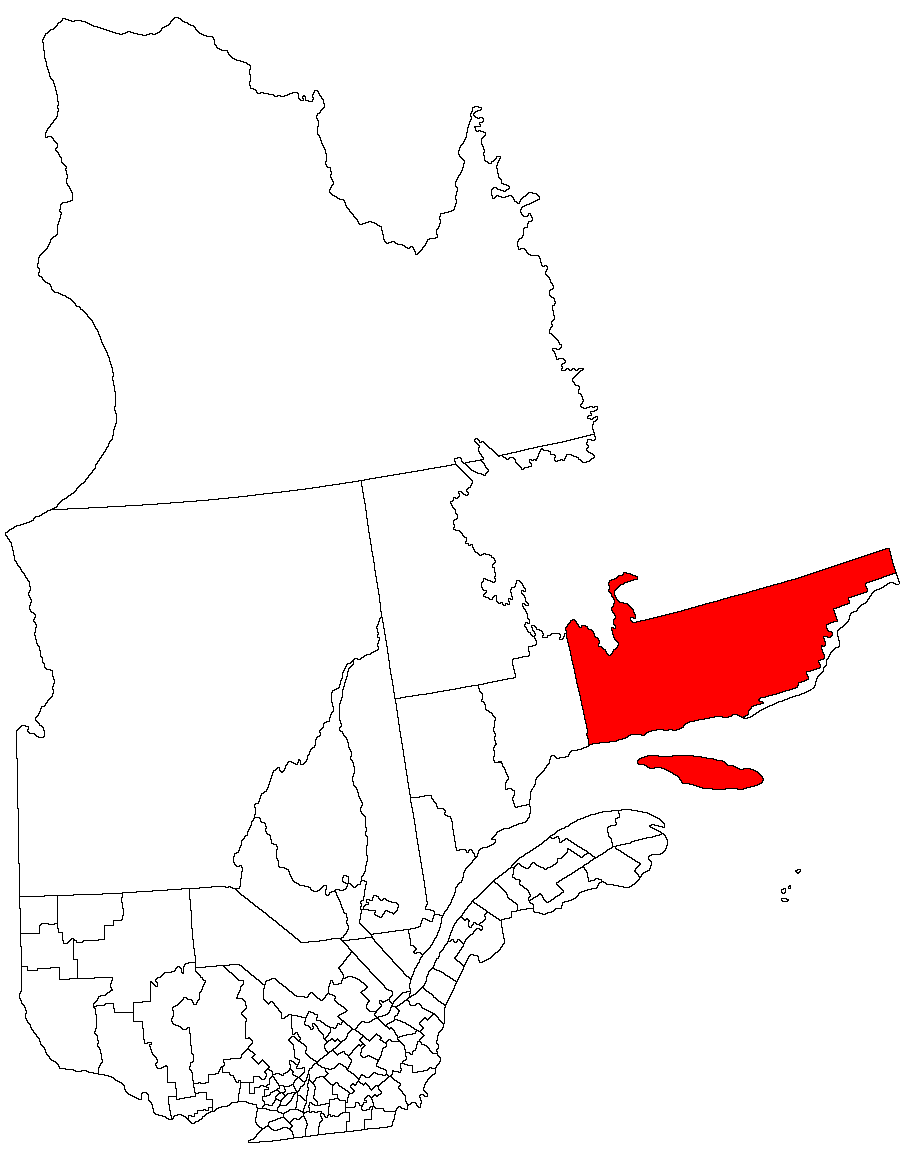
image caption = Anticosti Island in theGulf of Saint Lawrence
image size =
locator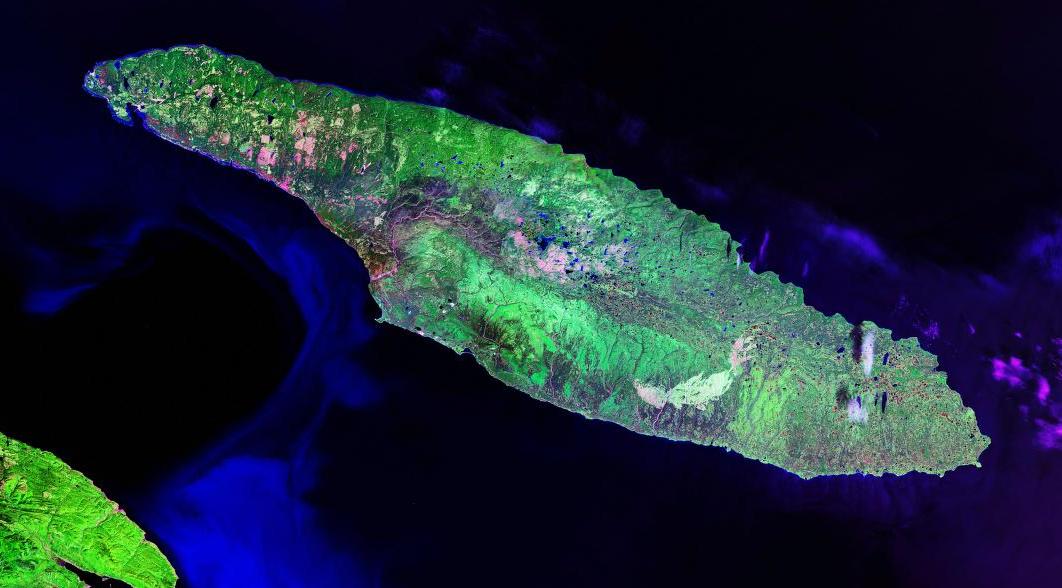
map_custom = no
native name = "Île d'Anticosti"
native name link = French language
nickname =
location =Gulf of Saint Lawrence
coordinates = coord|49|30|N|63|00|W|display=inline
archipelago =
total islands =
major islands =
area = convert|7892.52|km2|sqmi|abbr=on
length = convert|217|km|mi|abbr=on
width = {convert|16|-|48|km|sigfig=1|disp=s|abbr=on
highest mount =
elevation =
country = Canada
country admin divisions title = Province
country admin divisions = flag|Quebec
country admin divisions title 1 = Administrative Region
country admin divisions 1 =Côte-Nord
country admin divisions title 2 = County Regional Municipality of Quebec
country admin divisions 2 = Minganie
country largest city = Port-Menier
country largest city population =
population = 266
population as of = 2001
density = 0.03
ethnic groups =
additional info =Anticosti Island (French, "Île d'Anticosti") is an
island at the outlet of theSaint Lawrence River into theGulf of Saint Lawrence , inQuebec , between 49° and 50° N., and between 61° 40' and 64° 30' W. At km2 to mi2|num=7892.52|abbr=yes|spell=Commonwealth|precision=2|wiki=yes in size, it is the 90th largest island in the world and 20th largest island in Canada. Anticosti Island is separated on the north from theCôte-Nord region of Quebec (theLabrador Peninsula ) by theJacques Cartier Strait and on the south from the Gaspé Peninsula by theHonguedo Strait .It is very large (convert|217|km|disp=s|abbr=on long and convert|16|-|48|km|sigfig=1|disp=s|abbr=on wide—larger than the province of
Prince Edward Island ) but very sparsely populated (266 people in 2001), mostly in the village of Port-Menier on the western tip of the island, consisting chiefly of the keepers of the numerouslighthouse s erected by the Canadian government. The coast is rocky and dangerous, and has only two safe harbours, Ellis Bay and Fox Bay. The largest lake on the island isLake Wickenden , which feeds the Jupiter River.The entire island constitutes one municipality officially known as L'Île-d'Anticosti.
History
For thousands of years, Anticosti Island was the territory of the
indigenous peoples who lived on the mainland and used it as a hunting ground. TheInnu called it Notiskuan, translated as "wherebear s are hunted" and theMi'kmaq called it Natigostec, meaning "forward land". The French explorerJacques Cartier sailed along its shore in the summer of1534 . He called the place Assomption and provided its first written description. By the early 1600sFrance had officially seized the island and made it part of its colonial empire. Its first settlers arrived when in 1680 King Louis XIV gifted toLouis Jolliet the Seigneury of theMingan Archipelago and Anticosti Island. Equal to one-quarter the size of the country ofBelgium , Anticosti thus became the largest island in the world to ever be privately owned. Louis Jolliet erected a fort on Anticosti and in the spring of 1681 settled there with his wife, four children and six servants. His fort was captured and occupied during the winter of 1690 by some of theMassachusetts troops ofWilliam Phips during their retreat after an unsuccessful attempt to captureQuebec City . The Jolliet family retained ownership until 1763 when it became part of theBritish Empire under the terms of the Treaty of Paris that ended theSeven Years' War . In the ensuing years the island property changed hands several times, its owners generally using it for the harvesting of timber. For example, the French CanadianGabriel-Elzéar Taschereau owned it among other seigneuries and made money from them.In 1895 Anticosti was sold to French chocolate maker
Henri Menier who also leased the shore fisheries rights. Menier converted the island into a personal game preserve and named the Island's 70 metre highVauréal Falls after the town ofVauréal in France where he owned a home.Henri Menier constructed the entire village of
Port-Menier , built a cannery for packingfish and lobsters, and attempted to develop its resources of lumber,peat , and minerals. Many of the original houses still stand today. Menier also introduced a herd of 220deer to the island. The deer thrived and today the population exceeds 100,000 while the island's moose population is about 1,000. It has been reported that black bears, which rely on berries to bulk on for the winter, had lived on the island until the introduction, perhaps due to the deer eating the berries bare. ["Revenge of the Venison", p.18, Discover, August 2006.]Henri Menier died in 1913 and his brother Gaston became the owner of Anticosti Island. He used and maintained it for a time but eventually decided it was not an economically viable proposition and sold it to the Wayagamack Pulp and Paper Company in 1926.
In 1937, the government of Germany, led at the time by
Adolf Hitler , tried unsuccessfully to buy the island. Canadian Prime MinisterWilliam Lyon Mackenzie King became involved, and forbade the Nazis' plan.fact|date=July 2008In 1974, the government of Quebec purchased the island. About 60% is under management by
Sépaq and since April 2001, km2 to mi2|572|precision=0 has been designated as a national conservation park. With its 24 rivers and streams bountiful withsalmon andtrout , it is now a paradise for paleontologists, bird watchers, hikers, and a major draw for anglers and hunters, particularly those from theUnited States .References
* E. Billings, "Geological Survey of Canada: Catalogue of the Silurian Fossils of Anticosti" (Montreal, 1866)
* Logan, "Geological Survey of Canada, Report of Progress from its Commencement to 1863" (Montreal, 1863–1865)
* Gretchen Eshbaugh Engel, "Though Memory Plays Me False. A Story of Anticosti. The St. Lawrence River Isle of Enchantment, the life of William Hardy Eshbaugh and the role he played in its early development." (Southbury, CT, 1971)
* Charlie McCormick. "Anticosti". (1996) Éditions JCL ISBN 2-89431-152-4
* Donald MacKay. "Anticosti, The Untamed Island". (1979) McGraw-Hill Ryerson ISBN 0-07-082933-0
* Henri Menier. "Anticosti, 1905". (Paris? 1905?). 30 original photographs by Henri Menier. Autographed presentation copy to Lord Grey. Collection of University of Saskatchewan Library, Saskatoon, Canada.
*Alberta C. Pew,Joseph N. Pew, Jr. , Margaret R. Leisenring, Edward B. Leisenring, Jay Cooke, "A.E.F.: Anticosti Expeditionary Force" (Philadelphia?: Privately Printed, 1935). Account of a private fishing expedition to the island.
* J. Schmitt, "Anticosti" (Paris, 1904).
* [http://www12.statcan.ca/english/Profil01/CP01/Details/Page.cfm?Lang=E&Geo1=CSD&Code1=2498020&Geo2=PR&Code2=24&Data=Count&SearchText=L'Ile&SearchType=Begins&SearchPR=24&B1=All&Custom= Community Profile: L'Île-d'Anticosti Municipalité, Minganie-Basse-Côte-Nord, Québec; Statistics Canada]External links
* [http://www.sepaq.com/pq/pan/en/ Sépaq official website]
Wikimedia Foundation. 2010.